List of communities in Cumberland County, Nova Scotia
Communities are ordered by the highway on which they are located, whose routes start after each terminus near the largest community.

Cumberland County is a county in the Canadian province of Nova Scotia.
Highway 104 in Nova Scotia, Canada, runs from Fort Lawrence at the New Brunswick border near Amherst to River Tillard near St. Peter's. Except for the portion on Cape Breton Island between Port Hawkesbury and St. Peter's, it forms the main route of the Trans-Canada Highway across the province.

Parrsboro is a community located in Cumberland County, Nova Scotia, Canada.

The Chignecto-Central Regional Centre for Education is a Canadian public school district in Nova Scotia.

Trunk 2 is part of the Canadian province of Nova Scotia's system of Trunk Highways. The route runs from Halifax to Fort Lawrence on the New Brunswick border. Until the 1960s, Trunk 2 was the Halifax area's most important highway link to other provinces, and was part of a longer Interprovincial Highway 2 which ended in Windsor, Ontario. The controlled access Highway 102 and Highway 104 now carry most arterial traffic in the area, while Trunk 2 serves regional and local traffic.

Trunk 4 is part of the Canadian province of Nova Scotia's system of Trunk Highways. The route runs from Highway 104 exit 7 near Thomson Station to Glace Bay. Until the construction of the Trans-Canada Highway, Trunk 4 was a major traffic link in northern Nova Scotia and Cape Breton, and is still used on Cape Breton as an alternative to Highway 105. The highway was originally called the King's Highway, however, this name is no longer applied to the entire road. The only remaining historic section of the highway that maintains the name "King" is King's Road in Sydney.

Trunk 6 is part of the Canadian province of Nova Scotia's system of trunk highways. The route runs from Highway 104 exit 3 at Amherst to the rotary at Pictou, a distance of 136 kilometres (85 mi). It is part of the Sunrise Trail, a designated tourist route.
The Glooscap Trail is a scenic roadway in the Canadian province of Nova Scotia.

The Sunrise Trail is a scenic roadway in the Canadian province of Nova Scotia. It is located along the province's North Shore on the Northumberland Strait for 333 km (207 mi) from Amherst to the Canso Causeway.
Route 204 is a collector road in the Canadian province of Nova Scotia.
The Fundy Shore Ecotour is a former scenic drive and network of tourist destinations in the Canadian province of Nova Scotia and encircles several sub-basins of the Bay of Fundy, which contains the highest tidal range on the planet.
Route 368 is a collector road in the Canadian province of Nova Scotia.
Route 366 is a collector road in the Canadian province of Nova Scotia.
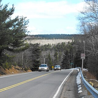
Route 321 is a collector road in the Canadian province of Nova Scotia.
The Wentworth Valley is a valley in the Cobequid Mountains of northwestern Nova Scotia, Canada. It comprises the lowest elevation pass through the Cobequids. It was named after the colonial governor John Wentworth (1792-1808).
Eastlink Community TV is the brand for Eastlink's community channels that serve Northern Ontario, New Brunswick, Newfoundland and Labrador, Nova Scotia and Prince Edward Island. As of 2009, the company's systems in Western Canada are served by the distinct PersonaTV division.
The Cumberland Railway and Coal Company is a defunct Canadian industrial company with interests in coal mines in Springhill, Nova Scotia, and a railway that operated from Springhill Junction to Parrsboro.
Springhill Junction is a rural community in central Cumberland County, Nova Scotia, Canada. It is approximately 4 kilometres (2.5 mi) northwest of Springhill, Nova Scotia.
The Fundy Shore Scenic Drive is a scenic drive in the Canadian province of Nova Scotia. It located along the northeastern portion of the Bay of Fundy, following the Chignecto Peninsula which separates Chignecto Bay and Minas Basin, an area which contains the highest tidal range on the planet.