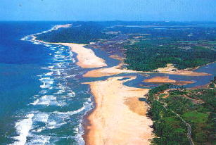
Colorado River Delta

Last updated

Colorado River Delta
Coloradoriverdelta oli APR2020.jpg
Satellite view of the Colorado River Delta featuring Isla Montague and the Ciénaga de Santa Clara wetland
Mexico relief location map.jpg
Red pog.svg
Colorado River Delta
Location of the Colorado River Delta in Mexico
North America laea relief location map with borders.jpg
Red pog.svg
Colorado River Delta
Location of the Colorado River Delta in North America
Coordinates: 31°44′N114°40′W / 31.74°N 114.66°W / 31.74; -114.66
Location Baja California and Sonora, Mexico
Part of Colorado River
Offshore water bodies Gulf of California
Area
  Total7,810 hectares (19,300 acres) (historical)
Designations
Official nameHumedales del Delta del Río Colorado
Designated20 March 1996
Reference no.814 [1]

The Colorado River Delta is the region where the Colorado River flows into the Gulf of California (also known as the Sea of Cortez) in eastern Mexicali Municipality in the north of the state of Baja California in northwesternmost Mexico. The delta is part of a larger geologic region called the Salton Trough. [2] Historically, the interaction of the river's flow and the ocean's tide created a dynamic environment, supporting freshwater, brackish, and saltwater species. Within the delta region, the river split into multiple braided channels and formed a complex estuary and terrestrial ecosystems. The use of water upstream and the accompanying reduction of freshwater flow has resulted in the loss of most of the wetlands of the area, as well as drastic changes to the aquatic ecosystems. However, a scheme is currently in place which aims to rejuvenate the wetlands by releasing a pulse of water down the river delta. [3]

Contents

Natural history

Until the early 20th century, the Colorado River ran free from its headwaters in the Rocky Mountains of Colorado southwest into Mexico, where it flowed into the Gulf of California. Significant quantities of nourishing silt from throughout the Colorado River Basin were carried downstream, creating the vast Colorado River Delta and preventing intrusion of seawater into the Mexicali and Imperial Valleys. [4]

Prior to the construction of major dams along its route, the Colorado River fed one of the largest desert estuaries in the world. Spread across the northernmost end of the Gulf of California, the Colorado River delta's vast riparian, freshwater, brackish, and tidal wetlands once covered 7,810 km2 (1,930,000 acres) and supported a large population of plant, bird, aquatic, and terrestrial life. [5] Because most of the river's flow reached the delta at that time, its freshwater, silt, and nutrients helped create and sustain a complex system of estuarial wetlands that provided feeding and nesting grounds for birds, and spawning habitat for fish and marine mammals. In contrast to the surrounding Sonoran Desert, the Colorado River delta's abundance was striking. [6]

Human history

Early history

Early explorers reported jaguars, beavers, deer, and coyotes in the delta, in addition to the abundance of waterfowl, fish, and other marine and estuary organisms (Spamer, 1990; {Aldo Leopold, 1948}). Early explorers also encountered local people known as the Cucapá, or the people of the river. The Cucapá are descendants of the Yuman-speaking Native Indigenous peoples of the Americas and have inhabited the delta for nearly a thousand years. Spanish explorer Hernando de Alarcón made the first recorded contact with the Cucapá in 1540 and reported seeing many thousands. The Cucapá used the delta floodplain extensively for harvesting Palmer's saltgrass ( Distichlis palmeri ), a wild grain that grows in salty soil, and for cultivating maize (corn), beans, and squash.

On the map the Delta was bisected by the river, but in fact the river was nowhere and everywhere, for he could not decide which of a hundred green lagoons offered the most pleasant and least speedy path to the Gulf.

Aldo Leopold, from A Sand County Almanac , describing the Colorado River Delta as it existed in 1922

After dam construction

Today, conditions in the delta have changed. Like other desert river deltas, such as the Nile Delta and the Indus River Delta, the Colorado River delta has been greatly altered by human activity. Decades of dam construction and water diversions in the United States and Mexico have reduced the delta to a remnant system of small wetlands and brackish mudflats. [7] As reservoirs filled behind dams and captured floodwaters, freshwater could no longer reach the delta.

The construction of Hoover Dam in the 1930s marked the beginning of the modern era for the Colorado River Delta. For six years, as Lake Mead filled behind the dam, virtually no freshwater reached the delta. Even spring flooding was captured. This ecologically devastating event was repeated from 1963 to 1981 as Lake Powell filled behind the Glen Canyon Dam. With these reservoirs now filled, the dams are used to regulate flow so that water can be reliably apportioned among the users of the Colorado River Compact, and its use maximized. Most flood flows can be contained, regulated, and added to the river's capacity to sustain the Western United States' urban centers and agriculture. Floodwaters are released only when the Bureau of Reclamation, the agency managing the dams, predicts flows that exceed the system's capacity for use and storage.

The loss of freshwater flows to the delta over the twentieth century has reduced delta wetlands to about 5 percent of their original extent, and non-native species have compromised the ecological health of much of what remains. Stress on ecosystems has allowed invasive plants to out-compete native species along Colorado River riparian areas. Native forests of cottonwood and willow have yielded to sand and mudflats dominated by the nonnative tamarisk (also known as salt cedar), arrow-weed, and iodine bush, a transformation that has decreased the habitat value of the riparian forest. [8]

High flows in 1980s

Full reservoir conditions coupled with a series of flood events throughout the 1980s and early 1990s resulted in flood releases that reached the delta. These flows reestablished an active floodplain and revegetated many areas of the floodplain within irrigation and flood control levels, and helped to reestablish riparian forests.

Ecology

The delta supports a variety of wildlife, including several threatened and endangered species. Mexico's Environmental Regulations on Endangered Species lists the following endangered species found in the terrestrial and aquatic regions of the delta (Diario Officiel, 1994):

Although not extensively studied, the delta's significance for migratory birds is indisputable, as it is the principal freshwater marsh in the region. A total of 358 bird species have been documented in the Colorado River Delta and the upper Gulf of California region. From these, two are listed as endangered, six as threatened, and sixteen are under special protection in Mexico. Two wintering species and five breeding species have been locally extirpated, including the southwestern willow flycatcher, the fulvous whistling duck, and the sandhill crane.

Biosphere reserve

The Gulf of California lies within the jurisdictional boundaries of Mexico and its states of Baja California and Sonora. In 1974, the Mexican government designated portions of the upper Gulf and lower Colorado River Delta as a reserve zone.

The United Nations Educational, Scientific and Cultural Organization (UNESCO) designated over 12,000 km2 (3,000,000 acres) of Gulf of California and Colorado River Delta Biosphere Reserve as a Biosphere Nature reserve in June 1993. Within this 12,000 km2 (3,000,000 acres), over 4,000 km2 (990,000 acres) nearest the Colorado River Delta are designated as the Reserve "core area", with the remaining 8,000 km2 (2,000,000 acres) of open water and shoreline designated as a "buffer area". [11]

UNESCO considers areas for designation as Biosphere Reserves only after the nation in which the site is located submits a nomination. Once designated, Biosphere Reserves remain under the sovereign jurisdiction of the countries where they are located. Federal Mexican governmental agencies with administrative authority over the Biosphere Reserve include the National Commission of Protected Natural Areas (CONANP) and the Secretary of the Environment, Natural Resources and Fisheries (SEMARNAP).

In addition to designation as a Biosphere Reserve, 2,500 km2 (620,000 acres) within Colorado River Delta (Humedales del Delta del Río Colorado) are designated as a Ramsar Wetland under the U.N. Convention on Wetlands. Ramsar Wetlands are wetlands of international importance in terms of their ecology, botany, zoology, limnology or hydrology. The U.N. designation is considered following a nomination by the nation in which the site is located.

View

The region from orbit. The Salton Trough region from orbit.jpg
The region from orbit.

Related Research Articles

<span class="mw-page-title-main">Gulf of California</span> Gulf of the Pacific Ocean between the Baja California peninsula and the mainland coast of Mexico

The Gulf of California, also known as the Sea of Cortés or Sea of Cortez, or less commonly as the Vermilion Sea, is a marginal sea of the Pacific Ocean that separates the Baja California Peninsula from the Mexican mainland. It is bordered by the states of Baja California, Baja California Sur, Sonora, and Sinaloa with a coastline of approximately 4,000 km (2,500 mi). Rivers that flow into the Gulf of California include the Colorado, Fuerte, Mayo, Sinaloa, Sonora, and the Yaqui. The surface of the gulf is about 160,000 km2 (62,000 sq mi). Maximum depths exceed 3,000 meters (9,800 ft) because of the complex geology, linked to plate tectonics.

<span class="mw-page-title-main">Colorado River</span> Major river in the western United States and Mexico

The Colorado River is one of the principal rivers in the Southwestern United States and in northern Mexico. The 1,450-mile-long (2,330 km) river, the 5th longest in the United States, drains an expansive, arid watershed that encompasses parts of seven U.S. states and two Mexican states. The name Colorado derives from the Spanish language for "colored reddish" due to its heavy silt load. Starting in the central Rocky Mountains of Colorado, it flows generally southwest across the Colorado Plateau and through the Grand Canyon before reaching Lake Mead on the Arizona–Nevada border, where it turns south toward the international border. After entering Mexico, the Colorado approaches the mostly dry Colorado River Delta at the tip of the Gulf of California between Baja California and Sonora.

<span class="mw-page-title-main">Salton Sea</span> Shallow saline lake in southern California

The Salton Sea is a shallow, landlocked, highly saline body of water in Riverside and Imperial counties at the southern end of the U.S. state of California. It lies on the San Andreas Fault within the Salton Trough, which stretches to the Gulf of California in Mexico.

<span class="mw-page-title-main">Sacramento–San Joaquin River Delta</span> Inland river delta and estuary in Northern California

The Sacramento–San Joaquin River Delta, or California Delta, is an expansive inland river delta and estuary in Northern California. The Delta is formed at the western edge of the Central Valley by the confluence of the Sacramento and San Joaquin rivers and lies just east of where the rivers enter Suisun Bay, which flows into San Francisco Bay, then the Pacific Ocean via San Pablo Bay. The Delta is recognized for protection by the California Bays and Estuaries Policy. Sacramento–San Joaquin Delta was designated a National Heritage Area on March 12, 2019. The city of Stockton is located on the San Joaquin River at the eastern edge of the delta. The total area of the Delta, including both land and water, is about 1,100 square miles (2,800 km2). Its population is around 500,000.

<span class="mw-page-title-main">Colorado Desert</span> Subdivision of the larger Sonoran Desert, California

Colorado Desert is a part of the larger Sonoran Desert located in California, United States and Baja California, Mexico. It encompasses approximately 7 million acres, including the heavily irrigated Coachella, Imperial and Mexicali valleys. It is home to many unique flora and fauna.

<span class="mw-page-title-main">Aquatic ecosystem</span> Ecosystem in a body of water

An aquatic ecosystem is an ecosystem found in and around a body of water, in contrast to land-based terrestrial ecosystems. Aquatic ecosystems contain communities of organisms—aquatic life—that are dependent on each other and on their environment. The two main types of aquatic ecosystems are marine ecosystems and freshwater ecosystems. Freshwater ecosystems may be lentic ; lotic ; and wetlands.

<span class="mw-page-title-main">Mississippi River Delta</span> Delta of the Mississippi River

The Mississippi River Delta is the confluence of the Mississippi River with the Gulf of Mexico in Louisiana, southeastern United States. The river delta is a three-million-acre area of land that stretches from Vermilion Bay on the west, to the Chandeleur Islands in the east, on Louisiana's southeastern coast. It is part of the Gulf of Mexico and the Louisiana coastal plain, one of the largest areas of coastal wetlands in the United States. The Mississippi River Delta is the 7th largest river delta on Earth (USGS) and is an important coastal region for the United States, containing more than 2.7 million acres of coastal wetlands and 37% of the estuarine marsh in the conterminous U.S. The coastal area is the nation's largest drainage basin and drains about 41% of the contiguous United States into the Gulf of Mexico at an average rate of 470,000 cubic feet per second.

<span class="mw-page-title-main">Big River (California)</span> River in Mendocino County, California (USA), south of Mendocino Village

The Big River is a 41.7-mile-long (67.1 km) river in Mendocino County, California, that flows from the northern California Coast Range to the Pacific Ocean at Mendocino, Mendocino County, California. From the mouth, brackish waters extend 8 miles (13 km) upstream, forming the longest undeveloped estuary in the state.

<span class="mw-page-title-main">Pantanos de Centla</span>

The Pantanos de Centla are wooded wetlands along the coast in state of Tabasco in Mexico. They have been protected since 2006 with the establishment of the Pantanos de Centla Biosphere Reserve. It is also a World Wildlife Fund ecoregion.

<i>Totoaba</i> Species of fish

The totoaba or totuava is a species of marine fish, a very large member of the drum family Sciaenidae that is endemic to the Gulf of California in Mexico. It is the only species in the genus Totoaba. Formerly abundant and subject to an intensive fishery, the totoaba has become rare, and is listed by the Convention on International Trade in Endangered Species of Wild Fauna and Flora under Appendix I. It is also listed by the International Union for Conservation of Nature as vulnerable, by NatureServe as critically imperiled and under the U.S. Endangered Species Act as endangered.

The Hardy River is a 26-kilometer (16 mi)-long Mexican river formed by residual agricultural waters from the Mexicali Valley, and running into the Colorado River. The river is believed to have been an ancient channel of the Colorado, as well as the primary outflow for the prehistoric Lake Cahuilla.

<span class="mw-page-title-main">Tonlé Sap Biosphere Reserve</span> Ecological phenomenon in Cambodia

The Tonlé Sap Biosphere Reserve is a unique ecological phenomenon surrounding the Tonlé Sap or Great Lake of Cambodia. In 1997, it was successfully nominated as a UNESCO Biosphere Reserve.

<span class="mw-page-title-main">Mobile–Tensaw River Delta</span> Large river delta system located in Alabama, USA

The Mobile–Tensaw River Delta is the largest river delta and wetland in Alabama. It encompasses approximately 260,000 acres (110,000 ha) in a 40-by-10-mile area and is the second largest delta in the contiguous United States. This large river delta is approximately 45 miles long and averages 8 miles wide, being 16 miles wide at its widest point. It covers approximately 300 square miles. Of its 260,000 acres, 20,000 acres consist of open water, 10,000 acres of marsh, 70,000 acres of swamp; and more than 85,000 acres of bottomland forest. It drains an area of about 44,000 sq miles, which includes 64% of Alabama and small portions of Georgia and Mississippi.

<span class="mw-page-title-main">Sonny Bono Salton Sea National Wildlife Refuge</span> Protected area in Imperial Valley, California

The Sonny Bono Salton Sea National Wildlife Refuge is located in the Imperial Valley of California, 40 miles (64 km) north of the Mexican border. Situated at the southern end of the Salton Sea, the refuge protects one of the most important nesting sites and stopovers along the Pacific Flyway. Despite its location in the Colorado Desert, a subdivision of the larger Sonoran Desert, the refuge contains marine, freshwater, wetland, and agricultural habitats which provide sanctuary for hundreds of birds and wetland species, including several that have been listed as endangered or sensitive by the U.S. Fish and Wildlife Service.

<span class="mw-page-title-main">Imperial National Wildlife Refuge</span> Nature preserve in Arizona and California

The Imperial National Wildlife Refuge protects wildlife habitat along 30 miles (50 km) of the lower Colorado River in Arizona and California, including the last un-channeled section before the river enters Mexico. The Imperial Refuge Wilderness, a federally designated, 15,056-acre (60.93 km2), wilderness area is protected within the refuge. It also surrounds the Picacho State Recreation Area. This section of the Colorado River is popular for boating, hiking, fishing, camping, exploring old mining camps and wildlife watching.

<span class="mw-page-title-main">Ord River Floodplain</span> Floodplain in Australia

The Ord River floodplain is the floodplain of the lower Ord River in the Shire of Wyndham-East Kimberley, in the Kimberley region of northern Western Australia. It lies within the Victoria Bonaparte IBRA bioregion and contains river, seasonal creek, tidal mudflat and floodplain wetlands, with extensive stands of mangroves, that support saltwater crocodiles and many waterbirds. It is recognised as an internationally important wetland area, with 1,384 square kilometres (534 sq mi) of it designated on 7 June 1990 as Ramsar Site 477 under the Ramsar Convention on Wetlands.

<span class="mw-page-title-main">Course of the Colorado River</span> Route and confluences of the Colorado River in the United States and Mexico

The Colorado River is a major river of the western United States and northwest Mexico in North America. Its headwaters are in the Rocky Mountains where La Poudre Pass Lake is its source. Located in north central Colorado it flows southwest through the Colorado Plateau country of western Colorado, southeastern Utah and northwestern Arizona where it flows through the Grand Canyon. It turns south near Las Vegas, Nevada, forming the Arizona–Nevada border in Lake Mead and the Arizona–California border a few miles below Davis Dam between Laughlin, Nevada and Needles, California before entering Mexico in the Colorado Desert. Most of its waters are diverted into the Imperial Valley of Southern California. In Mexico its course forms the boundary between Sonora and Baja California before entering the Gulf of California. This article describes most of the major features along the river.

<span class="mw-page-title-main">Lake Superior National Estuarine Research Reserve</span> Research reserve

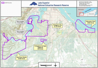
The Lake Superior National Estuarine Research Reserve includes land and water areas along the St. Louis River and Lake Superior in Douglas County, in the northwest corner of Wisconsin, United States. It is one of 29 National Estuarine Research Reserves. The Reserve is operated as a program of the Natural Resources Institute of the University of Wisconsin-Madison Division of Extension. It has an area of 16,697 acres (6,757 ha), and was designated in 2010.

<span class="mw-page-title-main">Alto Golfo de California Biosphere Reserve</span> UNESCO biosphere reserve in Sonora, Mexico

Alto Golfo de California Biosphere Reserve is a UNESCO Biosphere Reserve located in the state of Sonora in extreme northwestern Mexico. The 1,652,110 hectares (6,378.8 sq mi) reserve comprises the El Pinacate y Gran Desierto reserve and the Bahia Adair on the Gulf of California border. Geological volcanic formations with craters, dunes, oasis and beaches, and the diversity of plant associations determine its special landscape. The reserve was established in 1993 by the President of Mexico as Reserva de la Biosfera del Alto Golfo de California y Delta del Río Colorado and extended in 1995.

Vicky J. Meretsky is an American professor and Director of Environmental Masters Programs at Indiana University Bloomington.

References

  1. "Humedales del Delta del Río Colorado". Ramsar Sites Information Service. Retrieved 25 April 2018.
  2. Alles, David A., ed. (28 May 2005). "Geology of the Salton Trough" (PDF). Western Washington University.
  3. "Water, wildlife surge back into once-parched Colorado River delta". Los Angeles Times. 28 March 2014.
  4. "Science Plans RCL".
  5. James, Ian (23 June 2022). "Where Colorado River no longer meets the sea, a pulse of water brings new life". Los Angeles Times. Retrieved 24 June 2022.
  6. Pitt, Jennifer (2000). "Two nations, one river: Managing ecosystem conservation in the Colorado River Delta". Natural Resources Journal. 40: 819–864.
  7. Clifford, Frank (21 September 2007). "A trickle of water might save estuary". Los Angeles Times.
  8. Briggs, Mark K.; Cornelius, Steve. "Opportunities for ecological improvement along the lower Colorado River and delta". Wetlands. 18: 513–529. doi:10.1007/BF03161669.
  9. "As the Colorado River Basin Dries, Can an Accidental Oasis Survive?". Arizona Public Media, April 10, 2019
  10. "Only 12 vaquita porpoises remain, watchdog group reports". news.mongabay.com. Retrieved 10 April 2018.
  11. "Upper Gulf of California and Colorado River Delta Biosphere Reserve". Archived from the original on 8 April 2012. Retrieved 4 July 2010.
  12. "Salton Trough". earthobservatory.nasa.gov. 29 July 2013.