
The Los Angeles Aqueduct system, comprising the Los Angeles Aqueduct and the Second Los Angeles Aqueduct, is a water conveyance system, built and operated by the Los Angeles Department of Water and Power. The Owens Valley aqueduct was designed and built by the city's water department, at the time named The Bureau of Los Angeles Aqueduct, under the supervision of the department's Chief Engineer William Mulholland. The system delivers water from the Owens River in the Eastern Sierra Nevada Mountains to Los Angeles, California.

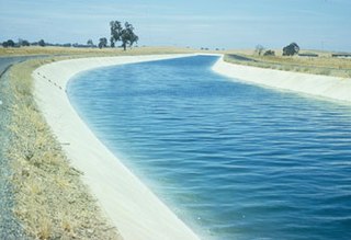
The Governor Edmund G. Brown California Aqueduct is a system of canals, tunnels, and pipelines that conveys water collected from the Sierra Nevada Mountains and valleys of Northern and Central California to Southern California. Named after California Governor Edmund Gerald "Pat" Brown Sr., the over 400-mile (640 km) aqueduct is the principal feature of the California State Water Project.

The Colorado River Aqueduct, or CRA, is a 242 mi (389 km) water conveyance in Southern California in the United States, operated by the Metropolitan Water District of Southern California (MWD). The aqueduct impounds water from the Colorado River at Lake Havasu on the California-Arizona border, west across the Mojave and Colorado deserts to the east side of the Santa Ana Mountains. It is one of the primary sources of drinking water for Southern California.

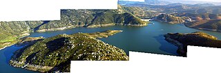
Diamond Valley Lake is a man-made off-stream reservoir located near Hemet, California, United States. It is one of the largest reservoirs in Southern California and also one of the newest. With a capacity of 800,000 acre-feet (990,000,000 m3), the lake nearly doubled the area's surface water storage capacity and provides additional water supplies for drought, peak summer, and emergency needs.
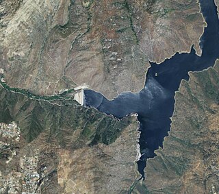
Parker Dam is a concrete arch-gravity dam that crosses the Colorado River 155 miles (249 km) downstream of Hoover Dam. Built between 1934 and 1938 by the Bureau of Reclamation, it is 320 feet (98 m) high, 235 feet (72 m) of which are below the riverbed (the deep excavation was necessary in order to reach the bedrock on which the foundation of the dam was built), making it the deepest dam in the world. The portion of the dam above the foundation stands 85 feet (25.9 m) tall, making it the only dam in the world that stands more underground than above ground. The dam's primary functions are to create a reservoir, and to generate hydroelectric power. The reservoir behind the dam is called Lake Havasu and can store 647,000 acre⋅ft (798,000,000 m3; 2.11×10¹¹ US gal; 1.76×10¹¹ imp gal). The dam straddles the Arizona-California state border at the narrows the river passes through between the Whipple Mountains in San Bernardino County, California and the Buckskin Mountains in La Paz County, Arizona.

The Metropolitan Water District of Southern California is a regional wholesaler and the largest supplier of treated water in the United States. The name is usually shortened to "Met," "Metropolitan," or "MWD." It is a cooperative of fourteen cities, eleven municipal water districts, and one county water authority, that provides water to 19 million people in a 5,200-square-mile (13,000 km2) service area. It was created by an act of the California Legislature in 1928, primarily to build and operate the Colorado River Aqueduct. Metropolitan became the first contractor to the State Water Project in 1960.
The Delta–Mendota Canal is a 117-mile-long (188 km) aqueduct in central California, United States. The canal was designed and completed in 1951 by the U.S. Bureau of Reclamation as part of the Central Valley Project. It carries freshwater to replace San Joaquin River water which is diverted into the Madera Canal and Friant-Kern Canal at Friant Dam.

San Luis Dam is a major earth-filled dam in Merced County, California, which forms San Luis Reservoir, the largest off-stream reservoir in the United States. The dam and reservoir are located in the Diablo Range to the east of Pacheco Pass and about 10 miles (16 km) west of Los Banos. San Luis Dam, a jointly-owned state and federal facility, stores more than 2 million acre feet (2.5 km3) of water for the California State Water Project and the federal Central Valley Project. Although the dam is located in the valley of San Luis Creek, the majority of its water comes from man-made aqueducts which are supplied from other rivers in Northern California.

The California State Water Project, commonly known as the SWP, is a state water management project in the U.S. state of California under the supervision of the California Department of Water Resources. The SWP is one of the largest public water and power utilities in the world, providing drinking water for more than 23 million people and generating an average of 6,500 GWh of hydroelectricity annually. However, as it is the largest single consumer of power in the state itself, it has a net usage of 5,100 GWh.

The New Waddell Dam is an embankment dam on the Agua Fria River in Maricopa County, Arizona, 35 miles (56 km) northwest of Phoenix. It serves as part of the Central Arizona Project (CAP) while also providing water for the Maricopa Water District. The dam creates Lake Pleasant with water from the Agua Fria and also the CAP aqueduct. In addition, it affords flood protection, hydroelectric power production and recreational opportunities. Construction on the dam began in 1985 and ended in 1994. Its reservoir submerged the Old Waddell Dam which was completed in 1927 after decades of planning.

The Otay River is a river in southern San Diego County, California. The 25 mi (40 km) river begins at San Miguel Mountain, flows through the Upper and Lower Otay Reservoirs, and continues on between the southern part of the Chula Vista and the Otay Mesa West district of San Diego, to its river mouth on San Diego Bay.

The Sweetwater River is a 55-mile (89 km) long stream in San Diego County, California.

The Eastern Municipal Water District of Southern California is a regional water district formed in 1950 to secure additional water for a largely rural area of western Riverside County. In addition to water service, responsibilities include sewage collection, water desalination and water recycling.
The Madera Canal is a 35.9 mi (57.8 km)-long aqueduct in the U.S. state of California. It is part of the Central Valley Project managed by the United States Bureau of Reclamation to convey water north to augment irrigation capacity in Madera County. It was also the subject of the United States Supreme Court's decision in Central Green Co. v. United States.
San Vicente Reservoir is a reservoir created by the San Vicente Dam in San Diego County, California. It is located in the Cuyamaca Mountains, approximately 4.3 miles (6.9 km) north of Lakeside off California State Route 67.

The Mokelumne Aqueduct is a 95-mile (153 km) water conveyance system in central California, United States. The aqueduct is supplied by the Mokelumne River and provides water to 35 municipalities in the East Bay in the San Francisco Bay Area. The aqueduct and the associated dams, pipelines, treatment plants and hydroelectric system are owned and operated by the East Bay Municipal Utility District (EBMUD) and provide over 90 percent of the water used by the agency.

The San Vicente Dam is a concrete gravity dam on San Vicente Creek near Lakeside and 25 km (15.5 mi) northeast of San Diego, California. The dam was built between 1941 and 1943 and created San Vicente Reservoir for the purpose of municipal water storage, flood control and recreation. Although the reservoir is fed by run-off, its main source is the First San Diego Aqueduct. In June 2009, construction to raise the height of the dam by 117 ft (36 m), in order to more than double its reservoir size, commenced. It is the largest dam raise in the United States and largest roller-compacted concrete dam raise in the world. The dam raise project was originally set for the end of 2012, but was completed in early 2014. Efforts to replace the water supply pipelines and prepare the reservoir for the public will be underway until 2015–2017.

The Olivenhain Dam is a gravity dam near Escondido, California. The dam was constructed between 1998 and 2003 as part of San Diego's Emergency Storage Project with the primary purpose of water supply for municipal use. It does not sit on a river or stream but is supplied with water by a system of pumps and pipes. The dam is connected to Lake Hodges and the Second San Diego Aqueduct. It is constructed of roller-compacted concrete and is the first of its type in California.
El Capitan Dam is an embankment dam on the San Diego River in southern California. The dam forms the 112,800-acre-foot (139,100,000 m3) El Capitan Reservoir and serves mainly to supply water to the city of San Diego as well as providing flood control. The dam is connected to the San Diego municipal water system via the El Capitan Pipeline, which extends approximately 30 miles (48 km) to the city. It is the second largest storage facility in San Diego's water supply system, after San Vicente Dam.

The San Juan–Chama Project is a U.S. Bureau of Reclamation interbasin water transfer project located in the states of New Mexico and Colorado in the United States. The project consists of a series of tunnels and diversions that take water from the drainage basin of the San Juan River – a tributary of the Colorado River – to supplement water resources in the Rio Grande watershed. The project furnishes water for irrigation and municipal water supply to cities along the Rio Grande including Albuquerque and Santa Fe.


