Sussex County, Delaware

Last updated

Sussex County
Sussex County Courthouse.jpg
Sussex County Courthouse in Georgetown
Flag of Sussex County, Delaware.svg
Sussex County Seal.jpg
Map of Delaware highlighting Sussex County.svg
Location within the U.S. state of Delaware
Delaware in United States.svg
Delaware's location within the U.S.
Coordinates: 38°41′N75°20′W / 38.68°N 75.34°W / 38.68; -75.34
CountryFlag of the United States.svg United States
StateFlag of Delaware.svg  Delaware
FoundedAugust 8, 1683
Named for Sussex, England
Seat Georgetown
Largest city Seaford
Area
  Total1,196 sq mi (3,100 km2)
  Land936 sq mi (2,420 km2)
  Water260 sq mi (700 km2)  21.7%
Population
 (2020)
  Total237,378
  Density253.61/sq mi (97.92/km2)
Time zone UTC−5 (Eastern)
  Summer (DST) UTC−4 (EDT)
Congressional district At-large
Website www.sussexcountyde.gov

Sussex County is located in the southern part of the U.S. state of Delaware, on the Delmarva Peninsula. As of the 2020 census, the population was 237,378, making it the state's second most populated county only behind New Castle and ahead of Kent. [1] The county seat is Georgetown. [2]

Contents

The first European settlement in the state of Delaware was founded by the Dutch in 1631 near the present-day town of Lewes on the Atlantic Coast. However, Sussex County was not organized until 1683 under English colonial rule.

Sussex County is included in the Salisbury, MD-DE metropolitan statistical area which encompasses much of central Delmarva.

History

Beginnings

Archaeologists estimate that the first inhabitants of Sussex County, the southernmost county in Delaware, arrived between 10,000 and 14,000 years ago. Various indigenous cultures occupied the area, especially along the river and the coast, often having seasonal fishing villages. Historic Native Americans in Sussex County were members of Algonquian-speaking tribes, as were most coastal peoples along the Atlantic Coast.

By the historic period of European encounter, the most prominent tribes in the area were the Lenape, whose territory extended through the mid-Atlantic states to Connecticut and the future New York metropolitan area, and Nanticoke tribes. The people settled along the numerous bodies of water in the area where they were able to harvest fish, oysters, and other shellfish in the fall and winter. In the warmer months the women planted and cultivated crops, and processed the food. The men hunted deer and other small mammals, as larger game was not present in the area. [3]

European discovery

There is no agreement on which European group was the first to settle in Sussex County. Historians believe that, in the early years of exploration from 1593 to 1630, Swedish explorers were likely the first Europeans to see the Delaware River and the lands of present-day Sussex County.[ citation needed ]

On an expedition for the Dutch West India Company, Henry Hudson recorded discovery in 1609 of what was later named the Delaware River. Attempting to follow him, Samuel Argall, an English explorer, was blown off course in 1610 and landed in a strange bay which he named after the Governor of Virginia, Thomas West, Lord De La Warr.

In the first half of 1613, Cornelius Jacobsen Mey, a Dutch navigator, discovered and named both Cape May and Cape Henlopen (originally Hindlopen) in the Delaware Bay. Later it was found that what May had named Henlopen was Fenwick Island, protruding into the Atlantic Ocean. The name of the cape was moved to its present location just east of Lewes.[ citation needed ]

European settlement

Sussex County was the site of the first European settlement in Delaware, a Dutch trading post named Zwaanendael at the present site of Lewes. On June 3, 1631, Dutch captain David Pietersen de Vries landed along the shores of the Delaware to establish a whaling colony in the mid-Atlantic of the New World. The colony lasted only until 1632, when De Vries left. Upon returning to Zwaanendael that December, he found the Indian tribes had killed his men and burned the colony. The Dutch set about settling the area once again. [4]

Although the Dutch and Swedes returned to resettle the Delaware River region as early as 1638, much of the Delaware Bay area south of what is today the city of Newcastle was not settled until 1662. At that time, the city of Amsterdam made a grant of land at the Hoernkills (the area around Cape Henlopen, near the current town of Lewes) to a party of Mennonites. A total of 35 men were to be included in the settlement, led by a Pieter Cornelisz Plockhoy of Zierikzee, and funded by a sizable loan from the city to get them established. This settlement, established in 1663, was organized in part by the Dutch to respond to threats from the English colony of Maryland to the west beginning to assert rights over the area. The English wrested control of New Netherland from the Dutch in 1664 and they destroyed the Mennonite settlement that same year; English reports indicated that “not even a nail” was left there. [5]

Settlement in the area after the English ejected the Dutch was slow. The Swedes and Finns who had settled in the area from the days of New Sweden had generally welcomed the English and were allowed to stay; the few Dutch found in the area were rounded up as prisoners and sent to Virginia as slaves. Lord Baltimore encouraged Marylanders to move east to settle the area. But the land was far removed from other, more established settlements and did not appeal to many new settlers. It was a tempting wilderness base for pirates to hide out from authorities and regularly pillage settlers for supplies.

The Dutch briefly recaptured the territory in 1673 as part of the Third Anglo-Dutch War. At that point, they established courts in the town of New Castle and at the Hoerkill at the southern end of the territory, effectively creating two counties out of the territory. After the war concluded in 1674, the Delaware territory was returned to the English. It was then placed under the control of James Stuart, Duke of York.

1683 Seal of Sussex County Seal of Sussex County Delaware 1683.jpg
1683 Seal of Sussex County

In 1680, the Duke reorganized the territory south of the Mispillion River as Deale County with the county seat at New Deale (modern-day Lewes); and created a third county, St. Jones, out of the Delaware territory between the Mispillion River and Duck Creek. In 1682, English King Charles II awarded the Delaware territories to William Penn in settlement of family debts, and Penn reorganized all three Delaware counties: Deale County become Sussex County, and St. Jones County became Kent County, in recognition of Penn's homelands in the county of Sussex, England. He brought 200 people from Sussex, England as colonists. [6] The town of New Deale was renamed Lewistown (today known as Lewes). At this time, Penn claimed that the Delaware territory extended as far south as Fenwick Island. The 'Three Lower Counties' (Delaware) along Delaware Bay were considered under Penn's sphere of settlement and became the Delaware Colony, a satellite of Pennsylvania.

But the boundary disputes continued between Pennsylvania and Maryland. Charles Calvert, 5th Baron Baltimore and William Penn both claimed the land between the 39th and 40th parallels, according to the charters granted to each colony. Whereas Penn claimed the Delaware territories extended to Fenwick Island, Calvert claimed the Maryland Colony ended at Lewes, with all the land south of the settlement belonging to Somerset County. [7]

In 1732 Charles Calvert signed a territorial agreement with William Penn's sons that drew a line somewhere in between the two colonies and renounced Calvert's claim to Delaware. But Lord Baltimore later claimed that the document he signed did not contain the terms he had agreed to, and refused to put the agreement into effect. Beginning in the mid-1730s, violence erupted between settlers claiming various loyalties to Maryland and Pennsylvania. The border conflict between Pennsylvania and Maryland would be known as Cresap's War.

In 1750–1751, a team of surveyors from both colonies surveyed and marked the Transpeninsular Line, which established the southern boundary of Sussex County. However, residents of the disputed territory continued to pay taxes to Maryland into the 1770s.

The issue was unresolved until the Crown intervened in 1760, ordering Frederick Calvert, 6th Baron Baltimore to accept the 1732 agreement. As part of the settlement, the Penns and Calverts commissioned the English team of Charles Mason and Jeremiah Dixon to survey the newly established boundaries between the Province of Pennsylvania, the Province of Maryland, Delaware Colony and parts of Colony and Old Dominion of Virginia.

Between 1763 and 1767, Charles Mason and Jeremiah Dixon surveyed the Mason-Dixon line, settling Sussex County's western borders. After Pennsylvania abolished slavery in 1781, the western part of this line and the Ohio River became a border between free and slave states. Although Delaware remained a slave state, it already had a number of free blacks, and slaveholders manumitted more slaves in the first two decades after the Revolution.

The resolution of the boundary dispute enlarged Sussex County considerably, and the new territory was nicknamed New Sussex.

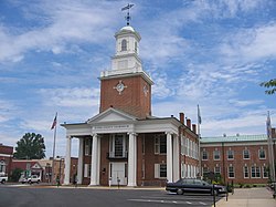
In 1769 a movement started to move the county seat from Lewes to the area then known as Cross Roads, the present day site of Milton. The current county seat of Georgetown was settled upon on January 27, 1791, after residents in western Sussex County successfully petitioned the Delaware General Assembly to move the county seat to a central location, as the limited roads at the time made it too difficult for outlying residents to reach the county seat in Lewes. [8]

Georgetown was not a previously established town. On May 9, 1791, the 10 commissioners headed by President of the State Senate George Mitchell negotiated the purchase of 76 acres (310,000 m2), and Commissioner Rhodes Shankland began the survey by laying out "a spacious square of 100 yards (91 m) each way." Eventually the town was laid out in a circle one mile (1.6 km) across. It was centered on the original square surveyed by Shankland, which is now listed on the National Register of Historic Places. Georgetown was named after Senate President George Mitchell. [9]

Sussex County has been known by several names over the years, including Susan County, Hoorenkill or Whorekill County as named by the Dutch prior to 1680 when Kent County broke off. From 1680 to 1682 it was known as Deale County, after being taken over by the British under James Stuart, Duke of York prior to signing over to William Penn. It was called Durham County when claimed by the Lords Baltimore during the boundary dispute with the Penn family. [10]

Geography

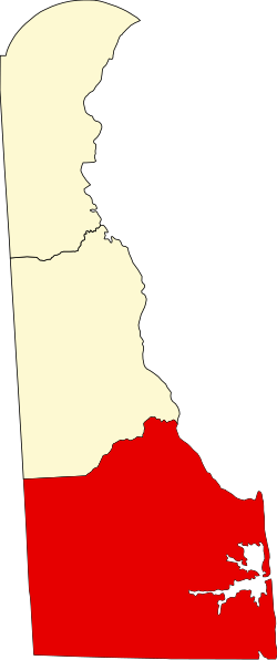
According to the U.S. Census Bureau, the county has a total area of 1,196 square miles (3,100 km2), of which 936 square miles (2,420 km2) is land and 260 square miles (670 km2) (21.7%) is water. [11] It is the largest county in Delaware by area. The county's land area comprises 48.0 percent of the state's land area. It is the second-highest percentage of territory of a state of any county in the United States.

Sussex County, like Delaware's two other counties, is subdivided into Hundreds. There are several explanations given for how the Hundreds were determined: as an area containing 100 families, an area containing 100 people, or an area that could raise 100 soldiers. [12] Sussex County is apportioned into eleven Hundreds: Cedar Creek, Broadkill, Georgetown, Nanticoke, Northwest Fork, Broad Creek, Little Creek, Dagsboro, Baltimore, Indian River, and Lewes & Rehoboth.

The eastern portion of the county is home to Delaware's beaches on the Atlantic Coast and many seaside resorts. The western side of the county is the center of Delaware's agriculture, industry with more acres of arable land under cultivation than anywhere else in the state.[ citation needed ]

Cluster of bald cypress trees seen in Trap Pond State Park Bald Cypress.JPG
Cluster of bald cypress trees seen in Trap Pond State Park

Sussex County is home to an extensive system of Southern saltwater and freshwater wetlands, notably the Great Cypress Swamp. This massive freshwater swamp contains the northernmost strand of Bald Cypress trees in the United States. [13] In addition, Zigzag Swamp is located within Sussex County. [14]

Prime Hook National Wildlife Refuge is a 10,000 acres (40 km2) along the western shore of Delaware Bay. The refuge contains a variety of habitats, including freshwater and salt marshes, woodlands, grasslands, ponds, and forested areas, supporting 267 species of birds and a variety of reptiles, amphibians and mammals. [15]

Adjacent counties

Major highways

DE 1 in Milford, northern Sussex County 2022-07-14 15 38 10 View north along Delaware State Route 1 (Coastal Highway) from the overpass for northbound Delaware State Route 1 Business (Rehoboth Boulevard) in Milford, Sussex County, Delaware.jpg
DE 1 in Milford, northern Sussex County

National protected area

Climate

Sussex County has a humid subtropical climate (Cfa) according to the Köppen climate classification. The Trewartha climate classification only has the area along the Atlantic Coast up to Cape Henlopen and Lewes as Cf and the remainder of the county as Do (oceanic.) Three months average above 22°C (71.6°F), all months average above freezing, and seven to eight months average above 10 °C (50 °F). The hardiness zone is 7b except near the coast where it is 8a.

Climate data for Milford, Delaware
MonthJanFebMarAprMayJunJulAugSepOctNovDecYear
Record high °F (°C)79
(26)
78
(26)
90
(32)
97
(36)
99
(37)
102
(39)
106
(41)
103
(39)
99
(37)
95
(35)
86
(30)
76
(24)
106
(41)
Mean daily maximum °F (°C)43
(6)
45
(7)
54
(12)
64
(18)
73
(23)
82
(28)
87
(31)
85
(29)
78
(26)
68
(20)
58
(14)
48
(9)
65
(19)
Mean daily minimum °F (°C)24
(−4)
25
(−4)
33
(1)
42
(6)
52
(11)
62
(17)
67
(19)
65
(18)
57
(14)
46
(8)
36
(2)
29
(−2)
45
(7)
Record low °F (°C)−11
(−24)
−11
(−24)
4
(−16)
16
(−9)
28
(−2)
36
(2)
39
(4)
43
(6)
34
(1)
19
(−7)
9
(−13)
−2
(−19)
−11
(−24)
Average precipitation inches (mm)4.08
(104)
3.30
(84)
4.51
(115)
3.50
(89)
4.03
(102)
3.31
(84)
3.69
(94)
4.61
(117)
4.08
(104)
3.48
(88)
3.32
(84)
3.59
(91)
45.50
(1,156)
Average snowfall inches (cm)3.9
(9.9)
5.4
(14)
0.9
(2.3)
0.1
(0.25)
0
(0)
0
(0)
0
(0)
0
(0)
0
(0)
0
(0)
0.2
(0.51)
1.5
(3.8)
12
(30.76)
Source: [16]
Climate data for Bethany Beach, Delaware
MonthJanFebMarAprMayJunJulAugSepOctNovDecYear
Record high °F (°C)78
(26)
86
(30)
89
(32)
92
(33)
97
(36)
102
(39)
101
(38)
101
(38)
98
(37)
92
(33)
88
(31)
77
(25)
102
(39)
Mean daily maximum °F (°C)45
(7)
48
(9)
55
(13)
65
(18)
74
(23)
83
(28)
87
(31)
85
(29)
79
(26)
69
(21)
59
(15)
49
(9)
67
(19)
Mean daily minimum °F (°C)30
(−1)
31
(−1)
37
(3)
46
(8)
55
(13)
65
(18)
70
(21)
69
(21)
63
(17)
52
(11)
43
(6)
34
(1)
50
(10)
Record low °F (°C)−11
(−24)
0
(−18)
9
(−13)
18
(−8)
32
(0)
40
(4)
47
(8)
47
(8)
37
(3)
26
(−3)
16
(−9)
0
(−18)
−11
(−24)
Average precipitation inches (mm)3.62
(92)
3.23
(82)
4.40
(112)
3.59
(91)
3.72
(94)
3.39
(86)
4.78
(121)
4.73
(120)
4.04
(103)
3.94
(100)
3.66
(93)
3.85
(98)
46.95
(1,192)
Average snowfall inches (cm)5.5
(14)
6.2
(16)
2.1
(5.3)
0.2
(0.51)
0
(0)
0
(0)
0
(0)
0
(0)
0
(0)
0
(0)
0.6
(1.5)
2.2
(5.6)
16.8
(42.91)
Source 1: The Weather Channel [17]
Source 2: MyForecast [18]

Government

Unlike Northern Delaware, particularly New Castle County, Sussex County is highly conservative. Sussex County has only supported a Democrat for president three times since 1944.

This was the only county in Delaware that Barack Obama did not carry in either of his presidential bids, despite the presence of Delawarean Joe Biden on the ballot. Biden himself lost the county by 11 points in his own successful bid for president in 2020. Nonetheless, while Sussex County rejected the Obama-Biden presidential ticket in 2008, Biden carried it in his simultaneous 2008 Senate run (as he did in six of his seven successful Senate campaigns), meaning some voters in this county rejected Biden as a vice presidential candidate while simultaneously supporting him for Senate.

The county's Republican bent is no less pronounced at the state level. Republicans hold every seat on the county council and every elected county office. Republicans also hold all four of the five state senate seats and seven of the nine state house seat within the county.

United States presidential election results for Sussex County, Delaware [19]
Year Republican Democratic Third party
No.%No.%No.%
2020 71,23055.07%56,68243.82%1,4401.11%
2016 62,61159.01%39,33337.07%4,1623.92%
2012 52,11955.90%39,97542.88%1,1351.22%
2008 47,93953.82%40,29945.24%8320.93%
2004 47,00360.45%30,09838.71%6510.84%
2000 34,62052.23%29,73944.86%1,9282.91%
1996 22,18742.66%23,19144.59%6,63412.75%
1992 20,44038.89%19,17436.48%12,95124.64%
1988 27,12961.97%16,50437.70%1420.32%
1984 28,33767.32%13,62932.38%1260.30%
1980 19,47252.09%15,97342.73%1,9345.17%
1976 17,15347.56%18,55251.44%3631.01%
1972 21,96464.59%11,63034.20%4101.21%
1968 15,61847.23%11,67135.30%5,77717.47%
1964 14,30544.19%17,97155.51%970.30%
1960 16,39251.08%15,47248.21%2290.71%
1956 16,62154.62%13,69745.01%1120.37%
1952 17,25753.06%15,05446.29%2100.65%
1948 13,63653.94%11,52245.57%1240.49%
1944 11,89552.53%10,67847.15%730.32%
1940 11,85347.30%13,20652.70%00.00%
1936 11,99648.31%12,79951.54%370.15%
1932 10,63245.63%12,61854.15%520.22%
1928 12,88464.10%7,16335.64%540.27%
1924 10,12053.23%8,66845.59%2251.18%
1920 9,74753.57%8,44846.43%00.00%
1916 6,03251.36%5,64948.10%640.54%
1912 4,46639.26%5,55148.80%1,35711.93%
1908 5,87053.25%5,01345.48%1401.27%
1904 5,91556.48%4,40742.08%1511.44%
1900 4,96152.45%4,36446.14%1331.41%
1896 4,54152.88%3,82644.55%2212.57%
1892 4,14748.64%4,27950.19%1001.17%
1888 4,04649.71%3,98248.92%1111.36%
1884 3,01840.37%4,44759.49%100.13%
1880 3,37345.28%3,99353.60%831.11%
1876 2,76344.19%3,49055.81%00.00%
1872 2,84948.32%2,77847.12%2694.56%
1868 1,88337.52%3,13662.48%00.00%
1864 2,22946.62%2,55253.38%00.00%
1860 66414.14%2044.34%3,82981.52%
1856 10.02%2,34453.70%2,02046.28%
1852 1,93451.00%1,85849.00%00.00%
1848 1,85249.95%1,85650.05%00.00%
1844 1,86949.89%1,87750.11%00.00%
1840 2,05356.31%1,59343.69%00.00%
1836 1,85758.82%1,30041.18%00.00%

Sussex County's government is composed of an elected county council and various elective executive heads of departments. The county council has five members, who serve four-year terms; all are elected from single-member districts. They form the legislative authority of the county, and choose a "County Administrator" or executive.

The county council members are Council President Michael H. Vincent (R, District 1), Cynthia Green (R, District 2), Mark Schaeffer (R, District 3), Douglas B. Hudson (R, District 4), and Vice President John L. Rieley (R, District 5). [20]

The additional offices of Clerk of the Peace, Register of Deeds, Register of Wills and Sheriff are elected at-large. [21] These positions are held by Norman A. Jones Jr. (R), Alexandra Reed Baker (R), Gregory Fuller (R), and Robert Lee (R), respectively. [22]

Sussex County is split between five state senate districts and nine state house districts.

State Senate:

State House of Representatives:

Demographics

Historical population
CensusPop.Note
1790 20,488
1800 19,358−5.5%
1810 27,75043.4%
1820 24,057−13.3%
1830 27,11512.7%
1840 25,093−7.5%
1850 25,9363.4%
1860 29,61514.2%
1870 31,6967.0%
1880 36,01813.6%
1890 38,6477.3%
1900 42,2769.4%
1910 46,4139.8%
1920 43,741−5.8%
1930 45,5074.0%
1940 52,50215.4%
1950 61,33616.8%
1960 73,19519.3%
1970 80,3569.8%
1980 98,00422.0%
1990 113,22915.5%
2000 156,63838.3%
2010 197,14525.9%
2020 237,37820.4%
2023 (est.)263,509 [23] 11.0%
U.S. Decennial Census [24]
1790-1960 [25] 1900-1990 [26]
1990-2000 [27] 2010-2020 [1]


2000 census

As of the census of 2000, there were 156,638 people, 62,577 households, and 43,866 families residing in the county. The population density was 167 inhabitants per square mile (64/km2). There were 93,070 housing units at an average density of 99 per square mile (38/km2). The racial makeup of the county was 80.35% White, 14.89% Black or African American, 0.60% Native American, 0.75% Asian, 0.04% Pacific Islander, 2.02% from other races, and 1.35% from two or more races. 4.41% of the population were Hispanic or Latino of any race. 14.9% were of English, 14.3% United States or American (Mostly British), 12.9% Irish, 12.5% German and 5.6% Italian ancestry, 93.3% spoke English and 4.3% Spanish as their first language.

There were 62,577 households, out of which 27.10% had children under the age of 18 living with them, 54.90% were married couples living together, 11.30% had a female householder with no husband present, and 29.90% were non-families. 24.30% of all households were made up of individuals, and 11.10% had someone living alone who was 65 years of age or older. The average household size was 2.45 and the average family size was 2.88.

In the county, the population was spread out, with 22.50% under the age of 18, 7.00% from 18 to 24, 26.30% from 25 to 44, 25.60% from 45 to 64, and 18.50% who were 65 years of age or older. The median age was 41 years. For every 100 females, there were 95.50 males. For every 100 females age 18 and over, there were 92.80 males.

The median income for a household in the county was $39,208, and the median income for a family was $45,203. Males had a median income of $30,811 versus $23,625 for females. The per capita income for the county was $20,328. About 7.70% of families and 10.50% of the population were below the poverty line, including 15.00% of those under age 18 and 8.40% of those age 65 or over.

Eastern parts of Sussex County, particularly the Cape Region, tend to be more affluent than western portions of the county, with a median household income of $77,030 in 2009. [28]

2010 census

As of the 2010 census, there were 197,145 people, 79,368 households, and 53,698 families residing in the county. [29] The population density was 210.6 inhabitants per square mile (81.3/km2). There were 123,036 housing units at an average density of 131.4 per square mile (50.7/km2). [30] The racial makeup of the county was 79.0% white, 12.7% black or African American, 1.0% Asian, 0.8% American Indian, 0.1% Pacific islander, 4.1% from other races, and 2.3% from two or more races. Those of Hispanic or Latino origin made up 8.6% of the population. [29] In terms of ancestry, 17.9% were Irish, 17.8% were German, 15.9% were English, 7.0% were Italian, and 6.2% were American. [31]

Of the 79,368 households, 27.0% had children under the age of 18 living with them, 51.3% were married couples living together, 11.7% had a female householder with no husband present, 32.3% were non-families, and 25.6% of all households were made up of individuals. The average household size was 2.45 and the average family size was 2.89. The median age was 45.4 years. [29]

The median income for a household in the county was $51,046 and the median income for a family was $59,053. Males had a median income of $41,978 versus $32,148 for females. The per capita income for the county was $26,779. About 8.0% of families and 11.7% of the population were below the poverty line, including 20.4% of those under age 18 and 6.5% of those age 65 or over. [32]

2020-2021 census and census estimates

As of the 2020 census, the county had a population of 237,378. According to the 2021 American Community Survey, the racial and ethnic makeup of the county was 75.4% non-Hispanic white, 11.8% Black or African American, 1.1% Native American, 1.4% Asian, 0.2% Pacific Islander, 2.3% multiracial, and 9.6% Hispanic or Latino of any race. [1]

Economy

Cornfields seen near Lewes Corn in Lewes.JPG
Cornfields seen near Lewes

Most of Sussex County's economy revolves around agriculture. In fact, Sussex County produces the most poultry of any county in the United States. [33] [34]

Tourism also plays a large part of the economy, particularly in eastern Sussex County. According to SeaGrant Delaware, the Delaware Beaches generate $6.9 billion annually and over $711 million in tax revenue. [35]

The average home and property price in Sussex County increased 250% in the ten years between 1995 and 2005. Local increases within Sussex County for this period include a 381% increase for Millsboro and a 609% increase for Millville. [36] Sussex County is served by the Delmarva Central Railroad and the Maryland and Delaware Railroad. [37]

Education

Public

Sussex County is served by eight public school districts. [38] [39]

The county also contains one charter school, the Sussex Academy of Arts & Sciences. [40]

Those state funded public high schools which participate in sporting events are members of the Henlopen Conference. [41]

Private

There are several private schools in Sussex County: Bible Center Christian Academy (Laurel), Children Craft CO (Seaford), Delmarva Christian High School (Georgetown, Destiny Christian School (Georgetown), Eagle's Nest Christian School (Milton), Epworth Christian School (Laurel), Greenwood Mennonite School (Greenwood), Harbor Christian Academy (Ellendale), The Jefferson School (Georgetown), Jesus Is Lord Christian Academy (Georgetown), Lighthouse Christian School (Dagsboro), Lighted Pathway Christian Academy (Seaford), Milford Christian School (Milford) and Seaford Christian Academy (Seaford). [42]

Higher education

There are several colleges and universities in Sussex County. Delaware Technical Community College has the largest presence in the county, but students can also attend Delaware State University, Goldey-Beacom College, University of Delaware all in Georgetown, the Philadelphia Bible College in Ellendale, and the Beebe Hospital School of Nursing in Lewes. The University of Delaware also maintains a marine science campus in Lewes.

Culture

The culture in Sussex County is much like that found in other Delmarva counties. Sussex County is starkly different from the rest of the Mid-Atlantic and is much like that of the Southern United States. Sussex County is driven by agriculture and commercial fishing. [43] Most of the land is rural and there are but a few large population centers. Many local restaurants serve southern cuisine such as sweet tea and dishes including or composed entirely of greens in addition to menus heavy with fried food.[ citation needed ]

Many dialectic studies show that Sussex County residents, much like surrounding Delmarva counties, have a variation of Southern American English which is particularly prevalent in rural areas. [44]

Festivals, fairs, and events

Sussex County, Delaware is home to several festivals, fairs, and events. Some of the more notable festivals are the Bethany Beach Jazz Funeral to mark the end of summer, Apple Scrapple Festival in Bridgeville, the Return Day Parade held after elections in even-numbered years in Georgetown, the Laurel Independence Day Celebration, the Nanticoke Indian Pow Wow in Oak Orchard, the Rehoboth Beach Chocolate Festival, the Rehoboth Beach Independent Film Festival, the Rehoboth Beach Jazz Festival, the Sea Witch Halloween Festival and Parade in Rehoboth Beach, and Seaford Riverfest. Also, Sussex County is the home of the Senior League Softball World Series in Roxana at the Lower Sussex Little League Field. The World Championship Punkin Chunkin was held in Sussex County.

Media

Newspapers

Radio

Call signFrequencyCity of license [45] [46] Owner [47] Format [47] [48]
WUSX 98.5 FMSeaford Adams Radio Group Country
WGMD 92.7 FMRehoboth BeachResort Broadcasting Co., LLCNews Talk Information
WJKI-FM 103.5 FMBethany BeachThe Voice Radio, LLCClassic Rock
WJWL 900 AMGeorgetownGreat Scott BroadcastingSpanish Variety
WKDB 95.3 FMLaurelGreat Scott BroadcastingContemporary Hit Radio
WOCM 98.1 FMSelbyvilleIrie Radio, Inc.Album Adult Alternative
WRBG-LP 106.5 FMMillsboroRhythm and Blues Group Harmonty Association, Inc.
WSUX 1280 AMSeafordGreat Scott BroadcastingSpanish Variety
WZBH 93.5 FMGeorgetown Adams Radio Group Active Rock
WZEB 101.7 FMOcean ViewGreat Scott BroadcastingContemporary Hit Radio
WXDE 105.9 FMLewesDelmarva Broadcasting CompanyNews Talk

Television

Communities

Lighthouse off the coast of Lewes Harbor of Refuge.JPG
Lighthouse off the coast of Lewes
Rehoboth Beach Rehoboth Beach boardwalk looking north toward Rehoboth Avenue.jpg
Rehoboth Beach
Seaford High Street, Seaford, Delaware (2006).jpg
Seaford
Selbyville Public Library Selbyville Library.jpg
Selbyville Public Library

Cities

Towns

Unincorporated communities

See also

Related Research Articles

<span class="mw-page-title-main">Delaware</span> U.S. state

Delaware is a state in the Mid-Atlantic region of the United States. It borders Maryland to its south and west, Pennsylvania to its north, New Jersey to its northeast, and the Atlantic Ocean to its east. The state's name derives from the adjacent Delaware Bay, which in turn was named after Thomas West, 3rd Baron De La Warr, an English nobleman and the Colony of Virginia's first colonial-era governor.

<span class="mw-page-title-main">Delmarva Peninsula</span> Large peninsula on the East Coast of the US

The Delmarva Peninsula, or simply Delmarva, is a large peninsula on the East Coast of the United States, occupied by the vast majority of the state of Delaware and parts of the Eastern Shore of Maryland and Eastern Shore of Virginia.

<span class="mw-page-title-main">Lewes, Delaware</span> City in Delaware, United States

Lewes is an incorporated city on the Delaware Bay in eastern Sussex County, Delaware, United States. According to the 2020 census, its population was 3,303. Along with neighboring Rehoboth Beach, Lewes is one of the principal cities of Delaware's rapidly growing Cape Region. The city lies within the Salisbury, Maryland–Delaware Metropolitan Statistical Area. Lewes proudly claims to be "The First Town in The First State."

<span class="mw-page-title-main">Milford, Delaware</span> City in Delaware, United States

Milford is a city in Kent and Sussex counties in the U.S. state of Delaware. According to the 2020 census, the population of the city is 11,190 people and 4,356 households in the city.

<span class="mw-page-title-main">Blades, Delaware</span> Town in Delaware, United States

Blades is a town in Sussex County, Delaware, United States. As of the 2010 census, the town population was 1,241, a 29.8% increase over the previous decade. It is part of the Salisbury, Maryland-Delaware Metropolitan Statistical Area.

<span class="mw-page-title-main">Bridgeville, Delaware</span> Town in Delaware, United States

Bridgeville is a town in Sussex County, Delaware, United States. According to the 2020 census, the population is 2,568. It is part of the Salisbury, Maryland-Delaware Metropolitan Statistical Area.

<span class="mw-page-title-main">Dewey Beach, Delaware</span> Town in Delaware, United States

Dewey Beach is an incorporated coastal town in eastern Sussex County, Delaware, United States. According to the 2010 census, the population of the town is 341, an increase of 13.3% over the previous decade. It is part of the rapidly growing Cape Region and lies within the Salisbury, Maryland-Delaware Metropolitan Statistical Area. In 2011, the NRDC awarded Dewey Beach with a 5-Star rating in water quality. This award was given only to 12 other locations, one being neighboring Rehoboth Beach. Out of the 30 states with coastline, the Delaware Beaches ranked number 1 in water quality in 2011.

<span class="mw-page-title-main">Ellendale, Delaware</span> Town in Delaware, United States

Ellendale is a town in Sussex County, Delaware, United States. The population was 487 at the 2020 census, an increase of 27.8% since the 2010 census, and a 48.9% increase since the year 2000. It is part of the Salisbury, Maryland-Delaware Metropolitan Statistical Area. Ellendale is the "Gateway to Delaware's Resort Beaches" because it is the town located on U.S. Route 113, the resort area's westernmost border, and Delaware Route 16, the resort area's northernmost border with the eastern border being the Delaware Bay and Atlantic Ocean and the southern border being the state line with Maryland.

<span class="mw-page-title-main">Fenwick Island, Delaware</span> Town in Delaware, United States

Fenwick Island is a coastal resort town in Sussex County, Delaware, United States. According to 2020 census figures, the population of the town is 355, a 2.6% decrease over the last decade. It is part of the Salisbury, Maryland–Delaware Metropolitan Statistical Area. The town is located on Fenwick Island, a barrier spit.

<span class="mw-page-title-main">Georgetown, Delaware</span> Town and county seat in Delaware, US

Georgetown is a town and the county seat of Sussex County, Delaware, United States. According to the 2010 census, the population of the town is 6,422, an increase of 38.3% over the previous decade.

<span class="mw-page-title-main">Henlopen Acres, Delaware</span> Town in Delaware, United States

Henlopen Acres is a municipality north of Rehoboth Beach in Sussex County, Delaware, United States, and is the third smallest incorporated town in Delaware. According to 2010 census figures, the population of the town is 122, a 12.2% decrease from the 2000 census. It is part of the Salisbury, Maryland-Delaware Metropolitan Statistical Area.

<span class="mw-page-title-main">Milton, Delaware</span> Town in Delaware, United States

Milton is a town in Sussex County, Delaware, United States, on the Delmarva Peninsula. It is located on the Broadkill River, which empties into Delaware Bay. The population was 3,291 at the 2020 census.

<span class="mw-page-title-main">Rehoboth Beach, Delaware</span> City in Delaware, United States

Rehoboth Beach is a city on the Atlantic Ocean along the Delaware Beaches in eastern Sussex County, Delaware, United States. As of 2020, its population was 1,108. Along with the neighboring coastal town of Lewes, Rehoboth Beach is one of the principal cities of Delaware's rapidly growing Cape Region. Rehoboth Beach lies within the Salisbury metropolitan area.

<span class="mw-page-title-main">Seaford, Delaware</span> City in Delaware, United States

Seaford is a city located along the Nanticoke River in Sussex County, Delaware, United States. According to the 2010 Census Bureau figures, the population of the city is 6,928, an increase of 3.4% from the 2000 census. It is part of the Salisbury, Maryland-Delaware Metropolitan Statistical Area.

<span class="mw-page-title-main">Cape Henlopen School District</span> School district in Sussex County, Delaware, United States.

The Cape Henlopen School District (CHSD) is a public school district in Sussex County, Delaware in the United States. The district is based in an unincorporated area with a Lewes postal address, and serves the Cape Region in eastern Sussex County.

<span class="mw-page-title-main">Queen Anne's Railroad</span> Defunct railroad in Maryland and Delaware, US

The Queen Anne’s Railroad was a railroad that ran between Love Point, Maryland, and Lewes, Delaware, with connections to Baltimore via ferry across the Chesapeake Bay. The Queen Anne's Railroad company was formed in Maryland in 1894, and received legislative authorization from Delaware in February 1895. The railroad's original western terminus was in Queenstown, Maryland, and was moved via a 13-mile (21 km) extension to Love Point in 1902, which shortened the ferry trip to Baltimore.

The Henlopen Conference is a high school sports conference comprising public schools in Kent County and Sussex County in lower Delaware. The teams participate in a variety of sports including football, boys and girls soccer, track and field, cross country, boys and girls basketball, boys and girls indoor track, boys and girls outdoor track, wrestling, boys and girls lacrosse, baseball, softball, cheerleading, boys and girls swimming, and field hockey.

The Salisbury, MD-DE Metropolitan Statistical Area is a United States Census Bureau-designated metropolitan area centered in and around Salisbury, Maryland, including four counties: Somerset, Wicomico, and Worcester in Maryland; and Sussex in Delaware.

The Delaware Coast Line Railroad was a short-line railroad located in Sussex County, Delaware. The company operated two lines on track owned by the State of Delaware: one running from Ellendale east to Milton and another running from Georgetown east to Cool Spring. The railroad interchanged with the Delmarva Central Railroad in Ellendale and Georgetown. It was owned by Dan Herholdt. Part of the rail lines were taken over by the Delmarva Central railroad.

<span class="mw-page-title-main">Cape Region (Delaware)</span> Region in Delaware, United States

The Cape Henlopen Region, or the Cape Region, is a region in Sussex County, in southern Delaware, on the Delmarva Peninsula. The region is part of the Salisbury, Maryland-Delaware Metropolitan Statistical Area. The region takes its name from Cape Henlopen, as does the Cape Henlopen School District and Cape Henlopen State Park. Much of the region's populated areas are found along the Delaware Bay, Rehoboth Bay and the Atlantic Ocean. Northern and western parts of the Cape Region are rural areas dominated by farmland and wetlands. The area is often referred to as the Delaware Beaches.

References

  1. 1 2 3 "State & County QuickFacts". United States Census Bureau. Archived from the original on July 17, 2011. Retrieved June 12, 2014.
  2. "Find a County". National Association of Counties. Archived from the original on December 26, 2018. Retrieved June 7, 2011.
  3. Harold B. Hancock (1976). The History of Sussex County, Delaware. pp. 1, 2.
  4. Hancock, pp 12-13.
  5. [Scharf, Thomas J., History of Delaware, 1609 – 1888, 1888
  6. Lower, Mark Antony (1865). Worthies of Sussex: Biographical sketches of the most eminent natives or inhabitants of the county. Lewes: Sussex Advertiser. p. 341.
  7. Sussex County, Delaware: USGenWeb Project [ permanent dead link ]
  8. Sussex County – History Archived October 22, 2007, at the Wayback Machine
  9. "At The Beach-Georgetown, Delaware History". Archived from the original on March 31, 2008. Retrieved March 13, 2008.
  10. "Sussex County, Delaware Genealogical Records Information". Archived from the original on September 4, 2012. Retrieved March 13, 2008.{{cite web}}: CS1 maint: bot: original URL status unknown (link)
  11. "US Gazetteer files: 2010, 2000, and 1990". United States Census Bureau. February 12, 2011. Archived from the original on August 24, 2019. Retrieved April 23, 2011.
  12. "Delaware History Online - Geography - Hundreds". Archived from the original on July 16, 2012. Retrieved July 29, 2012.
  13. "Trap Pond State Park, Laurel, Delaware". www.destateparks.com. Archived from the original on June 16, 2018. Retrieved June 9, 2018.
  14. U.S. Geological Survey Geographic Names Information System: Sussex County, Delaware
  15. U.S. Fish and Wildlife Service (FWS). "Prime Hook National Wildlife Refuge: Welcome." Archived July 14, 2016, at the Wayback Machine January 3, 2011.
  16. "Milford, DE Monthly Weather Averages" . Retrieved August 18, 2020.
  17. "Climate Statistics for Bethany Beach, Delaware" . Retrieved March 8, 2018.
  18. "Bethany Beach, DE climate" . Retrieved August 17, 2020.
  19. "Dave Leip's Atlas of United States Presidential Elections". Archived from the original on September 19, 2019. Retrieved June 11, 2011.
  20. "Sussex County Council". sussexcountyde.gov. Retrieved April 8, 2023.
  21. "Sussex County – Government Structure". Sussex County Council. Archived from the original on October 26, 2006. Retrieved December 16, 2006.
  22. "Sussex County Government". sussexcountyde.gov. Retrieved April 8, 2023.
  23. "Annual Estimates of the Resident Population for Counties: April 1, 2020 to July 1, 2023". United States Census Bureau. Retrieved March 31, 2024.
  24. "U.S. Decennial Census". United States Census Bureau. Archived from the original on April 26, 2015. Retrieved June 12, 2014.
  25. "Historical Census Browser". University of Virginia Library. Archived from the original on August 11, 2012. Retrieved June 12, 2014.
  26. "Population of Counties by Decennial Census: 1900 to 1990". United States Census Bureau. Archived from the original on February 18, 2014. Retrieved June 12, 2014.
  27. "Census 2000 PHC-T-4. Ranking Tables for Counties: 1990 and 2000" (PDF). United States Census Bureau. Archived (PDF) from the original on December 18, 2014. Retrieved June 12, 2014.
  28. "U.S. Census Bureau Home Page". Archived from the original on December 27, 1996. Retrieved May 8, 2017.
  29. 1 2 3 "DP-1 Profile of General Population and Housing Characteristics: 2010 Demographic Profile Data". United States Census Bureau. Archived from the original on February 13, 2020. Retrieved January 12, 2016.
  30. "Population, Housing Units, Area, and Density: 2010 - County". United States Census Bureau. Archived from the original on February 13, 2020. Retrieved January 12, 2016.
  31. "DP02 SELECTED SOCIAL CHARACTERISTICS IN THE UNITED STATES – 2006-2010 American Community Survey 5-Year Estimates". United States Census Bureau. Archived from the original on February 13, 2020. Retrieved January 12, 2016.
  32. "DP03 SELECTED ECONOMIC CHARACTERISTICS – 2006-2010 American Community Survey 5-Year Estimates". United States Census Bureau. Archived from the original on February 13, 2020. Retrieved January 12, 2016.
  33. Cohen, Micah (August 31, 2012). "Delaware: A Small Example of a Larger Trend". FiveThirtyEight . Archived from the original on September 5, 2012. Retrieved September 5, 2012.
  34. "Community Data" (PDF). Sussex County. September 2012. Archived from the original (PDF) on June 17, 2012. Retrieved September 5, 2012.
  35. "The Contribution of The Coastal Economy To The State of Delaware". SeaGrant Delaware. Archived from the original on April 2, 2017. Retrieved April 1, 2017.
  36. Mike Chalmers (May 22, 2006). "Looking to live in Sussex? Good luck". The News Journal . pp. A1, A6. Archived from the original on September 30, 2007.
  37. "Delmarva Central Railroad". Carload Express. November 8, 2016. Archived from the original on May 24, 2017. Retrieved March 27, 2017.
  38. "Delaware Public School Districts for K-12 Education". Delaware Educational Directory. Delaware Department of Education. Archived from the original on November 11, 2007. Retrieved March 11, 2008.
  39. "2020 CENSUS - SCHOOL DISTRICT REFERENCE MAP: Sussex County, DE" (PDF). U.S. Census Bureau. Archived (PDF) from the original on October 9, 2022. Retrieved July 20, 2022. - Text list - This list only includes the seven geographical school districts and does not include the county-wide overlay school district.
  40. Department of Education (2010–2011). "List of Delaware Charter Schools". State of Delaware. Archived from the original on September 17, 2010. Retrieved September 14, 2010.
  41. "Sussex County, Delaware: History and Information". www.ereferencedesk.com. Archived from the original on February 7, 2018. Retrieved February 6, 2018.
  42. "Sussex County, Delaware Private Schools". Archived from the original on September 3, 2007. Retrieved December 19, 2007.
  43. Jones, Pattrice (January 1, 2009). "Let the diversification of Delmarva's economy begin". DelmarvaNow.com. Archived from the original on September 23, 2015.
  44. "The Mid-Atlantic Dialects". Evolution Publishing. Archived from the original on July 23, 2013. Retrieved June 3, 2013.
  45. FM Query – FM Radio Technical Information – Audio Division (FCC) USA Archived August 25, 2009, at the Wayback Machine
  46. AM Query – AM Radio Technical Information – Audio Division (FCC) USA Archived August 25, 2009, at the Wayback Machine
  47. 1 2 "Inside Radio/M Street". Archived from the original on February 12, 2008. Retrieved March 7, 2008.
  48. "Station Information Profile". Archived from the original on March 19, 2006. Retrieved March 7, 2008.

38°41′N75°20′W / 38.68°N 75.34°W / 38.68; -75.34