Georgetown, Delaware

Last updated

Georgetown, Delaware
Sussex County Courthouse.jpg
Sussex County Courthouse
Sussex County Delaware Incorporated and Unincorporated areas Georgetown Highlighted 1029090.svg
Location of Georgetown in Sussex County, Delaware.
USA Delaware location map.svg
Red pog.svg
Georgetown
Location within the state of Delaware
Usa edcp location map.svg
Red pog.svg
Georgetown
Georgetown (the United States)
Coordinates: 38°41′24″N75°23′08″W / 38.69000°N 75.38556°W / 38.69000; -75.38556
Country United States
State Delaware
County Sussex
Founded1791
Government
  MayorBilly West
  Town Council MembersSteve Hartstein (Ward 1), Rebecca Johnson Dennis (Ward 2), Chris Lecates(Ward 3), Robert Holston (Ward 4)
  Town ManagerEugene S. Dvornick, Jr.
  Police ChiefR L Hughes
Area
[1]
  Total5.02 sq mi (13.01 km2)
  Land5.02 sq mi (13.01 km2)
  Water0.00 sq mi (0.00 km2)
Elevation
[2]
52 ft (16 m)
Population
 (2020)
  Total7,134
  Density1,420.55/sq mi (548.50/km2)
Time zone UTC−5 (Eastern (EST))
  Summer (DST) UTC−4 (EDT)
ZIP Code
19947
Area code 302
FIPS code 10-29090
GNIS feature ID213993 [2]
Website www.georgetowndel.com

Georgetown is a town and the county seat of Sussex County, Delaware, United States. [3] According to the 2010 census, the population of the town is 6,422, an increase of 38.3% over the previous decade. [4]

Contents

Georgetown is part of the Salisbury, Maryland-Delaware Metropolitan Statistical Area.

History

Second county seat

Lewes, sited on the Delaware Bay, was designated as the first county seat. It was the first colony in Delaware, founded by the Dutch in 1631, and it remained the only significant European settlement in the region for some time. When English colonist William Penn organized the three southern counties of Pennsylvania, which are now Delaware, Lewes was the natural choice for the location of the Sussex County's Seat of Justice.

Sussex County was not well defined until after 1760, following resolution of a dispute between William Penn's family and Frederick Calvert, 6th Baron Baltimore after intervention from the Crown. This dispute over borders had delayed discussion over the location of a county seat. Earlier Charles Calvert, 5th Baron Baltimore had argued that the county ended with Lewes, while Penn's sons stated it continued into Fenwick Island, which it now does. The Mason–Dixon line was surveyed as part the agreement between the Penns and Lord Baltimore, and it has since defined the western and southern border of the county. Georgetown, located more centrally in the county, was later designated as its seat for court.

Founding of Georgetown

Lewes continued to serve as the county seat throughout much of the 18th century, although it was inconvenient for the growing population to the west; some persons had to travel more than a day over the poor roads to reach the town to conduct county business. After petitioning by western citizens of the county to the Delaware General Assembly, a law was passed on January 29, 1791, to centralize the location of the county seat. At the time, the land in central Sussex County was for the most part swampy and uninhabited. The county government hired ten commissioners to purchase land, build a courthouse and jail, and sell lots in an area at "James Pettyjohn's old field or about a mile from where Ebenezer Pettyjohn now lives," as the original order states, to encourage related development.

On May 9, 1791, the commissioners, under the leadership of the Delaware State Senator George Mitchell, purchased 76 acres (308,000 m2) for a townsite. Commissioner Rhodes Shankland began the survey by laying out "a spacious square of 100 yards each way." Eventually Georgetown was laid out in a circle one mile in diameter and centered around the original square surveyed by Shankland. The area within this circle is now listed as a historic district on the National Register of Historic Places. The new location proved better as an administrative center; Georgetown is still said to be "sixteen miles from everywhere" in Sussex County.

The County Courthouse and Jail were built in the southeastern section of the town circle. Given this progress, the Seat of Justice was officially moved on October 26, 1791. The new community was named Georgetown in honor of the lead commissioner George Mitchell. Lots, measuring 60 by 120-foot, were surveyed and sold to give a return to the State's investment.

Later history

Because of Delaware's status as a border state during the Civil War, men enlisted on both sides of the war, with some fighting for the Union and others for the Confederates. The town and even some of its prominent families were divided by these split loyalties.

In 2007, a monument commemorating Sussex County Confederates and featuring the Confederate Battle Flag was constructed and installed at the Marvel Museum in Georgetown.

As of 2022, the town council continues to fund a museum that flies the Confederate battle flag. The museum had lost state funding in 2019. [5]

Culture

Since the mid 20th century, the two most intense industries in Georgetown have been the Sussex County Courts and the raising and processing of chickens, largely grown on area farms under contract to a processor such as Purdue Farms which has a large chicken processing plant in Georgetown. It has attracted numerous immigrants from Haiti and Guatemala as workers, stimulating growth of the population and changing the town's demographics. Georgetown has a more diverse population than might be expected in a small Delaware inland town. Some residents speak Haitian French or Creole, while many more have a primary language of Spanish, in addition to those whose first language is English. In 2000 slightly more than one-third of the population was ethnic Hispanic and one-fifth was African American (including Haitians).

Georgetown is the home of WZBH radio and the Georgetown Speedway. The latter attracts attendees from miles around during race season.

Sussex County Courthouse in Georgetown, early 20th century Sussex County Courthouse 1907.jpg
Sussex County Courthouse in Georgetown, early 20th century

Return Day

Every two years, Georgetown hosts Return Day, a half-day-long parade and festival two days after Election Day. [6] It stems from colonial days, when the public would congregate in Georgetown two days after the election to hear the results (because it would take that long to deliver the results to the courthouse by horseback from the state capital in Dover, Delaware). The winners of that year's elections parade in horse-drawn carriages around The Circle. Together with the losers and the chairs of the county's political parties, they ceremonially "bury the hatchet" in a tub of sand. [7] The afternoon of Return Day is a holiday for county and state workers in Sussex County. The day's events are marked by a traditional ox feast, and the beginning of the next round of campaigns. [8]

Architecture

Fountain at the center of the Circle The Circle Georgetown 2020a.jpg
Fountain at the center of the Circle
Buildings on the Circle including the Court of Chancery and Town Hall The Circle Georgetown 2020g.jpg
Buildings on the Circle including the Court of Chancery and Town Hall
Building on Market Street Market Street Georgetown 2020d.jpg
Building on Market Street

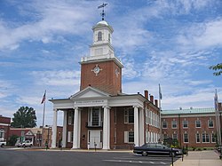
Georgetown is unusual among Delaware municipalities as the town was constructed around a circle, instead of the more traditional park square. Located at "The Circle" are the Town Hall, state and county buildings, and the historic Sussex County Courthouse. The original Courthouse was replaced by the current structure, which was built in 1837 on South Bedford Street. It was restored in 1976 and is managed by the Georgetown Historical Society. Lawyers' offices, the newer Court of Chancery and Family Court buildings, a bank, and the Brick Hotel, recently renovated into offices, also line the Circle. This layout is similar to that found in Annapolis, Maryland. The center of Georgetown's circle is a small green park with a fountain. Georgetown's oldest church, St. Paul's Episcopal Church, was constructed in 1844 and remodeled in 1881 in the early Victorian Gothic style; its congregation organized in 1794, shortly after the close of the American Revolutionary War. It is listed on the National Register of Historic Places (NRHP).

Other recognized historic properties are the Joseph T. Adams House, Brick Hotel, Peter S. Faucett House, First Broiler House, Georgetown Coal Gasification Plant, Stella Pepper Gyles House, Judge's House and Law Office, Dr. John W. Messick House and Office, Old Sussex County Courthouse, David Carlton Pepper Farm, Redden Forest Lodge, Forester's House and Stable, Richards Mansion, St. John's Methodist Church, Short Homestead, Thomas Sipple House, Sussex County Courthouse and the Circle, Gardiner Wright Mansion and McColley's Chapel, all listed on the NRHP. [9]

Geography

Georgetown is located at 38°41′24″N75°23′08″W / 38.69000°N 75.38556°W / 38.69000; -75.38556 (38.6901134, –75.3854728). [10]

According to the United States Census Bureau, the town has a total area of 4.1 square miles (11 km2), all land.

Climate

Climate data for Georgetown, Delaware (Delaware Coastal Airport), 1991–2020 normals, extremes 1945–present
MonthJanFebMarAprMayJunJulAugSepOctNovDecYear
Record high °F (°C)77
(25)
77
(25)
88
(31)
94
(34)
98
(37)
101
(38)
104
(40)
100
(38)
98
(37)
96
(36)
86
(30)
77
(25)
104
(40)
Average high °F (°C)45.2
(7.3)
47.8
(8.8)
55.2
(12.9)
66.3
(19.1)
74.5
(23.6)
83.1
(28.4)
87.7
(30.9)
85.7
(29.8)
79.5
(26.4)
69.3
(20.7)
58.7
(14.8)
49.9
(9.9)
66.9
(19.4)
Daily mean °F (°C)36.9
(2.7)
38.9
(3.8)
45.8
(7.7)
55.8
(13.2)
64.5
(18.1)
73.6
(23.1)
78.6
(25.9)
76.7
(24.8)
70.3
(21.3)
59.3
(15.2)
49.2
(9.6)
41.3
(5.2)
57.6
(14.2)
Average low °F (°C)28.6
(−1.9)
30.0
(−1.1)
36.3
(2.4)
45.3
(7.4)
54.5
(12.5)
64.0
(17.8)
69.5
(20.8)
67.7
(19.8)
61.2
(16.2)
49.4
(9.7)
39.6
(4.2)
32.7
(0.4)
48.2
(9.0)
Record low °F (°C)−13
(−25)
−8
(−22)
3
(−16)
20
(−7)
26
(−3)
35
(2)
43
(6)
42
(6)
32
(0)
21
(−6)
14
(−10)
−7
(−22)
−13
(−25)
Average precipitation inches (mm)3.01
(76)
2.58
(66)
3.86
(98)
3.29
(84)
3.63
(92)
4.07
(103)
4.14
(105)
3.99
(101)
4.54
(115)
4.11
(104)
3.19
(81)
3.47
(88)
43.88
(1,115)
Average precipitation days (≥ 0.01 in)9.410.011.311.111.813.111.211.812.011.39.110.1132.2
Source: NOAA [11] [12]

Demographics

Historical population
CensusPop.Note
1850 777
1860 553−28.8%
1870 71028.4%
1880 89526.1%
1890 1,35351.2%
1900 1,65822.5%
1910 1,609−3.0%
1920 1,7106.3%
1930 1,7633.1%
1940 1,8203.2%
1950 1,9235.7%
1960 1,765−8.2%
1970 1,8444.5%
1980 1,710−7.3%
1990 3,732118.2%
2000 4,64324.4%
2010 6,42238.3%
2020 7,13411.1%
U.S. Decennial Census [13]

As of the census [14] of 2000, there were 4,643 people, 1,489 households, and 957 families residing in the town. The population density was 1,123.9 inhabitants per square mile (433.9/km2). There were 1,591 housing units at an average density of 385.1 per square mile (148.7/km2). The racial makeup of the town was 56.19% White, 20.87% African American, 2.07% Native American, 0.26% Asian, 0.04% Pacific Islander, 18.03% from other races, and 2.54% from two or more races. Hispanic or Latino of any race were 31.73% of the population.

There were 1,489 households, out of which 32.1% had children under the age of 18 living with them, 41.0% were married couples living together, 16.5% had a female householder with no husband present, and 35.7% were non-families. 28.1% of all households were made up of individuals, and 14.0% had someone living alone who was 65 years of age or older. The average household size was 2.97 and the average family size was 3.29.

In the town, the population was spread out, with 25.4% under the age of 18, 14.3% from 18 to 24, 30.4% from 25 to 44, 16.1% from 45 to 64, and 13.8% who were 65 years of age or older. The median age was 30 years. For every 100 females, there were 107.6 males. For every 100 females age 18 and over, there were 109.5 males.

The median income for a household in the town was $31,875, and the median income for a family was $37,925. Males had a median income of $20,886 versus $19,944 for females. The per capita income for the town was $15,288. About 20.9% of families and 25.1% of the population were below the poverty line, including 34.8% of those under age 18 and 8.4% of those age 65 or over.

In 2000, 21.6% of Georgetown residents identified as being of Guatemalan heritage. This was the highest percentage of Guatemalan Americans in any place in the country.

Infrastructure

Transportation

US 113 southbound in Georgetown 2022-07-08 10 10 37 View south along U.S. Route 113 (DuPont Boulevard) at Delaware State Route 18 and Delaware State Route 404 (Seashore Highway-Bridgeville Road) in Georgetown, Sussex County, Delaware.jpg
US 113 southbound in Georgetown

The main north–south road in Georgetown is US 113, which passes through the western part of town on Dupont Boulevard and heads south to Millsboro and Pocomoke City, Maryland and north to Milford, where it connects to DE 1 that heads north to Dover and Wilmington. US 9 runs southwest–northeast through Georgetown on Market Street, heading southwest to Laurel and northeast to Lewes and the Cape May–Lewes Ferry across the Delaware Bay. DE 18 begins at US 9 at The Circle in the center of Georgetown and heads northwest on Bedford Street before heading west toward Bridgeville. DE 404 passes through Georgetown as part of a route linking the Baltimore-Washington Metropolitan Area and the Chesapeake Bay Bridge to the Delaware Beaches, entering town from the west concurrent with DE 18 to The Circle, where it joins US 9 and heads northeast along with that route toward the beaches. US 9 Truck and DE 404 Truck provide a bypass of Georgetown to the south for truck traffic. [15] Parking in portions of downtown Georgetown near the Sussex County Courthouse are regulated by two-hour parking meters on weekdays. [16]

Georgetown's historic railroad station Georgetown Station.jpg
Georgetown's historic railroad station

The Delaware Coastal Airport is located to the east of Georgetown, offering general aviation. The nearest airport with commercial air service is the Wicomico Regional Airport in Salisbury, Maryland. [15]

DART First State provides bus service to Georgetown out of the Georgetown Transit Hub along Route 206, which connects the town to the Lewes Transit Center near Lewes; Route 212, which links Georgetown to Bridgeville, Seaford, Laurel, and Delmar; Route 303, which connects the town to Dover. [17] DART First State also operates a microtransit service called DART Connect serving the Georgetown and Millsboro areas. [18]

Until the late 1940s, the Pennsylvania Railroad operated passenger trains from Harrington, Delaware through Georgetown along the train line of the former Delaware, Maryland and Virginia Railroad (DMV). Travellers from New York or Philadelphia could take trains to Wilmington, whereupon they would take a train to Harrington for the DMV line train. The route continued south to Berlin, Maryland (near Ocean City, Maryland) and to Franklin City, Virginia. [19]

Today, the Delmarva Central Railroad operates a freight rail line called the Indian River Subdivision (the former DMV line) that runs north–south through Georgetown. In Georgetown, the Delmarva Central Railroad's Lewes Industrial Track branches east from the Indian River Subdivision and heads east to Cool Spring. [20]

Utilities

Delmarva Power, a subsidiary of Exelon, provides electricity to Georgetown. [21] Chesapeake Utilities provides natural gas to the town. [22] The Town of Georgetown Water Department provides water service to the town, operating three water plants. [23] The Town of Georgetown Wastewater Department provides sewer service to the town and some surrounding areas, operating the Georgetown Wastewater Reclamation Facility. [24] Trash and recycling collection in Georgetown is provided under contract by Waste Industries. [25]

The Bruce A. Henry Solar Farm near Georgetown became operational in 2013, and expanded from 23 to 40 acres in 2020. [26] [27]

Education

Notable people

See also

Related Research Articles

<span class="mw-page-title-main">Delmarva Peninsula</span> Large peninsula on the East Coast of the US

<span class="mw-page-title-main">Kent County, Delaware</span> County in Delaware, United States

Kent County is a county located in the central part of the U.S. state of Delaware. As of the 2020 census, the population was 181,851, making it the least populous county in Delaware. The county seat is Dover, the state capital of Delaware. It is named for Kent, an English county.

<span class="mw-page-title-main">Sussex County, Delaware</span> County in Delaware, United States

Sussex County is located in the southern part of the U.S. state of Delaware, on the Delmarva Peninsula. As of the 2020 census, the population was 237,378. The county seat is Georgetown.

<span class="mw-page-title-main">Lewes, Delaware</span> City in Delaware, United States

Lewes is an incorporated city on the Delaware Bay in eastern Sussex County, Delaware, United States. According to the 2020 census, its population was 3,303. Along with neighboring Rehoboth Beach, Lewes is one of the principal cities of Delaware's rapidly growing Cape Region. The city lies within the Salisbury, Maryland–Delaware Metropolitan Statistical Area. Lewes proudly claims to be "The First Town in The First State."

<span class="mw-page-title-main">Harrington, Delaware</span> City in Delaware, United States

Harrington is a city in Kent County, Delaware, United States. It is part of the Dover metropolitan statistical area. Harrington hosts the annual Delaware State Fair each July. The population was 3,774 in 2020.

<span class="mw-page-title-main">Milford, Delaware</span> City in Delaware, United States

Milford is a city in Kent and Sussex counties in the U.S. state of Delaware. According to the 2020 census, the population of the city is 11,190 people and 4,356 households in the city.

<span class="mw-page-title-main">Blades, Delaware</span> Town in Delaware, United States

Blades is a town in Sussex County, Delaware, United States. As of the 2010 census, the town population was 1,241, a 29.8% increase over the previous decade. It is part of the Salisbury, Maryland-Delaware Metropolitan Statistical Area.

<span class="mw-page-title-main">Bridgeville, Delaware</span> Town in Delaware, United States

Bridgeville is a town in Sussex County, Delaware, United States. According to the 2010 census, the population is 2,048, an increase of 42.6% from the previous decade. It is part of the Salisbury, Maryland-Delaware Metropolitan Statistical Area.

<span class="mw-page-title-main">Delmar, Delaware</span> Town in Delaware, United States

Delmar is a town in Sussex County, Delaware, United States, on the Maryland border along the Transpeninsular Line. Its motto is "The Little Town Too Big for One State." The population was 1,597 at the 2010 census, an increase of 13.5% over the previous decade. It is part of the Salisbury, Maryland-Delaware Metropolitan Statistical Area and a suburb of Salisbury, MD. When added with Delmar, Maryland, the total population of the town was 4,600 at the 2010 Census.

<span class="mw-page-title-main">Dewey Beach, Delaware</span> Town in Delaware, United States

Dewey Beach is an incorporated coastal town in eastern Sussex County, Delaware, United States. According to the 2010 census, the population of the town is 341, an increase of 13.3% over the previous decade. It is part of the rapidly growing Cape Region and lies within the Salisbury, Maryland-Delaware Metropolitan Statistical Area. In 2011, the NRDC awarded Dewey Beach with a 5-Star rating in water quality. This award was given only to 12 other locations, one being neighboring Rehoboth Beach. Out of the 30 states with coastline, the Delaware Beaches ranked number 1 in water quality in 2011.

<span class="mw-page-title-main">Ellendale, Delaware</span> Town in Delaware, United States

Ellendale is a town in Sussex County, Delaware, United States. The population was 487 at the 2020 census, an increase of 27.8% since the 2010 census, and a 48.9% increase since the year 2000. It is part of the Salisbury, Maryland-Delaware Metropolitan Statistical Area. Ellendale is the "Gateway to Delaware's Resort Beaches" because it is the town located on U.S. Route 113, the resort area's westernmost border, and Delaware Route 16, the resort area's northernmost border with the eastern border being the Delaware Bay and Atlantic Ocean and the southern border being the state line with Maryland.

<span class="mw-page-title-main">Frankford, Delaware</span> Town in Delaware, United States

Frankford is a town in Sussex County, Delaware, United States. The population was 847 at the 2010 census, an increase of 18.6% over the previous decade. It is part of the Salisbury, Maryland-Delaware Metropolitan Statistical Area.

<span class="mw-page-title-main">Laurel, Delaware</span> Town in Delaware, United States

Laurel is a town in Sussex County, Delaware, United States. The population was 3,708 at the time of the 2010 census. Laurel is part of the Salisbury, Maryland-Delaware Metropolitan Statistical Area. It once hosted the Laurel Blue Hens of the Eastern Shore Baseball League.

<span class="mw-page-title-main">Millsboro, Delaware</span> Town in Delaware, United States

Millsboro is a town in Sussex County, Delaware, United States. Millsboro is part of the Salisbury metropolitan area.

<span class="mw-page-title-main">Milton, Delaware</span> Town in Delaware, United States

Milton is a town in Sussex County, Delaware, United States, on the Delmarva Peninsula. It is located on the Broadkill River, which empties into Delaware Bay. The population was 2,576 at the 2010 census, an increase of 55.5% over the previous decade.

<span class="mw-page-title-main">Seaford, Delaware</span> City in Delaware, United States

Seaford is a city located along the Nanticoke River in Sussex County, Delaware, United States. According to the 2010 Census Bureau figures, the population of the city is 6,928, an increase of 3.4% from the 2000 census. It is part of the Salisbury, Maryland-Delaware Metropolitan Statistical Area.

<span class="mw-page-title-main">Delaware Route 404</span> State highway in Sussex County, Delaware, United States

Delaware Route 404 (DE 404) is a major state highway in Sussex County, Delaware that spans the east-west width of the state. DE 404's western terminus is at the Maryland border northwest of Bridgeville, where the road continues into that state as Maryland Route 404 (MD 404), and its eastern terminus is at the Five Points intersection with U.S. Route 9 (US 9), DE 1, and US 9 Business in Nassau. The route passes through rural areas as well as the towns of Bridgeville and Georgetown. DE 404 runs concurrent with DE 18 from east of Bridgeville to Georgetown and with US 9 from Georgetown to Five Points. DE 404 has a business route, DE 404 Bus., that passes through Bridgeville and a truck route, DE 404 Truck, that bypasses Georgetown. DE 404, along with MD 404, serves as a major route connecting the Chesapeake Bay Bridge and the Baltimore–Washington Metropolitan Area with the Delaware Beaches.

<span class="mw-page-title-main">Delaware Route 18</span> State highway in Sussex County Delaware, United States

Delaware Route 18 (DE 18) is a state highway located in Sussex County, Delaware. It runs from Maryland Route 318 (MD 318) at the Maryland border east of Federalsburg, Maryland, east to U.S. Route 9 (US 9) in Georgetown. DE 18 runs concurrent with DE 404 from its intersection with that highway southeast of Bridgeville to the eastern terminus, where DE 404 continues eastward to Five Points on US 9. The route passes through rural areas of western Sussex County. What would become DE 18 was built as a state highway in stages during the 1920s and 1930s. By 1936, DE 18 was designated to run from the Maryland border east through Georgetown to Lewes. In 1974, the route east of Georgetown was replaced by US 9 and US 9 Business. DE 404 was designated concurrent with the eastern portion of DE 18 by 1987.

<span class="mw-page-title-main">U.S. Route 9 in Delaware</span> Highway in Delaware

U.S. Route 9 (US 9) is a United States Numbered Highway in the Northeastern U.S., running from Laurel, Delaware, north to Champlain, New York. In Delaware, the route runs a southwest–northeast path through Sussex County. Even though US 9 is signed north–south for the remainder of its route, the segment in Delaware is signed east–west. The highway runs from its western terminus at US 13 in Laurel northeast to the Cape May–Lewes Ferry terminal in Lewes, where the ferry carries the route across the Delaware Bay to North Cape May, New Jersey. US 9 passes through rural areas and serves the communities of Laurel, Georgetown, and Lewes. US 9 intersects Delaware Route 20 (DE 20) in Hardscrabble, US 113 and DE 18/DE 404 in Georgetown, DE 30 in Gravel Hill, DE 5 in Harbeson, and DE 1 at the Five Points intersection in Nassau. US 9 runs concurrent with DE 404 between Georgetown and Five Points and with DE 1 between Five Points and Carpenters Corner.

<span class="mw-page-title-main">Special routes of U.S. Route 9</span>

A total of at least three special routes of U.S. Route 9 (US 9) exist and at least seven have been deleted.

References

  1. "2020 U.S. Gazetteer Files". United States Census Bureau. Retrieved October 31, 2021.
  2. 1 2 U.S. Geological Survey Geographic Names Information System: Georgetown, Delaware
  3. "Find a County". National Association of Counties. Archived from the original on May 31, 2011. Retrieved June 7, 2011.
  4. "The Delaware Census State Data Center". Archived from the original on December 31, 2016.
  5. Eichmann, Mark (July 27, 2022). "Southern Delaware town funds museum that continues to fly a Confederate flag". WHYY.org. Archived from the original on August 5, 2022. Retrieved October 8, 2022.
  6. J. Thomas Sharff, The History of Delaware (1888)
  7. returnday.com
  8. www.newszap.com "Return Day in Georgetown" Archived 2004-11-27 at the Wayback Machine , NewsZap, 5 November 2004
  9. "National Register Information System". National Register of Historic Places . National Park Service. July 9, 2010.
  10. "US Gazetteer files: 2010, 2000, and 1990". United States Census Bureau. February 12, 2011. Retrieved April 23, 2011.
  11. "NowData - NOAA Online Weather Data". National Oceanic and Atmospheric Administration. Retrieved June 18, 2021.
  12. "Station: Georgetown Sussex CO AP, DE". U.S. Climate Normals 2020: U.S. Monthly Climate Normals (1991-2020). National Oceanic and Atmospheric Administration. Retrieved June 18, 2021.
  13. "Census of Population and Housing". Census.gov. Retrieved June 4, 2016.
  14. "U.S. Census website". United States Census Bureau . Retrieved January 31, 2008.
  15. 1 2 Delaware Department of Transportation (2008). Delaware Official Transportation Map (PDF) (Map). Dover: Delaware Department of Transportation. Retrieved May 26, 2016.
  16. "Chapter 215: Vehicles and Traffic - Article V: Parking Meters". Town of Georgetown, Delaware. Retrieved August 22, 2018.
  17. "Routes and Schedules". DART First State. Retrieved August 16, 2013.
  18. "DART Connect" (PDF). DART First State. Retrieved April 12, 2021.
  19. "Pennsylvania Railroad, Tables 78, 81: Delaware, Maryland & Virginia Branch". Official Guide of the Railways. National Railway Publication Company. 78 (12). May 1946.
  20. Delmarva Central Railroad (PDF) (Map). Carload Express. Retrieved December 16, 2018.
  21. "Service Territory". Delmarva Power. Archived from the original on May 25, 2014. Retrieved August 15, 2017.
  22. "Delmarva Service Territory". Chesapeake Utilities. Archived from the original on August 15, 2017. Retrieved August 14, 2017.
  23. "Water". Town of Georgetown, Delaware. Retrieved March 1, 2018.
  24. "Wastewater". Town of Georgetown, Delaware. Retrieved March 1, 2018.
  25. "Utilities". Town of Georgetown, Delaware. Retrieved March 1, 2018.
  26. Petree, Rob (January 22, 2020). "DEC and Constellation Complete Expansion of Sussex County Solar Farm". WGMD. Retrieved January 27, 2020.
  27. Yaffe, Edi (December 5, 2015). "A Visit to the Bruce A. Henry Solar Energy Farm". Wharton Public Policy Initiative. Retrieved January 28, 2020.
  28. "2020 CENSUS - SCHOOL DISTRICT REFERENCE MAP: Sussex County, DE" (PDF). U.S. Census Bureau . Retrieved June 15, 2021.