
Cambria County is a county located in the U.S. state of Pennsylvania. As of the 2010 census, the population was 143,679. Its county seat is Ebensburg. The county was created on March 26, 1804, from parts of Bedford, Huntingdon, and Somerset Counties and later organized in 1807. It was named for the nation of Wales, which in Latin is known as "Cambria".

Johnstown is a city in Cambria County, Pennsylvania, United States, 43 miles (69 km) west-southwest of Altoona and 67 miles (108 km) east of Pittsburgh. The population was 20,978 at the 2010 census and estimated to be 20,402 in 2013. It is the principal city of the Johnstown, Pennsylvania, Metropolitan Statistical Area, which includes Cambria County.
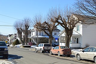
Portage is a borough with home rule status in Cambria County, Pennsylvania, United States. It is 10 miles (16 km) southeast of Ebensburg and 22 miles (35 km) southwest of Altoona. It is part of the Johnstown, Pennsylvania Metropolitan Statistical Area. The population was 2,638 at the 2010 US census.

The Johnstown Flood occurred on May 31, 1889, after the catastrophic failure of the South Fork Dam on the Little Conemaugh River 14 miles (23 km) upstream of the town of Johnstown, Pennsylvania. The dam broke after several days of extremely heavy rainfall, releasing 14.55 million cubic meters of water. With a volumetric flow rate that temporarily equaled the average flow rate of the Mississippi River, 2,209 people, according to one account, lost their lives, and the flood accounted for $17 million of damage.

The Conemaugh River is a 70-mile (110 km) long tributary of the Kiskiminetas River in Westmoreland, Indiana, and Cambria counties in the U.S. state of Pennsylvania. It crosses both the Pittsburgh metropolitan area and the Johnstown, Pennsylvania metropolitan area. The name means 'Otter Creek', originating from the Unami-Lenape language word kwənəmuxkw 'otter'.

The Allegheny Portage Railroad was the first railroad constructed through the Allegheny Mountains in central Pennsylvania, United States; it operated from 1834 to 1854 as the first transportation infrastructure through the gaps of the Allegheny that connected the midwest to the eastern seaboard across the barrier range of the Allegheny Front. Authorized as part of the Main Line of Public Works legislation in 1824, it was a series of ten inclines connecting to a branch of the Pennsylvania Canal at either end, approximately 36 miles (58 km) long overall. It had five inclines on either side of the drainage divide running athwart the ridge line from Blair Gap through along the kinked saddle at the summit into Cresson, Pennsylvania. The Portage Railroad utilized cleverly designed wheeled barges to ride a narrow-gauge rail track with steam-powered stationary engines lifting the vehicles. Except for peak moments of severe storms, it was an all-weather, all-seasons operation. Along with the rest of the Main Works, it cut transport time from Philadelphia to the Ohio River from weeks to just 3–5 days. The roadbed of the railroad did not incline monotonically upwards, but rose in relatively long, saw-toothed stretches of slightly-sloped flat terrain suitable to animal powered towing, alternating with steep cable railway inclined planes using static steam engine powered windlasses, similar to mechanisms of modern ski lifts.

The Johnstown Inclined Plane is a 896.5-foot (273.3 m) funicular in Johnstown, Cambria County in the U.S. state of Pennsylvania. The incline and its two stations connect the city of Johnstown, situated in a valley at the confluence of the Stonycreek and the Little Conemaugh Rivers, to the borough of Westmont on Yoder Hill. The Johnstown Inclined Plane is billed as the "world's steepest vehicular inclined plane", as it is capable of carrying automobiles, in addition to passengers, up or down a slope with a grade of 70.9 percent. The travel time from one station to the other is 90 seconds.

The South Fork Dam was an earthen work dam on Lake Conemaugh, an artificial body of water near South Fork, Pennsylvania, United States. On May 31, 1889, the South Fork Dam failed catastrophically and 20 million tons of water from Lake Conemaugh burst through and raced 14 miles (23 km) downstream, causing the Johnstown Flood.
Joe Magarac is a pseudo-legendary American folk hero. He is presented to readers as having been the protagonist of tales of oral folklore told by steelworkers in Pittsburgh, Pennsylvania, which later spread throughout the industrial areas of the Midwestern United States.
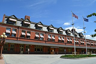
The Harrisburg Transportation Center is a large railway station and transportation hub in Harrisburg, Pennsylvania. It is located on the eastern edge of Downtown Harrisburg between the intersections of Aberdeen and Market Streets and 4th and Chestnut Streets. The well-situated station is the primary hub for passenger rail and intercity bus services in the Harrisburg metropolitan area and South Central Pennsylvania.

The Ogdensburg–Prescott International Bridge, is a suspension bridge connecting Ogdensburg, New York in the United States to Johnstown, Ontario in Canada. Designed by Modjeski & Masters and completed in 1960, it has 6 spans and a main span of 350.75 metres (1,150.8 ft) totaling 2.4 kilometres (1.5 mi) across the Saint Lawrence River and Saint Lawrence Seaway. The bridge is owned and operated by the Ogdensburg Bridge and Port Authority, which also owns and operates Ogdensburg International Airport, the Port of Ogdensburg-Marine Terminal Facility, Commerce Park, the Port of Waddington, a medium-heavy industrial park and two short line railroads. The Ogdensburg Bridge and Port Authority is a New York State public-benefit corporation.

The Roman Catholic Diocese of Altoona–Johnstown is a Roman Catholic diocese in Pennsylvania.
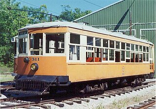
The Rockhill Trolley Museum is located at 430 Meadow Street, Rockhill Furnace, Pennsylvania, 19 miles (31 km) north of the Pennsylvania Turnpike and 11 miles (18 km) south of US 22, the William Penn Highway.

Johnstown is an Amtrak railway station in Johnstown, Pennsylvania, United States. Designed by Kenneth MacKenzie Murchison and built in 1916, the station is at 47 Walnut Street, north of downtown Johnstown across the Little Conemaugh River. Today, the station is served by Amtrak's Pennsylvanian, which operates once daily in each direction.

The Stone Bridge spans the Conemaugh River in Johnstown, Pennsylvania. The bridge is a seven-arch stone railroad bridge located on the Norfolk Southern Railway mainline, built by the Pennsylvania Railroad in 1887-88. Its upstream face was reinforced with concrete in 1929.
SaintJohnstown, Johnstoun, Johnston or Johnstone may refer to the following places:

Johnstown, is a village in County Kildare, Ireland. It is located 2 km north of Naas just off the N7 at junction 8. It is approximately 25 km from Dublin City Centre, and is a home for commuters working in Dublin and Naas. Most of the housing was built after 1990 and so it has a community website to foster local links.

The Fonda, Johnstown and Gloversville Railroad (FJ&G) was formerly a 132-mile steam engine and electric interurban railroad that connected its namesake towns in east central New York State to Schenectady, New York. It had a successful and profitable transportation business from 1870 until the 1980s carrying workers, salesmen, and executives of the very large number of glove manufacturing companies in the area to the New York Central (NYC) station at Schenectady. From here they could catch trains south to New York City (NYC) or west to Chicago. It also handled freight and had freight interchange with both the New York Central and the Delaware and Hudson railroads. Passenger business declined starting before the Great Depression and particularly during it. Following a determined and expensive effort to recapture passenger business by acquiring five ultra modern high-speed Bullet interurban cars in 1932, the FJ&G abandoned passenger service in 1938. Freight business continued on for a few more decades, was later taken over by the Delaware and Otsego Railroad management and then eventually abandoned.

St. John Gualbert Cathedral is the co-cathedral of the Roman Catholic Diocese of Altoona–Johnstown, located in Johnstown, Pennsylvania, United States. It is also a contributing property in the Downtown Johnstown Historic District on the National Register of Historic Places.
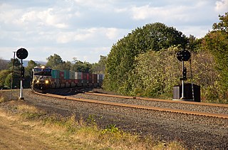
The Pittsburgh Line is a rail line that is located in state of the Pennsylvania and it is owned and operated by the Norfolk Southern Railway. The Pittsburgh Line is Norfolk Southern Railway's primary east–west artery in its Pittsburgh Division and Harrisburg Division across Pennsylvania and it is part of the Amtrak-Norfolk Southern combined rail corridor, the Keystone Corridor.


