
Dover is the capital and second-largest city of the U.S. state of Delaware. It is also the county seat of Kent County and the principal city of the Dover, DE, Metropolitan Statistical Area, which encompasses all of Kent County and is part of the Philadelphia–Wilmington–Camden, PA–NJ–DE–MD, Combined Statistical Area. It is located on the St. Jones River in the Delaware River coastal plain. It was named by William Penn for Dover in Kent, England. As of 2010, the city had a population of 36,047.

The Delmarva Peninsula, or simply Delmarva, is a large peninsula on the East Coast of the United States, occupied by the vast majority of the state of Delaware and parts of the Eastern Shore regions of Maryland and Virginia. The peninsula is 170 miles (274 km) long. In width, it ranges from 70 miles (113 km) near its center, to 12 miles (19 km) at the isthmus on its northern edge, to less near its southern tip of Cape Charles. It is bordered by the Chesapeake Bay on the west, and the Delaware River, Delaware Bay, and the Atlantic Ocean on the east.

Sussex County is located in the southern part of the U.S. state of Delaware, on the Delmarva Peninsula. As of the 2010 census, the population was 197,145. The county seat is Georgetown.

Lewes is an incorporated city on the Delaware Bay in eastern Sussex County, Delaware, United States. According to the 2010 census, the population is 2,747. Along with neighboring Rehoboth Beach, Lewes is one of the principal cities of Delaware's rapidly growing Cape Region. The city lies within the Salisbury, Maryland–Delaware Metropolitan Statistical Area. Lewes proudly claims to be "The First Town in The First State."

Ellendale is a town in Sussex County, Delaware, United States. The population was 381 at the 2010 census, an increase of 16.5% since 2000. It is part of the Salisbury, Maryland-Delaware Metropolitan Statistical Area. Ellendale is the "Gateway to Delaware's Resort Beaches" because it is the town located on U.S. Highway 113, the resort area's westernmost border, and Delaware Route 16, the resort area's northernmost border with the eastern border being the Delaware Bay and Atlantic Ocean and the southern border being the state line with Maryland.
Georgetown is a town in and the county seat of Sussex County, Delaware, United States. According to the 2010 census, the population of the town is 6,422, an increase of 38.3% over the previous decade.
U.S. Route 113 (US 113) is a spur of US 13 in the U.S. states of Maryland and Delaware. The U.S. Highway runs 74.75 miles (120.30 km) from US 13 in Pocomoke City, Maryland north to Delaware Route 1 (DE 1) in Milford, Delaware. In conjunction with DE 1, US 113 is one of two major north–south highways on the Delmarva Peninsula that connect Dover with Pocomoke City and the Eastern Shore of Virginia. The U.S. Highway is the primary north–south highway in Worcester County, Maryland, where it connects Pocomoke City with Snow Hill and Berlin. US 113 is one of three major north–south highways in Sussex County, Delaware, where it connects Selbyville, Millsboro, and Georgetown with Milford. While US 113 does not pass through Ocean City or the Delaware Beaches, the U.S. Highway intersects several highways that serve the Atlantic seaboard resorts, including US 50, Maryland Route 90 (MD 90), US 9, DE 404, and DE 1. US 113 is a four-lane divided highway for its whole length.

The Eastern Shore of Maryland is a part of the U.S. state of Maryland that lies mostly on the east side of the Chesapeake Bay and consists of nine counties, seven of which have Chesapeake Bay coastlines. The region also contains Maryland's only coast along the Atlantic Ocean.

The Capital Subdivision is a railroad line owned and operated by CSX Transportation in the U.S. state of Maryland and the District of Columbia. The line runs from near Baltimore, Maryland, southwest to Washington, D.C., along the former Baltimore and Ohio Rail Road (B&O) Washington Branch. The subdivision's Alexandria Extension provides a connection to Virginia and points south.
The Baltimore and Delaware Bay Railroad, originally part of the Central Railroad of New Jersey's route from New York City to Baltimore, Maryland via central Delaware, was later part of the Pennsylvania Railroad system.

The Maryland and Delaware Railroad Company is a Class III short-line railroad, formed in 1977 to operate several branch lines of the former Penn Central Railroad in both Maryland and Delaware, United States. These branches were omitted from the system plan for Conrail in 1976 and would have been discontinued without state subsidies. As an alternative to the higher cost of subsidizing Conrail as operator of the branch lines, the Maryland and Delaware governments selected the Maryland and Delaware Railroad Company (MDDE) to serve as the designated operator.

Maryland Route 300 is a state highway in the U.S. state of Maryland. Known for most of its length as Sudlersville Road, the highway runs 13.55 miles (21.81 km) from MD 213 in Church Hill east through Sudlersville to the Delaware state line, where the highway continues as Delaware Route 300. MD 300 forms part of an east–west connection between U.S. Route 301 in northern Queen Anne's County and Dover, Delaware. MD 300 between Church Hill and Dudley Corners was one of the original state roads marked for improvement in 1909, but the county constructed the highway with state aid in the mid- to late-1910s from Church Hill to Sudlersville. The highway from Sudlersville to the state line was built in the late 1920s and early 1930s. MD 300 was widened over its entire length around 1950 and extended west to US 213's bypass of Church Hill around 1970. MD 300 was officially split in two when its superstreet intersection with US 301 was built in 2005.
U.S. Route 1 is a major north–south U.S. Highway, extending from Key West, Florida in the Florida Keys in the south to Fort Kent, Maine at the Canadian border in the north. In the U.S. state of Pennsylvania, US 1 runs for 81 miles (130 km) from the Maryland state line near Nottingham to the New Jersey state line at the Delaware River in Morrisville, through the southeastern portion of the state. The route runs southwest to northeast, and serves as a major arterial road through the city of Philadelphia and for many of the suburbs in the Delaware Valley area. South of Philadelphia, the road mostly follows the alignment of the old Baltimore Pike. Within Philadelphia, it mostly follows Roosevelt Boulevard.

The Queen Anne’s Railroad was a railroad that ran between Love Point, Maryland and Lewes, Delaware and was connected to Baltimore via ferry across the Chesapeake Bay. The Queen Anne's Railroad company was formed in Maryland in 1894, and received legislative authorization from Delaware in February 1895. The railroad's original western terminus was in Queenstown, Maryland, and was moved via a 13-mile (21 km) extension to Love Point in 1902, which shortened the ferry trip to Baltimore.
U.S. Route 9 (US 9) is a U.S. highway in the northeast United States, running from Laurel, Delaware north to Champlain, New York. In Delaware, the route runs an east–west path through Sussex County. Even though US 9 is signed north–south for the remainder of its route, the segment in Delaware is signed east–west. The highway runs from its western terminus at US 13 in Laurel east to the Cape May–Lewes Ferry terminal in Lewes, where the ferry carries the route across the Delaware Bay to North Cape May, New Jersey. US 9 passes through rural areas and serves the communities of Laurel, Georgetown and Lewes. US 9 intersects Delaware Route 20 (DE 20) in Hardscrabble, US 113 and DE 18/DE 404 in Georgetown, DE 30 in Gravel Hill, DE 5 in Harbeson, and DE 1 at the Five Points intersection in Nassau. Between Georgetown and Five Points, US 9 runs concurrent with DE 404.

Maryland Route 405 is a state highway in the U.S. state of Maryland. Known as Price Station Road, the highway runs 8.59 miles (13.82 km) from MD 19 near Church Hill east to MD 304 near Bridgetown. MD 405 connects Church Hill and Bridgetown with the central Queen Anne's County community of Price, where the highway intersects U.S. Route 301. The highway was constructed from Price to south of Roe in the early 1930s and from Price to Church Hill in the mid-1930s. MD 405 was extended from Roe to the Caroline County line west of Bridgetown in the early 1940s. The highway was extended to Bridgetown in the late 1950s and truncated at its present eastern terminus when MD 304 was extended east to Bridgetown in the late 1960s.
The Delaware Coast Line Railroad was a short-line railroad located in Sussex County, Delaware. The company operated two lines on track owned by the State of Delaware: one running from Ellendale east to Milton and another running from Georgetown east to Cool Spring. The railroad interchanged with the Delmarva Central Railroad in Ellendale and Georgetown. It was owned by Dan Herholdt. Part of the rail lines were taken over by the Delmarva Central railroad.
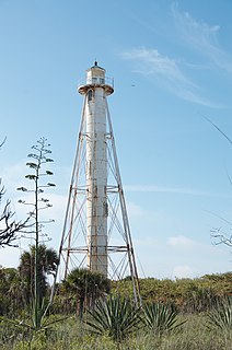
The Delaware Breakwater Range Rear Light was a lighthouse west of Lewes, Delaware. It was made obsolete by the shifting of Cape Henlopen and was disassembled and moved to Florida to become the Boca Grande Entrance Range Rear Light.
The Del-Mar-Va Express was a named passenger train of the Pennsylvania Railroad that at its peak went from New York City to the southernmost point of the Delmarva Peninsula, Cape Charles, Virginia. Initiated in 1926, the train's north–south passage through Delaware stood in contrast with the main passenger traffic through Delaware being a brief passage through cities in the upper reach of Delaware, mainly Wilmington. Most importantly, the train served as a more direct path from New York City and Philadelphia to Norfolk, Virginia, by way of a ferry from Cape Charles across the Chesapeake Bay to Norfolk, a path that bypassed Baltimore and Washington, D.C. This saved time in comparison to travel over PRR, Atlantic Coast Line and Norfolk & Western trains through Washington to Norfolk. The Del-Mar-Va trip, including ferry travel was 11 hours from New York; and the longer all-land route through Washington was 13 hours and 40 minutes.


