
The Delmarva Peninsula, or simply Delmarva, is a large peninsula on the East Coast of the United States, occupied by the vast majority of the state of Delaware and parts of the Eastern Shore regions of Maryland and Virginia. The peninsula is 170 miles (274 km) long. In width, it ranges from 70 miles (113 km) near its center, to 12 miles (19 km) at the isthmus on its northern edge, to less near its southern tip of Cape Charles. It is bordered by the Chesapeake Bay on the west, Pocomoke Sound on the northwest, the Delaware River, Delaware Bay, and the Atlantic Ocean on the east.

Sussex County is located in the southern part of the U.S. state of Delaware, on the Delmarva Peninsula. As of the 2010 census, the population was 197,145. The county seat is Georgetown.

Thomas Bayard McCabe was president and chief executive officer of Scott Paper Company for 39 years. McCabe also held several important government offices during the administrations of Franklin D. Roosevelt and Harry S. Truman. Most notably, he was appointed by President Truman to serve as Chairman of the Board of Governors of the Federal Reserve in the years following World War II.

Buildings, sites, districts, and objects in Delaware listed on the National Register of Historic Places:
The following properties are listed on the National Register of Historic Places in Sussex County, Delaware, United States.
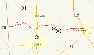
Delaware Route 18 (DE 18) is a state highway located in Sussex County, Delaware. It runs from Maryland Route 318 (MD 318) at the Maryland border east of Federalsburg, Maryland to U.S. Route 9 (US 9) in Georgetown. DE 18 runs concurrent with DE 404 from its intersection with that highway southeast of Bridgeville to the eastern terminus, where DE 404 continues eastward to Five Points on US 9. The route passes through rural areas of western Sussex County. What would become DE 18 was built as a state highway in stages during the 1920s and 1930s. By 1936, DE 18 was designated to run from the Maryland border east through Georgetown to Lewes. In 1974, the route east of Georgetown was replaced by US 9 and US 9 Business. DE 404 was designated along the eastern portion of DE 18 by 1987.

Cedar Creek is a collection of developments and residences mainly surrounding Swiggetts Pond and Cubbage Pond along the Cedar Creek in Sussex County, Delaware, United States. It is part of the Salisbury, Maryland-Delaware Metropolitan Statistical Area. The area generally referred to as Cedar Creek follows Fleatown Road from Clendaniel Pond Road to Delaware Route 1, then heads south to Slaughter Neck Road, following Slaughter Neck Road until it connects with Cubbage Pond Road, ending back at the intersection of Cubbage Pond Road and Fleatown Road. The developments include Cedar Creek Estates, Cedar Village, The Meadows on Cubbage Pond, South Shores, The Village at Anderson Crossroads, and Pine Haven Park. Cedar Creek Nature Preserve is also located here off of Brick Granary Road where the Cedar Creek flows into Swiggetts Pond.
U.S. Route 9 (US 9) is a U.S. highway in the northeast United States, running from Laurel, Delaware north to Champlain, New York. In Delaware, the route runs an east–west path through Sussex County. Even though US 9 is signed north–south for the remainder of its route, the segment in Delaware is signed east–west. The highway runs from its western terminus at US 13 in Laurel east to the Cape May–Lewes Ferry terminal in Lewes, where the ferry carries the route across the Delaware Bay to North Cape May, New Jersey. US 9 passes through rural areas and serves the communities of Laurel, Georgetown and Lewes. US 9 intersects Delaware Route 20 (DE 20) in Hardscrabble, US 113 and DE 18/DE 404 in Georgetown, DE 30 in Gravel Hill, DE 5 in Harbeson, and DE 1 at the Five Points intersection in Nassau. Between Georgetown and Five Points, US 9 runs concurrent with DE 404.

Omar is an unincorporated community in Sussex County, Delaware, United States, located at the crossroads of Delaware Route 20 and Sussex County Road 54 and between the towns of Dagsboro and Roxana.
Whaleys Corners is an unincorporated community in Sussex County, Delaware, United States. Whaleys Corners is located on U.S. Route 9 southwest of Georgetown.
McDonalds Crossroads is a locality in Sussex County, Delaware, United States. McDonalds Crossroads is 3.5 miles (5.6 km) southwest of Georgetown.

Springfield Crossroads is a locality in Sussex County, Delaware, United States. Springfield Crossroads is located on Delaware Route 30 north of Millsboro. It is 4.3 miles (6.9 km) southwest of Georgetown.
Hearns Crossroads is a place in Sussex County, Delaware, United States. Hearns Crossroads is southeast of Laurel.

Reliance is an unincorporated community located on the border of the U.S. states of Maryland and Delaware. The Maryland side of the community has portions in Caroline and Dorchester counties, while the Delaware side is located within Sussex County. Reliance is along Delaware Route 20 and Maryland Route 392 at the junction with Maryland Route 577, west of Seaford. It was previously known as Johnson's Crossroads.
Adams Crossroads is an settlement 2.7 miles (4.3 km) southeast of Hickman in Sussex County, Delaware, United States. Adams Crossroads is located at the intersection of Delaware Route 404 and Adamsville Road northwest of Bridgeville in the Northwest Fork Hundred.
Milford Crossroads is an unincorporated community in New Castle County, Delaware, United States. Milford Crossroads is located along Delaware Route 72 at the intersection of Possum Park Road/Thompson Station Road and Paper Mill Road northeast of Newark.
Adams Crossroads may refer to:

Asketum Branch is a 2.23 mi (3.59 km) long 1st order tributary to Tyndall Branch, in Sussex County, Delaware.
Stoney Branch is a 4.30 mi (6.92 km) long 3rd order tributary to Tyndall Branch, in Sussex County, Delaware.


