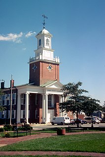
Sussex County is a county located in the southern part of the U.S. state of Delaware, on the Delmarva Peninsula. As of the 2010 census, the population was 197,145. The county seat is Georgetown.

Bethany Beach is an incorporated town in Sussex County, Delaware, United States. According to the 2010 Census Bureau figures, the population of the town is 1,060; however, during the summer months some 15,000 more populate the town as vacationers. It is part of the Salisbury, MD-DE Metropolitan Statistical Area.

Fenwick Island is a coastal town in Sussex County, Delaware, USA. According to 2010 census figures, the population of the town is 379, a 10.8% increase over the last decade. It is part of the Salisbury, Maryland-Delaware Metropolitan Statistical Area. The town is located on Fenwick Island, a barrier spit.
Henlopen Acres is a municipality north of Rehoboth Beach in Sussex County, Delaware, United States, and is the third smallest incorporated town in Delaware. According to 2010 census figures, the population of the town is 122, a decrease of 12.2% from the 2000 census. It is part of the Salisbury, Maryland-Delaware Metropolitan Statistical Area.

Millville is a town in Sussex County, Delaware, United States. The population was 544 at the 2010 census, an increase of 110% from the previous decade. It is part of the Salisbury, Maryland-Delaware Metropolitan Statistical Area and lies within Baltimore Hundred.

Rehoboth Beach is a city on the Atlantic Ocean along the Delaware Beaches in eastern Sussex County, Delaware, United States. As of the 2010 United States Census, the population was 1,327, reflecting a decline of 161 (11.2%) from the 1,488 counted in the 2000 Census. Along with the neighboring coastal city of Lewes, Rehoboth Beach is one of the principal cities of Delaware's rapidly growing Cape Region. Rehoboth Beach lies within the Salisbury, Maryland-Delaware Metropolitan Statistical Area.

South Bethany is an incorporated town in Sussex County, Delaware, United States. According to the 2010 census, the population of the town is 449, a decrease of 8.7% over the previous decade. It is part of the Salisbury, Maryland-Delaware Metropolitan Statistical Area.
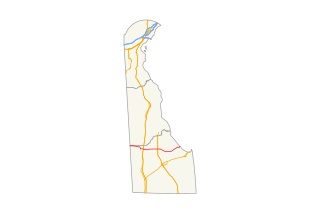
U.S. Route 113 (US 113) is a spur of US 13 in the U.S. states of Maryland and Delaware. The U.S. Highway runs 74.75 miles (120.30 km) from US 13 in Pocomoke City, Maryland north to Delaware Route 1 (DE 1) in Milford, Delaware. In conjunction with DE 1, US 113 is one of two major north–south highways on the Delmarva Peninsula that connect Dover with Pocomoke City and the Eastern Shore of Virginia. The U.S. Highway is the primary north–south highway in Worcester County, Maryland, where it connects Pocomoke City with Snow Hill and Berlin. US 113 is one of three major north–south highways in Sussex County, Delaware, where it connects Selbyville and Georgetown with Milford. While US 113 does not pass through Ocean City or the Delaware Beaches, the U.S. Highway intersects several highways that serve the Atlantic seaboard resorts, including US 50, Maryland Route 90 (MD 90), US 9, and DE 1. US 113 is a four-lane divided highway for its whole length except for between Snow Hill and Berlin, where it is a two-lane undivided road.
Delaware Route 1 (DE 1) is a 103.02-mile-long (165.79 km) state highway in the U.S. state of Delaware. The route runs from the Maryland border in Fenwick Island, Sussex County, where it continues south into that state as Maryland Route 528 (MD 528), north to an interchange with DE 58 in Christiana, New Castle County, where the road continues north as DE 7. Between Fenwick Island and Dover Air Force Base in Dover, Kent County, DE 1 is a four- to six-lane surface divided highway with occasional interchanges. The route heads north past the Delaware Beaches along the Atlantic Ocean before it runs northwest through rural areas, turning north at Milford to continue to Dover. Upon reaching Dover, DE 1 becomes the Korean War Veterans Memorial Highway, a four- to six-lane freeway that is tolled. Between Dover and Tybouts Corner, DE 1 parallels U.S. Route 13 (US 13), crossing over and featuring interchanges with it multiple times. Past Tybouts Corner, the freeway heads north to Christiana, reaching an interchange with Interstate 95 (I-95) a short distance before its terminus. DE 1 serves as the main north-south state route in Delaware, connecting the Delaware Beaches with the Dover and Wilmington areas.
Delaware Route 16 (DE 16) is an east-west state highway in Delaware, mainly across northern Sussex County, with a small portion near the Maryland border in extreme southwestern Kent County. It runs from Maryland Route 16 (MD 16) at the Maryland border in Hickman to the Delaware Bay at Broadkill Beach. The route runs through rural areas, passing through the towns of Greenwood, Ellendale, and Milton. DE 16 intersects U.S. Route 13 (US 13) and DE 36 in Greenwood, US 113 in Ellendale, DE 30 and DE 5 in the Milton area, and DE 1 between Milton and Broadkill Beach. West of DE 1, the route serves as part of a connection between the Baltimore-Washington Metropolitan Area and the Delaware Beaches. DE 16 was built as a state highway during the 1920s and 1930s. By 1936, the route was designated onto its current alignment.
Maryland Route 54 (MD 54) and Delaware Route 54 (DE 54) are adjoining state highways in the U.S. states of Maryland and Delaware. Route 54 runs 41.84 mi (67.33 km) from MD 313 in Mardela Springs, Maryland east to DE 1 in Fenwick Island, Delaware. In addition to two segments in which the highway is completely in Delaware and two segments in which the highway is completely in Maryland, Route 54 follows the Delaware/Maryland state line between the twin towns of Delmar, Maryland and Delmar, Delaware and the highway's intersection with MD 353 and DE 26. One section of the state line portion of Route 54 is maintained by the Delaware Department of Transportation (DelDOT) while three sections of the highway that follow the state line are maintained by the Maryland State Highway Administration (MDSHA).

Delaware Route 14 (DE 14) is a state highway in the southern part of Kent County, Delaware. The route runs from the Maryland border near Burrsville, Maryland, where it continues as Maryland Route 317 (MD 317), east to DE 1 in Milford. The route passes through Harrington, where it intersects U.S. Route 13 (US 13), and passes to the north of Houston before coming to Milford, where it intersects DE 15, US 113, and DE 1 Business. DE 14 has a truck bypass of Harrington known as DE 14 Truck.

Delaware Route 26 (DE 26) is a state highway in Sussex County, Delaware. The route's western terminus is at an intersection with Maryland Route 353 (MD 353) and DE/MD 54 at the Maryland border south of Gumboro and its eastern terminus is at a dead end on the Atlantic Ocean in Bethany Beach, even though signage ends at the DE 1 intersection. The route passes through rural areas of southeastern Sussex County along with the communities of Dagsboro, Millville, Ocean View and Bethany Beach. DE 26 intersects DE 30 and DE 54 in the Gumboro area, U.S. Route 113 (US 113) and DE 20 in Dagsboro, and DE 17 west of Millville. The road was built as a state highway in various stages during the 1920s and 1930s. By 1936, DE 26 was assigned onto its current alignment.

Delaware Route 17 (DE 17) is a two-lane undivided state highway located in Sussex County, Delaware. The route runs in a northeast-southwest direction between DE 54 in Selbyville and DE 26 west of Millville, crossing DE 20 in Roxana. It is called Bethany Road within Selbyville and Roxana Road for the remainder of its length. The route passes through rural areas of southeastern Sussex County. DE 17 serves to connect Selbyville with the Bethany Beach area. The route was built as a state highway in the 1920s and received the DE 17 designation by 1938.
The Salisbury, MD-DE Metropolitan Statistical Area, as defined by the United States Census Bureau is a metropolitan area centered on the city of Salisbury, Maryland and consists of four counties: Somerset, Wicomico, and Worcester in Maryland and Sussex in Delaware. The MSA had a total population of 373,802 as of the 2010 census and an estimated population of 405,803 for 2017.
The Indian River School District is a public school district in Sussex County, Delaware in the United States. The district is based in Selbyville and serves the southeastern portion of Sussex County.

Middlesex Beach is an unincorporated community in Sussex County, Delaware, United States. Middlesex Beach is located on the Atlantic Ocean and Delaware Route 1 between Bethany Beach and South Bethany. The community was built in 1958-1959.
York Beach is an unincorporated community in Sussex County, Delaware, United States. York Beach is located on the Atlantic Ocean and Delaware Route 1 south of South Bethany.
North Shores is an unincorporated community in Sussex County, Delaware, United States. North Shores is located along the Atlantic Ocean north of Henlopen Acres and Rehoboth Beach and south of Cape Henlopen State Park.


