
New Sweden was a Swedish colony along the lower reaches of the Delaware River in America from 1638 to 1655, established during the Thirty Years' War when Sweden was a great military power. New Sweden formed part of the Swedish efforts to colonize the Americas. Settlements were established on both sides of the Delaware Valley in the region of Delaware, New Jersey, Maryland, and Pennsylvania, often in places where Swedish traders had been visiting since about 1610. Fort Christina in Wilmington, Delaware was the first settlement, named after the reigning Swedish monarch. The settlers were Swedes, Finns, and a number of Dutch. New Sweden was conquered by the Dutch Republic in 1655 during the Second Northern War and incorporated into the Dutch colony of New Netherland.
Delaware County is a county located in the US state of New York. As of 2010 the population was 47,980. The county seat is Delhi. The county is named after the Delaware River, which was named in honor of Thomas West, 3rd Baron De La Warr, appointed governor of Virginia in 1609.

Dover is the capital and second-largest city of the U.S. state of Delaware. It is also the county seat of Kent County and the principal city of the Dover, DE, Metropolitan Statistical Area, which encompasses all of Kent County and is part of the Philadelphia–Wilmington–Camden, PA–NJ–DE–MD, Combined Statistical Area. It is located on the St. Jones River in the Delaware River coastal plain. It was named by William Penn for Dover in Kent, England. As of 2010, the city had a population of 36,047.

Delaware City is a city in New Castle County, Delaware, United States. The population was 1,695 at the 2010 census. It is a small port town on the eastern terminus of the Chesapeake and Delaware Canal and is the location of the Forts Ferry Crossing to Fort Delaware on Pea Patch Island.

New Castle is a city in New Castle County, Delaware, United States, six miles (10 km) south of Wilmington, and situated on the Delaware River. According to the 2010 Census, the population of the city is 5,285.

Newark is a city in New Castle County, Delaware, United States. It is located 12 miles (19 km) west-southwest of Wilmington. According to the 2010 Census, the population of the city is 31,454. Newark is home to the University of Delaware.
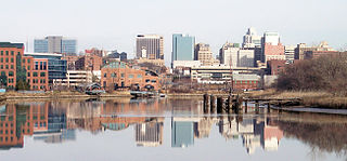
Wilmington is the largest and most populous city in the U.S. state of Delaware. The city was built on the site of Fort Christina, the first Swedish settlement in North America. It lies at the confluence of the Christina River and Brandywine River, near where the Christina flows into the Delaware River. It is the county seat of New Castle County and one of the major cities in the Delaware Valley metropolitan area. Wilmington was named by Proprietor Thomas Penn after his friend Spencer Compton, Earl of Wilmington, who was prime minister during the reign of George II of Great Britain.

The Delaware and Raritan Canal is a canal in central New Jersey, United States, built in the 1830s, that served to connect the Delaware River to the Raritan River. It was an efficient and reliable means of transportation of freight between Philadelphia and New York City, especially coal from the anthracite fields in eastern Pennsylvania, during much of the 19th and early 20th centuries. The canal allowed shippers to cut many miles off the existing route from the Pennsylvania coal fields, down the Delaware, around Cape May, and up along the Atlantic Ocean coast to New York City.
U.S. Route 46 (US 46) is an east–west U.S. Highway completely within the state of New Jersey, running for 75.34 mi (121.25 km), making it the shortest signed, non-spur U.S. Highway. The west end is at an interchange with Interstate 80 (I-80) and Route 94 in Columbia, Warren County on the Delaware River. The east end is in the middle of the George Washington Bridge over the Hudson River in Fort Lee, Bergen County while the route is concurrent with I-95 and US 1-9. Throughout much of its length, US 46 is closely paralleled by I-80. US 46 is a major local and suburban route, with some sections built to or near freeway standards and many other sections arterials with jughandles. The route runs through several communities in the northern part of New Jersey, including Hackettstown, Netcong, Dover, Parsippany-Troy Hills, Wayne, Clifton, Ridgefield Park, Palisades Park, and Fort Lee. It crosses over the Upper Passaic River at several points. The road has been ceremonially named the United Spanish–American War Veterans Memorial Highway.
The Darlington's Bridge at Delaware Station was a highway bridge over the Delaware River in the community of Delaware, New Jersey. Formerly a railroad bridge constructed by the Delaware, Lackawanna and Western Railroad in 1871 to replace an earlier 1855 timber span, the bridge was sold off when the new one upstream was constructed. Henry V. Darlington, an Episcopal minister in Delaware and nearby Belvidere offered to buy the second-hand bridge for $5,000. Darlington converted it into a highway bridge, using two fired members of the nearby Meyer's Ferry to be toll collectors. The bridge prospered, becoming a part of State Highway Route 6 in 1927 and U.S. Route 46 in 1936. In 1932, during the massive state takeover of bridges by the Delaware River Joint Toll Bridge Commission, Darlington refused offers, bargaining his way up to $275,000 before accepting the sale. This amount was a far cry from the nearby Belvidere-Riverton and Portland-Columbia Covered Bridge, which were accepted for $60,000 and $50,000 respectively. On that moment, tolls along the bridge and Route 6 were eliminated. The bridge prospered toll-free for another 21 years, until the construction of the Portland-Columbia Toll Bridge upstream at Columbia. Darlington was still alive to see all this transpire. The Commission ceased operations on the Darlington Bridge on April 3, 1954, and the bridge was immediately demolished.

The Delaware Valley is the valley through which the Delaware River flows. By extension, this toponym is commonly used to refer to Greater Philadelphia or the Philadelphia metropolitan area. The Delaware Valley is coterminous with a metropolitan statistical area (MSA) and broader combined statistical area (CSA), and is composed of counties located in Southeastern Pennsylvania, South Jersey, Delaware, and the Eastern Shore of Maryland. As of the 2010 Census, the MSA has a population of over 6 million, while the CSA has a population of over 7.1 million.
Interstate 295 (I-295) in Delaware, New Jersey, and Pennsylvania is an auxiliary Interstate Highway, designated as a bypass around Philadelphia and a partial beltway of Trenton, New Jersey. The route begins at a junction with I-95 south of Wilmington, Delaware, and runs to an interchange with I-95 in Bristol Township, Pennsylvania. The highway heads east from I-95 and crosses the Delaware River into New Jersey on the Delaware Memorial Bridge concurrent with U.S. Route 40 (US 40). Upon entering New Jersey, I-295 splits from the New Jersey Turnpike and US 40, and runs parallel to the turnpike for most of its course in the state. After a concurrency with US 130 in Gloucester County, I-295 has an interchange with I-76 and Route 42 in Camden County. The freeway continues northeast toward Trenton, where it intersects I-195 and Route 29 before bypassing the city to the east, north, and west, crossing the Delaware River on the Scudder Falls Bridge into Pennsylvania. In Pennsylvania, I-295 is signed as an east–west road and heads south to its other terminus at I-95. I-295 is one of two three-digit interstates in the United States to enter three states, with the other one being the I-275 beltway around Cincinnati which enters Ohio, Indiana, and Kentucky.
Delaware Route 1 (DE 1) is a 103.02-mile-long (165.79 km) state highway in the U.S. state of Delaware. The route runs from the Maryland state line in Fenwick Island, Sussex County, where the road continues south into that state as Maryland Route 528 (MD 528), north to an interchange with DE 58 in Christiana, New Castle County, where the road continues north as part of DE 7. Between Fenwick Island and Dover Air Force Base in Dover, Kent County, DE 1 is a four- to six-lane divided highway with at-grade intersections and occasional interchanges. The route heads north through the Delaware Beaches resort area along the Atlantic Ocean before it runs northwest through rural areas, turning north at Milford to continue to Dover. Upon reaching Dover, DE 1 becomes the Korean War Veterans Memorial Highway, a four- to six-lane freeway that is tolled. Between Dover and Tybouts Corner, DE 1 parallels U.S. Route 13 (US 13), crossing over and featuring interchanges with it multiple times. Past Tybouts Corner, the freeway heads north to Christiana, reaching an interchange with Interstate 95 (I-95) a short distance before its terminus. DE 1 serves as the main north-south state route in Delaware, connecting the Delaware Beaches with the Dover and Wilmington areas.
Brandywine Hundred is an unincorporated subdivision of New Castle County, Delaware, United States. It is located to the north and northeast of the city of Wilmington. Hundreds were once used as a basis for representation in the Delaware General Assembly. Brandywine Hundred and North Wilmington are commonly used colloquial names for this area. However, while their names still appear on all real estate transactions, all other hundreds in Delaware presently have no meaningful use or purpose except as a geographical point of reference. In the 2010 census, Brandywine had 77,182 people.

Gloria Dei Church, known locally as Old Swedes', is a historic church located in the Southwark neighborhood of Philadelphia, Pennsylvania, at 929 South Water Street, bounded by Christian Street on the north, South Christopher Columbus Boulevard on the east, and Washington Avenue on the south. It was built between 1698 and 1700, making it the oldest church in Pennsylvania and second oldest Swedish church in the United States after Holy Trinity Church in Wilmington, Delaware.

Holy Trinity Church, also known as Old Swedes, is a historic church at East 7th and Church Street in Wilmington, Delaware. It was consecrated on Trinity Sunday, June 4, 1699, by a predominantly Swedish congregation formerly of the colony of New Sweden. The church, designated a National Historic Landmark in 1961, is among the few surviving public buildings that reflect the Swedish colonial effort. The church is considered part of First State National Historical Park. The church, which is often visited by tourists, remains open today for tours and religious activities.

Fort Casimir or Fort Trinity was a Dutch fort in the seventeenth-century colony of New Netherland. It was located on a no-longer existing barrier island at the end of Chestnut Street in what is now New Castle, Delaware.

The Queen Anne’s Railroad was a railroad that ran between Love Point, Maryland and Lewes, Delaware and was connected to Baltimore via ferry across the Chesapeake Bay. The Queen Anne's Railroad company was formed in Maryland in 1894, and received legislative authorization from Delaware in February 1895. The railroad's original western terminus was in Queenstown, Maryland, and was moved via a 13-mile (21 km) extension to Love Point in 1902, which shortened the ferry trip to Baltimore.

The Delaware State Route System consists of roads in the U.S. state of Delaware that are maintained by the Delaware Department of Transportation (DelDOT). The system includes the portions of the Interstate Highway System and United States Numbered Highways system located in the state along with state routes and other roads maintained by DelDOT. All roads maintained by the state are assigned a maintenance road number that is only marked on little white markers at intersections and on auxiliary plates below warning signs approaching intersections. These numbers are only unique in a specific county; some roads can be designated with multiple road numbers, and numbers do not necessarily correspond to the signed Interstate, U.S., or state route numbers. DelDOT maintains a total of 5,386.14 miles (8,668.15 km) of roads, comprising 89 percent of the roads within the state. Some large bridges in the state are maintained by other agencies including the U.S. Army Corps of Engineers and the Delaware River and Bay Authority. Roads in the system include multilane freeways, multilane surface divided highways, and two-lane undivided roads serving urban, suburban, and rural areas. Some of the roads maintained by DelDOT are toll roads, in which motorists must pay to use.


