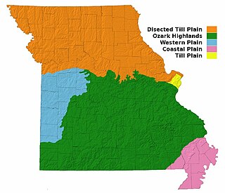
Missouri, a state near the geographical center of the United States, has three distinct physiographic divisions:

The Ozarks, also known as the Ozark Mountains or Ozark Plateau, is a physiographic region in the U.S. states of Missouri, Arkansas, Oklahoma and the extreme southeastern corner of Kansas. The Ozarks cover a significant portion of northern Arkansas and most of the southern half of Missouri, extending from Interstate 40 in central Arkansas to Interstate 70 in central Missouri.

Southern Illinois, also known as Little Egypt, is the southern third of Illinois, principally along and south of Interstate 64. Although part of a Midwestern state, this region is aligned in culture more with that of the Upland South than the Midwest. Part of downstate Illinois, it is bordered by the two most voluminous rivers in the United States: the Mississippi below its connecting Missouri River to the west and the Ohio River to the east and south with the Wabash as tributary.

The Tradewater River is a tributary of the Ohio River, approximately 136 miles (219 km) long, in western Kentucky in the United States. It drains an area of 932 square miles (2,410 km2) in the limestone hills south of Evansville, Indiana, between the basins of the Cumberland River on the west and the Green River on the east.

The Gulf Coastal Plain extends around the Gulf of Mexico in the Southern United States and eastern Mexico.
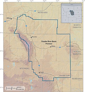
The Powder River Basin is a geologic structural basin in southeast Montana and northeast Wyoming, about 120 miles (190 km) east to west and 200 miles (320 km) north to south, known for its extensive coal reserves. The former hunting grounds of the Oglala Lakota, the area is very sparsely populated and is known for its rolling grasslands and semiarid climate.
The Driftless Area, a topographical and cultural region in the American Midwest, comprises southwestern Wisconsin, southeastern Minnesota, northeastern Iowa, and the extreme northwestern corner of Illinois.

The Shawnee National Forest is a United States National Forest located in the Ozark and Shawnee Hills of Southern Illinois, United States. Administered by the U.S.D.A. Forest Service, it consists of approximately 280,000 acres (1,100 km²) of federally managed lands. In descending order of land area it is located in parts of Pope, Jackson, Union, Hardin, Alexander, Saline, Gallatin, Johnson, and Massac counties. Forest headquarters are located in Harrisburg, Illinois. There are local ranger district offices in Jonesboro and Vienna. The Shawnee National Forest is also the single largest publicly owned body of land in the state of Illinois. It is considered part of Southern Illinois, and is south of the St. Louis, Missouri, and Metro East areas, in area code 618. Portions of it are in the far south area of Illinois known as Little Egypt. Cities in or near the area are Carbondale, Illinois, Marion, Illinois, and Cairo, Illinois.
Illinois is in the midwestern United States. Surrounding states are Wisconsin to the north, Iowa and Missouri to the west, Kentucky to the east and south, and Indiana to the east. Illinois also borders Michigan, but only via a northeastern water boundary in Lake Michigan. Nearly the entire western boundary of Illinois is the Mississippi River, except for a few areas where the river has changed course. Illinois' southeastern and southern boundary is along the Wabash River and the Ohio River, whereas its northern boundary and much of its eastern boundary are straight survey lines. Illinois has a maximum north-south distance of 390 miles and 210 miles east-west. Its total area is 57,918 square miles (150,010 km2).

The Big Muddy River is a 156-mile-long (251 km) river in southern Illinois. It joins the Mississippi River just south of Grand Tower. The Big Muddy has been dammed near Benton, forming Rend Lake.

The Upland South and Upper South are two overlapping cultural and geographic subregions in the inland part of the Southern and lower Midwestern United States. They differ from the Deep South and Atlantic coastal plain by terrain, history, economics, demographics, and settlement patterns.

The geography of Indiana comprises the physical features of the land and relative location of U.S. State of Indiana. Indiana is in the north-central United States and borders on Lake Michigan. Surrounding states are Michigan to the north and northeast, Illinois to the west, Kentucky to the south, and Ohio to the east. The entire southern boundary is the Ohio River.
Gloucestershire is one of the most geologically and scenically diverse counties in England, with rocks from the Precambrian through to the Jurassic represented. These varying rock-types are responsible for the three major areas of the county, each with its own distinctive scenery and land-use - the Forest of Dean in the west, bordering Wales, the Cotswolds in the east, and in between, the Severn Vale.

The geology of Kansas encompasses the geologic history and the presently exposed rock and soil. Rock that crops out in the US state of Kansas was formed during the Phanerozoic eon, which consists of three geologic eras: the Paleozoic, Mesozoic and Cenozoic. Paleozoic rocks at the surface in Kansas are primarily from the Mississippian, Pennsylvanian, and Permian periods.

The Ozark Highlands is a Level III ecoregion designated by the Environmental Protection Agency (EPA) in four U.S. states. Most of the region is within Missouri, with a part in Arkansas and small sections in Oklahoma and Kansas. It is the largest subdivision of the region known as the Ozark Mountains, less rugged in comparison to the Boston Mountains in Arkansas, the highest part of the Ozarks.

The Interior Low Plateaus are a physiographic region in eastern United States. It consists of a diverse landscape that extends from north Alabama across central Tennessee and Kentucky into southern Illinois, Indiana, and Ohio. Its natural communities are a matrix of temperate forests, woodlands, and prairies.
The geology of Arkansas includes deep 1.4 billion year old igneous crystalline basement rock from the Proterozoic known only from boreholes, overlain by extensive sedimentary rocks and some volcanic rocks. The region was a shallow marine, riverine and coastal environment for much of the early Paleozoic as multi-cellular life became commonplace. At the end of the Paleozoic in the Permian the region experienced coal formation and extensive faulting and uplift related to the Ouachita orogeny mountain building event. Extensive erosion of new highlands created a mixture of continental and marine sediments and much of the state remained flooded even into the last 66 million years of the Cenozoic. In recent Pleistocene and Holocene time, glacial sediments poured into the region from the north, down major rivers, forming dunes and sedimentary ridges. Today, Arkansas has an active oil and gas industry, although hydraulic fracturing related earthquake swarms have limited extraction. Mining industries in the state also produce brines, sand, gravel and other industrial minerals.
The geology of Ohio formed beginning more than one billion years ago in the Proterozoic eon of the Precambrian. The igneous and metamorphic crystalline basement rock is poorly understood except through deep boreholes and does not outcrop at the surface. The basement rock is divided between the Grenville Province and Superior Province. When the Grenville Province crust collided with Proto-North America, it launched the Grenville orogeny, a major mountain building event. The Grenville mountains eroded, filling in rift basins and Ohio was flooded and periodically exposed as dry land throughout the Paleozoic. In addition to marine carbonates such as limestone and dolomite, large deposits of shale and sandstone formed as subsequent mountain building events such as the Taconic orogeny and Acadian orogeny led to additional sediment deposition. Ohio transitioned to dryland conditions in the Pennsylvanian, forming large coal swamps and the region has been dryland ever since. Until the Pleistocene glaciations erased these features, the landscape was cut with deep stream valleys, which scoured away hundreds of meters of rock leaving little trace of geologic history in the Mesozoic and Cenozoic.
The geology of Kentucky formed beginning more than one billion years ago, in the Proterozoic eon of the Precambrian. The oldest igneous and metamorphic crystalline basement rock is part of the Grenville Province, a small continent that collided with the early North American continent. The beginning of the Paleozoic is poorly attested and the oldest rocks in Kentucky, outcropping at the surface, are from the Ordovician. Throughout the Paleozoic, shallow seas covered the area, depositing marine sedimentary rocks such as limestone, dolomite and shale, as well as large numbers of fossils. By the Mississippian and the Pennsylvanian, massive coal swamps formed and generated the two large coal fields and the oil and gas which have played an important role in the state's economy. With interludes of terrestrial conditions, shallow marine conditions persisted throughout the Mesozoic and well into the Cenozoic. Unlike neighboring states, Kentucky was not significantly impacted by the Pleistocene glaciations. The state has extensive natural resources, including coal, oil and gas, sand, clay, fluorspar, limestone, dolomite and gravel. Kentucky is unique as the first state to be fully geologically mapped.
