
The Allegheny River is a 325-mile-long (523 km) headwater stream of the Ohio River that is located in western Pennsylvania and New York in the United States. It runs from its headwaters just below the middle of Pennsylvania's northern border, northwesterly into New York, then in a zigzag southwesterly across the border and through Western Pennsylvania to join the Monongahela River at the Forks of the Ohio at Point State Park in Downtown Pittsburgh, Pennsylvania.
Shawnee Hills is a census-designated place (CDP) in Greene County, Ohio, United States. Shawnee Hills consists of a planned community centered on the 250-acre (1.0 km2) Shawnee Lake. The population was 2,230 at the 2020 census. It is part of the Dayton Metropolitan Statistical Area, and should not be confused with the incorporated village of Shawnee Hills in Delaware County.
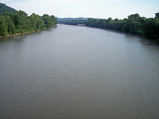
The Muskingum River is a tributary of the Ohio River, approximately 111 miles (179 km) long, in southeastern Ohio in the United States. An important commercial route in the 19th century, it flows generally southward through the eastern hill country of Ohio. Via the Ohio, it is part of the Mississippi River watershed. The river is navigable for much of its length through a series of locks and dams.
The Shawnee are a Native American people.

Southern Illinois, also known as Little Egypt, is a region of the U.S. state of Illinois comprising the southern third of the state, principally south of Interstate 70. Part of downstate Illinois, it is bordered by the two most voluminous rivers in the United States: the Mississippi below its connection with the Missouri River to the west and the Ohio River to the east and south, with the Wabash as a tributary.

The Hocking River is a 102-mile-long (164 km) right tributary of the Ohio River in southeastern Ohio in the United States.
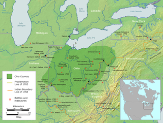
The Ohio Country, was a name used for a loosely defined region of colonial North America west of the Appalachian Mountains and south of Lake Erie.

The Great Miami River is a tributary of the Ohio River, approximately 160 miles (260 km) long, in southwestern Ohio and Indiana in the United States. The Great Miami originates at the man-made Indian Lake and flows south through the cities of Sidney, Piqua, Troy, Dayton, Middletown and Hamilton.

Lord Dunmore's War, also known as Dunmore's War, was a brief conflict in fall 1774 between the British Colony of Virginia and the Shawnee and Mingo in the trans-Appalachian region of the colony south of the Ohio River. Broadly, the war included events between May and October 1774. The governor of Virginia during the conflict was John Murray, 4th Earl of Dunmore, who in May 1774, asked the House of Burgesses to declare a state of war with the Indians and call out the Virginia militia.

The Tug Fork is a tributary of the Big Sandy River, 159 miles (256 km) long, in southwestern West Virginia, southwestern Virginia, and eastern Kentucky in the United States. Via the Big Sandy and Ohio rivers, it is part of the watershed of the Mississippi River.

The St. Marys River is a 99-mile-long (159 km) tributary of the Maumee River in northwestern Ohio and northeastern Indiana in the United States. Prior to development, it was part of the Great Black Swamp. Today, it drains a primarily rural farming region in the watershed of Lake Erie.

The Tradewater River is a tributary of the Ohio River, approximately 136 miles (219 km) long, in western Kentucky in the United States. It drains an area of 932 square miles (2,410 km2) in the limestone hills south of Evansville, Indiana, between the basins of the Cumberland River on the west and the Green River on the east.
Dover Township may refer to:
Duchouquet Township is one of the fourteen townships of Auglaize County, Ohio, United States. The 2020 census found 14,676 people in the township.

Shawnee State Park is a 3,983-acre (1,612 ha) Pennsylvania state park in Juniata and Napier Townships, Bedford County, Pennsylvania in the United States. Shawnee Lake, a 451-acre (183 ha) warm water reservoir, is at the center of the park as its main attraction. The park's main entrance is just east of Schellsburg, along U.S. Route 30 and about 10 miles (16 km) west of the county seat of Bedford. The park is also easily accessed via State Route 31 and by State Route 96.

Lower Shawneetown, also known as Shannoah or Sonnontio, was an 18th-century Shawnee village located within the Lower Shawneetown Archeological District, near South Portsmouth in Greenup County, Kentucky and Lewis County, Kentucky. The population eventually occupied areas on both sides of the Ohio River, and along both sides of the Scioto River in what is now Scioto County, Ohio. It was added to the National Register of Historic Places on 28 April 1983. It is near the Bentley site, a Madisonville Horizon settlement inhabited between 1400 CE and 1625 CE. Nearby, to the east, there are also four groups of Hopewell tradition mounds, built between 100 BCE and 500 CE, known as the Portsmouth Earthworks.

Concord Township is one of the eighteen townships of Delaware County, Ohio, United States. The 2020 census found 11,207 people in the township.
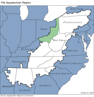
Appalachian Ohio is a bioregion and political unit in the southeastern part of the U.S. state of Ohio, characterized by the western foothills of the Appalachian Mountains and the Appalachian Plateau. The Appalachian Regional Commission defines the region as consisting of thirty-two counties. This region roughly overlaps with the Appalachian mixed-mesophytic forests, which begin in southeast Ohio and southwest Pennsylvania and continue south to Georgia and Alabama. The mixed-mesophytic forest is found only in Central and Southern Appalachia and eastern/central China. It is one of the most biodiverse temperate forests in the world.
Auburn Township may refer to:
Shawnee Township may refer to the following places in the United States: