
Limestone is a type of carbonate sedimentary rock which is the main source of the material lime. It is composed mostly of the minerals calcite and aragonite, which are different crystal forms of CaCO3. Limestone forms when these minerals precipitate out of water containing dissolved calcium. This can take place through both biological and nonbiological processes, though biological processes, such as the accumulation of corals and shells in the sea, have likely been more important for the last 540 million years. Limestone often contains fossils which provide scientists with information on ancient environments and on the evolution of life.
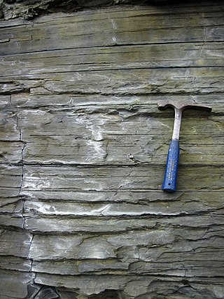
Shale is a fine-grained, clastic sedimentary rock formed from mud that is a mix of flakes of clay minerals (hydrous aluminium phyllosilicates, e.g. kaolin, Al2Si2O5(OH)4) and tiny fragments (silt-sized particles) of other minerals, especially quartz and calcite. Shale is characterized by its tendency to split into thin layers (laminae) less than one centimeter in thickness. This property is called fissility. Shale is the most common sedimentary rock.

Sedimentary rocks are types of rock that are formed by the accumulation or deposition of mineral or organic particles at Earth's surface, followed by cementation. Sedimentation is the collective name for processes that cause these particles to settle in place. The particles that form a sedimentary rock are called sediment, and may be composed of geological detritus (minerals) or biological detritus. The geological detritus originated from weathering and erosion of existing rocks, or from the solidification of molten lava blobs erupted by volcanoes. The geological detritus is transported to the place of deposition by water, wind, ice or mass movement, which are called agents of denudation. Biological detritus was formed by bodies and parts of dead aquatic organisms, as well as their fecal mass, suspended in water and slowly piling up on the floor of water bodies. Sedimentation may also occur as dissolved minerals precipitate from water solution.
Sediment is a naturally occurring material that is broken down by processes of weathering and erosion, and is subsequently transported by the action of wind, water, or ice or by the force of gravity acting on the particles. For example, sand and silt can be carried in suspension in river water and on reaching the sea bed deposited by sedimentation; if buried, they may eventually become sandstone and siltstone through lithification.
Sedimentology encompasses the study of modern sediments such as sand, silt, and clay, and the processes that result in their formation, transport, deposition and diagenesis. Sedimentologists apply their understanding of modern processes to interpret geologic history through observations of sedimentary rocks and sedimentary structures.

In geology, rock is any naturally occurring solid mass or aggregate of minerals or mineraloid matter. It is categorized by the minerals included, its chemical composition, and the way in which it is formed. Rocks form the Earth's outer solid layer, the crust, and most of its interior, except for the liquid outer core and pockets of magma in the asthenosphere. The study of rocks involves multiple subdisciplines of geology, including petrology and mineralogy. It may be limited to rocks found on Earth, or it may include planetary geology that studies the rocks of other celestial objects.

Tektites are gravel-sized bodies composed of black, green, brown or grey natural glass formed from terrestrial debris ejected during meteorite impacts. The term was coined by Austrian geologist Franz Eduard Suess (1867–1941), son of Eduard Suess. They generally range in size from millimetres to centimetres. Millimetre-scale tektites are known as microtektites.
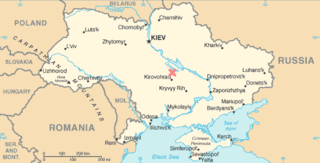
The Boltysh crater or Bovtyshka crater is a buried impact crater in the Kirovohrad Oblast of Ukraine, near the village of Bovtyshka. The crater is 24 kilometres (15 mi) in diameter and its age of 65.39 ± 0.14/0.16 million years, based on argon-argon dating techniques, less than 1 million years younger than Chicxulub crater in Mexico and the Cretaceous–Paleogene boundary. The Chicxulub impact is believed to have caused the mass extinction at the end of the Cretaceous period, which included the extinction of the non-avian dinosaurs. The Boltysh crater is currently thought to be unrelated to the Chicxulub impact, and to have not generated major global environmental effects.

Relative dating is the science of determining the relative order of past events, without necessarily determining their absolute age. In geology, rock or superficial deposits, fossils and lithologies can be used to correlate one stratigraphic column with another. Prior to the discovery of radiometric dating in the early 20th century, which provided a means of absolute dating, archaeologists and geologists used relative dating to determine ages of materials. Though relative dating can only determine the sequential order in which a series of events occurred, not when they occurred, it remains a useful technique. Relative dating by biostratigraphy is the preferred method in paleontology and is, in some respects, more accurate. The Law of Superposition, which states that older layers will be deeper in a site than more recent layers, was the summary outcome of 'relative dating' as observed in geology from the 17th century to the early 20th century.

Mudrocks are a class of fine-grained siliciclastic sedimentary rocks. The varying types of mudrocks include siltstone, claystone, mudstone, slate, and shale. Most of the particles of which the stone is composed are less than 1⁄16 mm and are too small to study readily in the field. At first sight, the rock types appear quite similar; however, there are important differences in composition and nomenclature.

Clastic rocks are composed of fragments, or clasts, of pre-existing minerals and rock. A clast is a fragment of geological detritus, chunks, and smaller grains of rock broken off other rocks by physical weathering. Geologists use the term clastic to refer to sedimentary rocks and particles in sediment transport, whether in suspension or as bed load, and in sediment deposits.

In sedimentology and geology, a nodule is a small, irregularly rounded knot, mass, or lump of a mineral or mineral aggregate that typically has a contrasting composition, such as a pyrite nodule in coal, a chert nodule in limestone, or a phosphorite nodule in marine shale, from the enclosing sediment or sedimentary rock. Normally, a nodule has a warty or knobby surface and exists as a discrete mass within the host strata. In general, they lack any internal structure except for the preserved remnants of original bedding or fossils. Nodules are closely related to concretions and sometimes these terms are used interchangeably. Minerals that typically form nodules include calcite, chert, apatite (phosphorite), anhydrite, and pyrite.

Marine sediment, or ocean sediment, or seafloor sediment, are deposits of insoluble particles that have accumulated on the seafloor. These particles have their origins in soil and rocks and have been transported from the land to the sea, mainly by rivers but also by dust carried by wind and by the flow of glaciers into the sea. Additional deposits come from marine organisms and chemical precipitation in seawater, as well as from underwater volcanoes and meteorite debris.
Sedimentary structures include all kinds of features in sediments and sedimentary rocks, formed at the time of deposition.

Pilot Knob is the eroded core of an extinct volcano located 8 miles (13 km) south of central Austin, Texas, near Austin-Bergstrom International Airport and McKinney Falls State Park.

Mudcracks are sedimentary structures formed as muddy sediment dries and contracts. Crack formation also occurs in clay-bearing soils as a result of a reduction in water content.
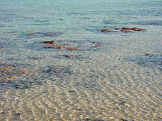
Shallow water marine environment refers to the area between the shore and deeper water, such as a reef wall or a shelf break. This environment is characterized by oceanic, geological and biological conditions, as described below. The water in this environment is shallow and clear, allowing the formation of different sedimentary structures, carbonate rocks, coral reefs, and allowing certain organisms to survive and become fossils.
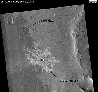
The geological history of Mars follows the physical evolution of Mars as substantiated by observations, indirect and direct measurements, and various inference techniques. Methods dating back to 17th century techniques developed by Nicholas Steno, including the so-called law of superposition and stratigraphy, used to estimate the geological histories of Earth and the Moon, are being actively applied to the data available from several Martian observational and measurement resources. These include the landers, orbiting platforms, Earth-based observations, and Martian meteorites.
The geology of Estonia is the study of rocks, minerals, water, landforms and geologic history in Estonia. The crust is part of the East European Craton and formed beginning in the Paleoproterozoic nearly two billion years ago. Shallow marine environments predominated in Estonia, producing extensive natural resources from organic matter such as oil shale and phosphorite. The Mesozoic and much of the Cenozoic are not well-preserved in the rock record, although the glaciations during the Pleistocene buried deep valleys in sediment, rechanneled streams and left a landscape of extensive lakes and peat bogs.
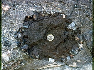
An armored mud ball is a small sedimentary structure, formed in flowing water, which consists of a fragment of clay or mud that has been rolled by currents into a spherical shape, and which then becomes coated in a layer of sand, gravel or pebbles that serves to protect (armor) it against further breakdown. Armored mud balls can vary in size from less than a centimeters up to 50 centimeters in diameter. Typically, they are between 5 and 10 centimeters in diameter. Mud balls are known to form in many parts of the world, and armored mud balls can form in river, lake or marine environments.


