Geology is a branch of natural science concerned with the Earth and other astronomical objects, the rocks of which they are composed, and the processes by which they change over time. Modern geology significantly overlaps all other Earth sciences, including hydrology. It is integrated with Earth system science and planetary science.
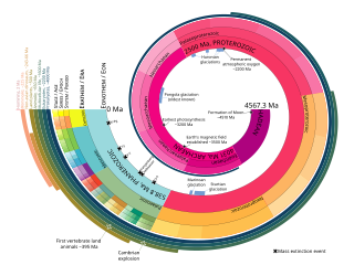
The geologic time scale or geological time scale (GTS) is a representation of time based on the rock record of Earth. It is a system of chronological dating that uses chronostratigraphy and geochronology. It is used primarily by Earth scientists to describe the timing and relationships of events in geologic history. The time scale has been developed through the study of rock layers and the observation of their relationships and identifying features such as lithologies, paleomagnetic properties, and fossils. The definition of standardised international units of geologic time is the responsibility of the International Commission on Stratigraphy (ICS), a constituent body of the International Union of Geological Sciences (IUGS), whose primary objective is to precisely define global chronostratigraphic units of the International Chronostratigraphic Chart (ICC) that are used to define divisions of geologic time. The chronostratigraphic divisions are in turn used to define geochronologic units.

Sedimentary rocks are types of rock that are formed by the accumulation or deposition of mineral or organic particles at Earth's surface, followed by cementation. Sedimentation is the collective name for processes that cause these particles to settle in place. The particles that form a sedimentary rock are called sediment, and may be composed of geological detritus (minerals) or biological detritus. The geological detritus originated from weathering and erosion of existing rocks, or from the solidification of molten lava blobs erupted by volcanoes. The geological detritus is transported to the place of deposition by water, wind, ice or mass movement, which are called agents of denudation. Biological detritus was formed by bodies and parts of dead aquatic organisms, as well as their fecal mass, suspended in water and slowly piling up on the floor of water bodies. Sedimentation may also occur as dissolved minerals precipitate from water solution.
Sedimentology encompasses the study of modern sediments such as sand, silt, and clay, and the processes that result in their formation, transport, deposition and diagenesis. Sedimentologists apply their understanding of modern processes to interpret geologic history through observations of sedimentary rocks and sedimentary structures.

Stratigraphy is a branch of geology concerned with the study of rock layers (strata) and layering (stratification). It is primarily used in the study of sedimentary and layered volcanic rocks. Stratigraphy has three related subfields: lithostratigraphy, biostratigraphy, and chronostratigraphy.

Geochronology is the science of determining the age of rocks, fossils, and sediments using signatures inherent in the rocks themselves. Absolute geochronology can be accomplished through radioactive isotopes, whereas relative geochronology is provided by tools such as paleomagnetism and stable isotope ratios. By combining multiple geochronological indicators the precision of the recovered age can be improved.
Historical geology or palaeogeology is a discipline that uses the principles and methods of geology to reconstruct the geological history of Earth. Historical geology examines the vastness of geologic time, measured in billions of years, and investigates changes in the Earth, gradual and sudden, over this deep time. It focuses on geological processes, such as plate tectonics, that have changed the Earth's surface and subsurface over time and the use of methods including stratigraphy, structural geology, paleontology, and sedimentology to tell the sequence of these events. It also focuses on the evolution of life during different time periods in the geologic time scale.

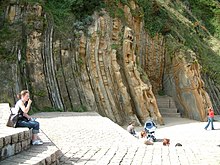
An unconformity is a buried erosional or non-depositional surface separating two rock masses or strata of different ages, indicating that sediment deposition was not continuous. In general, the older layer was exposed to erosion for an interval of time before deposition of the younger layer, but the term is used to describe any break in the sedimentary geologic record. The significance of angular unconformity was shown by James Hutton, who found examples of Hutton's Unconformity at Jedburgh in 1787 and at Siccar Point in Berwickshire in 1788, both in Scotland.

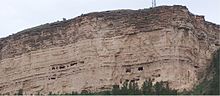
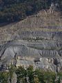
The law of superposition is an axiom that forms one of the bases of the sciences of geology, archaeology, and other fields pertaining to geological stratigraphy. In its plainest form, it states that in undeformed stratigraphic sequences, the oldest strata will lie at the bottom of the sequence, while newer material stacks upon the surface to form new deposits over time. This is paramount to stratigraphic dating, which requires a set of assumptions, including that the law of superposition holds true and that an object cannot be older than the materials of which it is composed. To illustrate the practical applications of superposition in scientific inquiry, sedimentary rock that has not been deformed by more than 90° will exhibit the oldest layers on the bottom, thus enabling paleontologists and paleobotanists to identify the relative ages of any fossils found within the strata, with the remains of the most archaic lifeforms confined to the lowest. These findings can inform the community on the fossil record covering the relevant strata, to determine which species coexisted temporally and which species existed successively in perhaps an evolutionarily or phylogenetically relevant way.

Biostratigraphy is the branch of stratigraphy which focuses on correlating and assigning relative ages of rock strata by using the fossil assemblages contained within them. The primary objective of biostratigraphy is correlation, demonstrating that a particular horizon in one geological section represents the same period of time as another horizon at a different section. Fossils within these strata are useful because sediments of the same age can look completely different, due to local variations in the sedimentary environment. For example, one section might have been made up of clays and marls, while another has more chalky limestones. However, if the fossil species recorded are similar, the two sediments are likely to have been laid down around the same time. Ideally these fossils are used to help identify biozones, as they make up the basic biostratigraphy units, and define geological time periods based upon the fossil species found within each section.
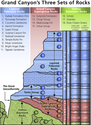
A geological formation, or simply formation, is a body of rock having a consistent set of physical characteristics (lithology) that distinguishes it from adjacent bodies of rock, and which occupies a particular position in the layers of rock exposed in a geographical region. It is the fundamental unit of lithostratigraphy, the study of strata or rock layers.
Lithostratigraphy is a sub-discipline of stratigraphy, the geological science associated with the study of strata or rock layers. Major focuses include geochronology, comparative geology, and petrology.
Relative dating is the science of determining the relative order of past events, without necessarily determining their absolute age. In geology, rock or superficial deposits, fossils and lithologies can be used to correlate one stratigraphic column with another. Prior to the discovery of radiometric dating in the early 20th century, which provided a means of absolute dating, archaeologists and geologists used relative dating to determine ages of materials. Though relative dating can only determine the sequential order in which a series of events occurred, not when they occurred, it remains a useful technique. Relative dating by biostratigraphy is the preferred method in paleontology and is, in some respects, more accurate. The Law of Superposition, which states that older layers will be deeper in a site than more recent layers, was the summary outcome of 'relative dating' as observed in geology from the 17th century to the early 20th century.
Chronostratigraphy is the branch of stratigraphy that studies the ages of rock strata in relation to time.

In geology, a bed is a layer of sediment, sedimentary rock, or volcanic rock "bounded above and below by more or less well-defined bedding surfaces". Specifically in sedimentology, a bed can be defined in one of two major ways. First, Campbell and Reineck and Singh use the term bed to refer to a thickness-independent layer comprising a coherent layer of sedimentary rock, sediment, or pyroclastic material bounded above and below by surfaces known as bedding planes. By this definition of bed, laminae are small beds that constitute the smallest (visible) layers of a hierarchical succession and often, but not always, internally comprise a bed.
This glossary of geology is a list of definitions of terms and concepts relevant to geology, its sub-disciplines, and related fields. For other terms related to the Earth sciences, see Glossary of geography terms.
In stratigraphy and geology, an eonothem is the totality of rock strata laid down in the stratigraphic record deposited during a certain eon of the continuous geologic timescale. The eonothem is not to be confused with the eon itself, which is a corresponding division of geologic time spanning a specific number of years, during which rocks were formed that are classified within the eonothem. Eonothems have the same names as their corresponding eons, which means during the history of the Earth only four eonothems were formed. Oldest to newest these are the Hadean, Archean, Proterozoic, and Phanerozoic. A rock stratum, fossil or feature present in the "upper Phanerozoic" eonothem would therefore have originated within the "later Phanerozoic" eon. In practice, the rock column is discontinuous:
Technically, a complete geologic record doesn't occur anywhere. For such a record to develop would require the area to have been receiving sedimentary deposits continually ever since the origin of the earth. Nowhere is such a situation known to exist. If it did exist, we could not effectively look at the strata because they would still be buried, and modern strata would continue to be deposited on top of them. The earth's surface has been far too dynamic to allow that to occur anywhere. No area has been in such a static condition throughout the earth's long history. Areas that have had sediment deposited on them at one time are later uplifted and eroded. In some places this has occurred many times. There is ample evidence to prove such a sequence of events.
In stratigraphy, paleontology, geology, and geobiology, an erathem is the total stratigraphic unit deposited during a certain corresponding span of time during an era in the geologic timescale.
Magnetostratigraphy is a geophysical correlation technique used to date sedimentary and volcanic sequences. The method works by collecting oriented samples at measured intervals throughout the section. The samples are analyzed to determine their characteristic remanent magnetization (ChRM), that is, the polarity of Earth's magnetic field at the time a stratum was deposited. This is possible because volcanic flows acquire a thermoremanent magnetization and sediments acquire a depositional remanent magnetization, both of which reflect the direction of the Earth's field at the time of formation. This technique is typically used to date sequences that generally lack fossils or interbedded igneous rock. It is particularly useful in high-resolution correlation of deep marine stratigraphy where it allowed the validation of the Vine–Matthews–Morley hypothesis related to the theory of plate tectonics.
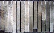
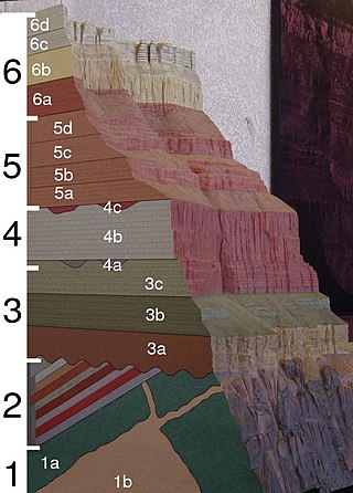
A stratigraphic column is a representation used in geology and its subfield of stratigraphy to describe the vertical location of rock units in a particular area. A typical stratigraphic column shows a sequence of sedimentary rocks, with the oldest rocks on the bottom and the youngest on top.