Geophysics is a subject of natural science concerned with the physical processes and physical properties of the Earth and its surrounding space environment, and the use of quantitative methods for their analysis. Geophysicists, who usually study geophysics, physics, or one of the Earth sciences at the graduate level, complete investigations across a wide range of scientific disciplines. The term geophysics classically refers to solid earth applications: Earth's shape; its gravitational, magnetic fields, and electromagnetic fields ; its internal structure and composition; its dynamics and their surface expression in plate tectonics, the generation of magmas, volcanism and rock formation. However, modern geophysics organizations and pure scientists use a broader definition that includes the water cycle including snow and ice; fluid dynamics of the oceans and the atmosphere; electricity and magnetism in the ionosphere and magnetosphere and solar-terrestrial physics; and analogous problems associated with the Moon and other planets.
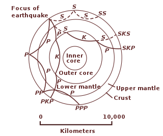
Seismic tomography or seismotomography is a technique for imaging the subsurface of the Earth using seismic waves. The properties of seismic waves are modified by the material through which they travel. By comparing the differences in seismic waves recorded at different locations, it is possible to create a model of the subsurface structure. Most commonly, these seismic waves are generated by earthquakes or man-made sources such as explosions. Different types of waves, including P, S, Rayleigh, and Love waves can be used for tomographic images, though each comes with their own benefits and downsides and are used depending on the geologic setting, seismometer coverage, distance from nearby earthquakes, and required resolution. The model created by tomographic imaging is almost always a seismic velocity model, and features within this model may be interpreted as structural, thermal, or compositional variations. Geoscientists apply seismic tomography to a wide variety of settings in which the subsurface structure is of interest, ranging in scale from whole-Earth structure to the upper few meters below the surface.

Reflection seismology is a method of exploration geophysics that uses the principles of seismology to estimate the properties of the Earth's subsurface from reflected seismic waves. The method requires a controlled seismic source of energy, such as dynamite or Tovex blast, a specialized air gun or a seismic vibrator. Reflection seismology is similar to sonar and echolocation.
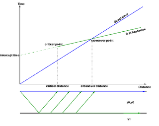
Seismic refraction is a geophysical principle governed by Snell's Law of refraction. The seismic refraction method utilizes the refraction of seismic waves by rock or soil layers to characterize the subsurface geologic conditions and geologic structure.
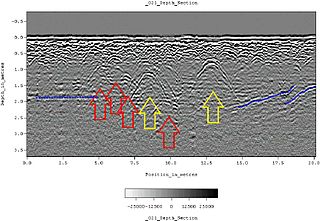
Ground-penetrating radar (GPR) is a geophysical method that uses radar pulses to image the subsurface. It is a non-intrusive method of surveying the sub-surface to investigate underground utilities such as concrete, asphalt, metals, pipes, cables or masonry. This nondestructive method uses electromagnetic radiation in the microwave band of the radio spectrum, and detects the reflected signals from subsurface structures. GPR can have applications in a variety of media, including rock, soil, ice, fresh water, pavements and structures. In the right conditions, practitioners can use GPR to detect subsurface objects, changes in material properties, and voids and cracks.
Exploration geophysics is an applied branch of geophysics and economic geology, which uses physical methods at the surface of the Earth, such as seismic, gravitational, magnetic, electrical and electromagnetic, to measure the physical properties of the subsurface, along with the anomalies in those properties. It is most often used to detect or infer the presence and position of economically useful geological deposits, such as ore minerals; fossil fuels and other hydrocarbons; geothermal reservoirs; and groundwater reservoirs. It can also be used to detect the presence of unexploded ordnance.

Magnetotellurics (MT) is an electromagnetic geophysical method for inferring the earth's subsurface electrical conductivity from measurements of natural geomagnetic and geoelectric field variation at the Earth's surface.

Electrical resistivity tomography (ERT) or electrical resistivity imaging (ERI) is a geophysical technique for imaging sub-surface structures from electrical resistivity measurements made at the surface, or by electrodes in one or more boreholes. If the electrodes are suspended in the boreholes, deeper sections can be investigated. It is closely related to the medical imaging technique electrical impedance tomography (EIT), and mathematically is the same inverse problem. In contrast to medical EIT, however, ERT is essentially a direct current method. A related geophysical method, induced polarization, measures the transient response and aims to determine the subsurface chargeability properties.
Transient electromagnetics,, is a geophysical exploration technique in which electric and magnetic fields are induced by transient pulses of electric current and the subsequent decay response measured. TEM / TDEM methods are generally able to determine subsurface electrical properties, but are also sensitive to subsurface magnetic properties in applications like UXO detection and characterization. TEM/TDEM surveys are a very common surface EM technique for mineral exploration, groundwater exploration, and for environmental mapping, used throughout the world in both onshore and offshore applications.
Induced polarization (IP) is a geophysical imaging technique used to identify the electrical chargeability of subsurface materials, such as ore.
Seismic migration is the process by which seismic events are geometrically re-located in either space or time to the location the event occurred in the subsurface rather than the location that it was recorded at the surface, thereby creating a more accurate image of the subsurface. This process is necessary to overcome the limitations of geophysical methods imposed by areas of complex geology, such as: faults, salt bodies, folding, etc.
Geomathematics is the application of mathematical methods to solve problems in geosciences, including geology and geophysics, and particularly geodynamics and seismology.

Interferometry examines the general interference phenomena between pairs of signals in order to gain useful information about the subsurface. Seismic interferometry (SI) utilizes the crosscorrelation of signal pairs to reconstruct the impulse response of a given media. Papers by Keiiti Aki (1957), Géza Kunetz, and Jon Claerbout (1968) helped develop the technique for seismic applications and provided the framework upon which modern theory is based.

Seismic inversion involves the set of methods which seismologists use to infer properties through physical measurements. Surface-wave inversion is the method by which elastic properties, density, and thickness of layers in the subsurface are obtained through analysis of surface-wave dispersion. The entire inversion process requires the gathering of seismic data, the creation of dispersion curves, and finally the inference of subsurface properties.

Near-surface geophysics is the use of geophysical methods to investigate small-scale features in the shallow subsurface. It is closely related to applied geophysics or exploration geophysics. Methods used include seismic refraction and reflection, gravity, magnetic, electric, and electromagnetic methods. Many of these methods were developed for oil and mineral exploration but are now used for a great variety of applications, including archaeology, environmental science, forensic science, military intelligence, geotechnical investigation, treasure hunting, and hydrogeology. In addition to the practical applications, near-surface geophysics includes the study of biogeochemical cycles.
The following outline is provided as an overview of and topical guide to geophysics:
Forensic geophysics is a branch of forensic science and is the study, the search, the localization and the mapping of buried objects or elements beneath the soil or the water, using geophysics tools for legal purposes. There are various geophysical techniques for forensic investigations in which the targets are buried and have different dimensions. Geophysical methods have the potential to aid the search and the recovery of these targets because they can non-destructively and rapidly investigate large areas where a suspect, illegal burial or, in general, a forensic target is hidden in the subsoil. When in the subsurface there is a contrast of physical properties between a target and the material in which it is buried, it is possible to individuate and define precisely the concealing place of the searched target. It is also possible to recognize evidences of human soil occupation or excavation, both recent and older. Forensic geophysics is an evolving technique that is gaining popularity and prestige in law enforcement.
Hydrogeophysics is a cross-disciplinary area of research that uses geophysics to determine parameters and monitor processes for hydrological studies of matters such as water resources, contamination, and ecological studies. The field uses knowledge and researchers from geology, hydrology, physics, geophysics, engineering, statistics, and rock physics. It uses geophysics to provide quantitative information about hydrogeological parameters, using minimally invasive methods. Hydrogeophysics differs from geophysics in its specific uses and methods. Although geophysical knowledge and methods have existed and grown over the last half century for applications in mining and petroleum industries, hydrogeological study sites have different subsurface conditions than those industries. Thus, the geophysical methods for mapping subsurface properties combine with hydrogeology to use proper, accurate methods to map shallow hydrological study sites.
Susan Sharpless Hubbard is an American hydrologist and geophysicist, and Hubbard is the Deputy for Science and Technology at Oak Ridge National Laboratory. She was elected a member of the National Academy of Engineering in 2020 for contributions to hydrogeophysics, biogeophysics, and the geophysics of permafrost.
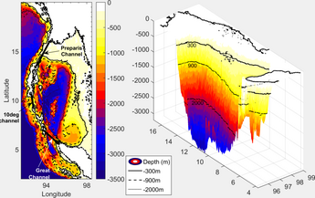
Subsurface mapping by ambient noise tomography is the mapping underground geological structures under the assistance of seismic signals. Ambient noise, which is not associated with the earthquake, is the background seismic signals. Given that the ambient noises have low frequencies in general, the further classification of ambient noise include secondary microseisms, primary microseisms, and seismic hum, based on different range of frequencies. We can utilize the ambient noise data collected by seismometers to create images for the subsurface under the following processes. Since the ambient noise is considered as diffuse wavefield, we can correlate the filtered ambient noise data from a pair of seismic stations to find the velocities of seismic wavefields. A 2-dimensional or 3-dimensional velocity map, showing the spatial velocity difference of the subsurface, can thus be created for observing the geological structures. Subsurface mapping by ambient noise tomography can be applied in different fields, such as detecting the underground void space, monitoring landslides, and mapping the crustal and upper mantle structure.