
The Kankakee River is a tributary of the Illinois River, approximately 133 miles (214 km) long, in the Central Corn Belt Plains of northwestern Indiana and northeastern Illinois in the United States. At one time, the river drained one of the largest wetlands in North America and furnished a significant portage between the Great Lakes and the Mississippi River. Significantly altered from its original channel, it flows through a primarily rural farming region of reclaimed cropland, south of Lake Michigan.
The Driftless Area, a region in the American Midwest, comprises southwestern Wisconsin, southeastern Minnesota, northeastern Iowa, and the extreme northwestern corner of Illinois. It was never covered by ice during the last ice age, and therefore lacks glacial deposits, also termed drift. Its landscape is characterized by steep hills, forested ridges, deeply carved river valleys, and karst geology with spring-fed waterfalls and cold-water trout streams. Ecologically, the Driftless Area's flora and fauna are more closely related to those of the Great Lakes region and New England than those of the broader Midwest and central Plains regions. The steep riverine landscape of both the Driftless Area proper and the surrounding Driftless-like region are the result of early glacial advances that forced preglacial rivers that flowed into the Great Lakes southward, causing them to carve a gorge across bedrock cuestas, thereby forming the modern incised upper Mississippi River valley. The region has elevations ranging from 603 to 1,719 feet at Blue Mound State Park, and together with the Driftless-like region, covers 24,000 square miles (62,200 km2).

P.J. Hoffmaster State Park is a public recreation area on the shores of Lake Michigan located five miles north of Grand Haven at the southwest corner of Norton Shores, in Muskegon County, and the northwest corner of Spring Lake Township, in Ottawa County, in the U.S. state of Michigan. It is operated by the Michigan Department of Natural Resources. The state park includes 1,200 acres (490 ha) of land including three miles (4.8 km) of sand beach on the lake.
Fred Meijer White Pine Trail State Park is a 92-mile (148 km) long linear state park in the U.S. state of Michigan.
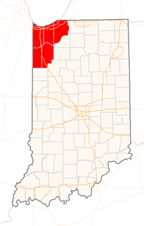
Northwest Indiana, nicknamed "The Region" after the Calumet Region, comprises Lake, Porter, LaPorte, Newton and Jasper counties in Indiana. This region neighbors Lake Michigan and is partially apart of Chicagoland. According to the 2010 Census, Northwest Indiana has a population of 819,537 and is the state's second largest urban area after the Indianapolis Metropolitan Area. It is also the home of the Indiana Dunes, parts of which have been preserved through conservation efforts. The town of Ogden Dunes houses the Hour Glass, a museum showcasing the ecological and conservation efforts of O. D. Frank.

Grand Mere State Park is a public recreation and nature preservation area in the southwestern part of the U.S. state of Michigan near Stevensville. The state park is located adjacent to Interstate 94. Protected from Lake Michigan by the dunes to the west, the park has many natural features not found throughout the rest of the state. In 1968 it was designated a National Natural Landmark.

Negwegon State Park is an undeveloped public recreation area on Lake Huron lying five miles (8.0 km) southeast of the unincorporated community of Ossineke in Alpena County and Alcona County, Michigan. The state park's 4,118 acres (1,666 ha) occupy the southern tip of Thunder Bay, fourteen miles (23 km) across the water from the city of Alpena. The park includes lowland areas with small ridges, mature pine forest, open meadows, and a long sand beach. It is administered by the Michigan Department of Natural Resources with support from the volunteer "Friends of Negwegon."
Silver Lake State Park is a public recreation area covering 2,936 acres (1,188 ha) that border Lake Michigan and Silver Lake, four miles (6.4 km) west of Mears in Oceana County, Michigan. The state park is composed of mature forest land and over 2,000 acres (810 ha) of sand dunes.

The Michigan Department of Natural Resources (DNR) is the agency of the state of Michigan charged with maintaining natural resources such as state parks, state forests, and recreation areas. It is governed by a director appointed by the Governor and accepted by the Natural Resources Commission. Currently the Director is Daniel Eichinger. The DNR has about 1,400 permanent employees, and over 1,600 seasonal employees.

The Au Sable State Forest is a state forest in the north-central Lower Peninsula of Michigan. It is operated by the Michigan Department of Natural Resources.

Pinckney State Recreation Area is a Michigan state recreation area in Dexter, Sylvan and Lyndon Townships, Washtenaw County and Putnam and Unadilla Townships, Livingston County in the U.S. state of Michigan. The park is 11,000 acres (4,500 ha) and sits at an elevation of 922 feet (281 m). The park is connected to the nearby Waterloo State Recreation Area by the 35-mile (56 km) Waterloo–Pinckney Trail. Pinckney State Recreation Area is open for year-round recreation including hiking, fishing, swimming, hunting and a variety of winter sports.

Pointe Mouillee State Game Area is a state game area in the U.S. state of Michigan. It encompasses 7,483 acres (30.3 km2) of hunting, recreational, and protected wildlife and wetland areas at the mouth of the Huron River at Lake Erie, as well as smaller outlying areas within the Detroit River. Pointe Mouillee State Game Area was established in 1945 and is administered by the Michigan Department of Natural Resources.
Chiwaukee Prairie is a 485-acre (1.96 km2) prairie in Pleasant Prairie, Wisconsin managed by the Wisconsin Department of Natural Resources. It is located on Lake Michigan at the Illinois state line and includes grassy wetlands, wooded areas, and the Kenosha Sand Dunes at its northern tip. It is home to an abundance of wildlife. It was designated a Wisconsin State Natural Area in 1967 and a National Natural Landmark in 1973.

The Dead Stream Flooding State Wildlife Management Area is a protected wildlife area located in the U.S. state of Michigan. The wildlife management area centers along the Muskegon River about 2 miles (3.2 km) from its source at Houghton Lake. It incorporates rural areas in Enterprise Township within Missaukee County and Lake Township within Roscommon County for an approximate total area of 1,024 acres (4.14 km2). It is controlled and maintained by the Michigan Department of Natural Resources.

The Houghton Lake Flats Flooding State Wildlife Management Area is a protected wildlife area located in rural Lake Township within Roscommon County in the U.S. state of Michigan. The wildlife management area incorporates 1,830 acres (7.41 km2) of artificially restored marsh and wetlands just west of Houghton Lake.
The Maple River State Game Area is a protected state game area in the U.S. state of Michigan. Located in the central region of the Lower Peninsula, it encompasses approximately 9,252 acres (3,744 ha) in segmented portions within Clinton, Gratiot, and Ionia counties. Governed by the Michigan Department of Natural Resources, the area is considered the state's longest contiguous wetland complex.

Backus Creek State Game Area is a state game area within Roscommon County in the U.S. state of Michigan. It incorporates 4,379 acres (17.72 km2) of hunting, recreational, and protected wildlife and wetland areas of rural Backus Township and Higgins Township. Backus Creek State Game Area is administered by the Michigan Department of Natural Resources (MDNR).
