Round Island Channel

Last updated

The Round Island Channel is a navigable Lake Huron waterway located between Mackinac Island and Round Island in the Straits of Mackinac. It forms a key link in the lake freighter route between Lake Superior and Lake Michigan, on which millions of tons of taconite iron ore are shipped annually. The channel also provides access to the harbor of Mackinac Island, Michigan, and is used by commercial ferryboats delivering passengers to the small island city.

Contents

In history

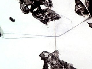
Satellite photograph of icebreaker paths for shipping, including the Round Island Channel on the upper right-hand corner of the image. StraitsMackinac ISS010-E-20813.jpg
Satellite photograph of icebreaker paths for shipping, including the Round Island Channel on the upper right-hand corner of the image.

The Round Island Channel has been in active use since before the arrival of European explorers. With the construction of Fort Mackinac in 1780–1781, the channel became a link in the logistics chain operated by the British Army to supply the fort.

With the discovery of significant hematite mines in northern Minnesota in the late 1800s, and the construction of steel mills shortly after 1900 along the shores of southern Lake Michigan in and around Gary, Indiana, the Round Island Channel became an essential element in one of the most significant commodity supply pipelines of the Great Lakes.

The Round Island Channel is lit by Round Island Light, an 1895 lighthouse, and by Round Island Passage Light, a 1948 light which has a Racon.

The channel is maintained to a project depth of 30 feet (9.1 meters) in line with U.S.-Canadian agreements governing the operation of Great Lakes navigable waterways and the St. Lawrence Seaway. This depth is sufficient to provide safe water for lake freighters as massive as 1,000 feet (300 m) long. Buoys and the lights delineate the channel today. [1]

In sports

The Round Island Channel forms the ending points of the annual Chicago Yacht Club Race to Mackinac and its counterpart, the Port Huron to Mackinac Race. In both races, sail-powered yachts race from the southern ends of Lake Michigan and Lake Huron, respectively, to the Round Island Channel.

Related Research Articles

<span class="mw-page-title-main">Lake Michigan</span> One of the Great Lakes of North America

Lake Michigan is one of the five Great Lakes of North America. It is the second-largest of the Great Lakes by volume and the third-largest by surface area, after Lake Superior and Lake Huron. To the east, its basin is conjoined with that of Lake Huron through the 3+12 miles wide, 295 feet deep, Straits of Mackinac, giving it the same surface elevation as its easterly counterpart; the two are technically a single lake.

<span class="mw-page-title-main">Lake Huron</span> One of the Great Lakes of North America

Lake Huron is one of the five Great Lakes of North America. Hydrologically, it comprises the easterly portion of Lake Michigan–Huron, having the same surface elevation as Lake Michigan, to which it is connected by the 5-mile-wide (8.0 km), 20-fathom-deep Straits of Mackinac. It is shared on the north and east by the Canadian province of Ontario and on the south and west by the U.S. state of Michigan. The name of the lake is derived from early French explorers who named it for the Huron people inhabiting the region.

<span class="mw-page-title-main">Mackinac Island</span> Island in Michigan, United States

Mackinac Island is an island and resort area, covering 4.35 square miles (11.3 km2) in land area, in the U.S. state of Michigan. The name of the island in Odawa is Michilimackinac and "Mitchimakinak" in Ojibwemowin meaning "Big Turtle". It is located in Lake Huron, at the eastern end of the Straits of Mackinac, between the state's Upper and Lower Peninsulas. The island was long home to an Odawa settlement and previous indigenous cultures before European colonization began in the 17th century. It was a strategic center of the fur trade around the Great Lakes. Based on a former trading post, Fort Mackinac was constructed on the island by the British during the American Revolutionary War. It was the site of two battles during the War of 1812 before the northern border was settled and the US gained this island in its territory.

<span class="mw-page-title-main">Great Lakes Waterway</span> System of channels and canals in the Great Lakes

The Great Lakes Waterway (GLW) is a system of natural channels and artificial canals which enable navigation between the North American Great Lakes. Though all of the lakes are naturally connected as a chain, water travel between the lakes was impeded for centuries by obstacles such as Niagara Falls and the rapids of the St. Marys River.

<span class="mw-page-title-main">Mackinac Island, Michigan</span> Historic resort community on a Michigan island

Mackinac Island is a city in Mackinac County in the U.S. state of Michigan. As of the 2020 census, the city had a permanent population of 583. The population numbers in the tens of thousands from May 1st to October 31st due to an influx of visitors and hundreds of seasonal workers.

Mackinac or Mackinaw may refer to:

<span class="mw-page-title-main">Lake St. Clair</span> Lake bordering Ontario, Canada and Michigan, US

Lake St. Clair is a freshwater lake that lies between the Canadian province of Ontario and the U.S. state of Michigan. It was named in 1679 by French Catholic explorers after Saint Clare of Assisi, on whose feast day they first saw the lake.

<span class="mw-page-title-main">Straits of Mackinac</span> Strait connecting Lakes Huron and Michigan in Michigan, USA

The Straits of Mackinac are the short waterways between the U.S. state of Michigan's Upper and Lower Peninsulas, traversed by the Mackinac Bridge. The main strait is 3+12 miles wide with a maximum depth of 295 feet, and connects two of the Great Lakes, Lake Michigan and Lake Huron. Hydrologically, the two connected lakes are one body of water, known as Lake Michigan–Huron. Historically, the native Odawa people called the region around the Straits Michilimackinac.

<span class="mw-page-title-main">Fort Holmes</span> United States historic place

Fort Holmes is a fortified earthen redoubt located on the highest point of Mackinac Island. Originally built in 1814 by British forces during the War of 1812, the redoubt was improved by that army throughout the course of the war (1812–1814) to help defend the adjacent Fort Mackinac from a possible attack by the U.S. Army.

The Thumb is a region and a peninsula of the U.S. state of Michigan, so named because the Lower Peninsula is shaped like a mitten. The Thumb area is generally considered to be in the Central Michigan region, east of the Tri-Cities and north of Metro Detroit. The region is also branded as the Blue Water Area.

<span class="mw-page-title-main">Little Traverse Bay</span> Bay on Lake Michigan in Emmet County, Michigan, United States

Little Traverse Bay is a small open bay of Lake Michigan. Extending about 10 miles (16 km) into the Lower Peninsula of Michigan, much of the head of the land surrounding Little Traverse Bay, and has become part of the urban areas of Petoskey and Harbor Springs. Little Traverse Bay primarily lies within Emmet County, although a small portion lies within Charlevoix County.

<span class="mw-page-title-main">Lake Michigan–Huron</span> Combined lake system in North America

Lake Michigan–Huron is the body of water combining both Lake Michigan and Lake Huron, which are joined through the 5-mile-wide (8.0 km), 295-foot-deep (90 m), open-water Straits of Mackinac. Huron and Michigan are hydrologically a single lake because the flow of water through the straits keeps their water levels in overall equilibrium. Although the flow is generally eastward, the water moves in either direction depending on local conditions. Combined, Lake Michigan–Huron is the largest freshwater lake by area in the world. However, Lake Superior is larger than either individually, and so is counted as the largest lake when Lake Huron and Lake Michigan are considered separately.

<span class="mw-page-title-main">Port Huron to Mackinac Boat Race</span>

The Bayview Mackinac Boat Race is run by the Bayview Yacht Club of Detroit, Michigan. It is one of the longest fresh-water races in the world with over two hundred boats entering the race each year.

<span class="mw-page-title-main">Old Mackinac Point Light</span> Lighthouse in Michigan, United States

Old Mackinac Point Light is a deactivated lighthouse located at the northern tip of the Lower Peninsula in the U.S. state of Michigan. The lighthouse is part of Fort Michilimackinac State Park in the village of Mackinaw City just east of the Mackinac Bridge.

<span class="mw-page-title-main">Round Island Light, Michigan</span> Lighthouse in Michigan, United States

For the lighthouse of the same name in the St. Mary's River, see Round Island Light

<span class="mw-page-title-main">Cheboygan River</span> River in the United States

The Cheboygan River is a short but significant river in the Lake Huron drainage basin of the U.S. state of Michigan.

<span class="mw-page-title-main">Poe Reef Light</span> Lighthouse in Michigan, United States

Poe Reef is a lighthouse located at the east end of South Channel between Bois Blanc Island and the mainland of the Lower Peninsula, about 6 miles (9.7 km) east of Cheboygan, Michigan.

The DeTour Passage Underwater Preserve is a preservation area in the U.S. state of Michigan. Located in Lake Huron, it completely surrounds Drummond Island and includes all of DeTour Passage and adjacent sections of Lake Huron and the St. Mary's River.

<span class="mw-page-title-main">Round Island Passage Light</span> Lighthouse in Michigan, United States

Round Island Passage Light is an automated, unmanned lighthouse located in the Round Island Channel in the Straits of Mackinac, Michigan. The channel is a branch of Lake Huron.

The Super Mac is a non-periodic 568 mile sail boat race from Chicago, IL to Port Huron, MI, or vice versa. Recent editions have been jointly sponsored by the Chicago Yacht Club, Bayview Yacht Club and Port Huron Yacht Club. The 2015 race was promoted as "The Longest Fresh Water Race on Earth," a debatable claim.

References

  1. "Chart 14881:Inset: Mackinac Island (1/10,000)". NOAA. 2005.{{cite journal}}: Cite journal requires |journal= (help)

Coordinates: 45°50′27″N84°36′55″W / 45.8409°N 84.6154°W / 45.8409; -84.6154