
The Ontonagon River is a river flowing to Lake Superior on the western Upper Peninsula of Michigan in the United States. The main stem of the river is 25 miles (40 km) long and is formed by a confluence of several longer branches, portions of which have been collectively designated as a National Wild and Scenic River. Several waterfalls occur on the river including Agate Falls and Bond Falls.
The Brevoort River is a 9.8-mile-long (15.8 km) river on the Upper Peninsula of Michigan in the United States. It begins at the outlet of Brevoort Lake and flows in a highly winding course ultimately southwards to Lake Michigan.
The Little Brevoort River is a 14.7-mile-long (23.7 km) river on the Upper Peninsula of Michigan in the United States. It flows generally southeast to Brevoort Lake, the outlet of which is the Brevoort River, flowing to Lake Michigan.
The Little Sturgeon River is a 12.3-mile-long (19.8 km) river in Cheboygan County, Michigan, in the United States. It is a tributary of the Indian River, part of the Mullett Lake/Cheboygan River system flowing to Lake Huron.
The Little Two Hearted River is a 23.9-mile-long (38.5 km) river in Luce County on the Upper Peninsula of Michigan in the United States. It rises at the outlet of the Little Two Hearted Lakes at the southern border of Lake Superior State Forest and flows generally north to Lake Superior.
The Lower Millecoquins River is a 9.6-mile-long (15.4 km) river on the Upper Peninsula of Michigan in the United States. It begins at the outlet of Millecoquins Lake and flows in a winding course south to Lake Michigan. The principal inflow of Millecoquins Lake is the Upper Millecoquins River.
Millecoquins River may refer to a river in Michigan in the United States:
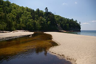
The Miners River is a river on the Upper Peninsula of Michigan in the United States. It is the largest river in the Pictured Rocks National Lakeshore. Miners River has its origin outside of the National Lakeshore, north of Indian Town in the Hiawatha National Forest, and flows 12.4 miles (20.0 km) into Lake Superior. Miners Lake and Miners Falls are found along the river. The river empties into Lake Superior at the western end of Miners Beach. It is popular for tourism and fishing.
The Moran River is a 2.2-mile-long (3.5 km) river on the Upper Peninsula of Michigan in the United States. It begins at the outlet of Chain Lake just west of St. Ignace and flows west through Freschette Lake to Lake Michigan at West Moran Bay.
The Murphy River is a 6.6-mile-long (10.6 km) river in Baraga County on the Upper Peninsula of Michigan in the United States. It is a tributary of Worm Lake, the outlet of which is the Rock River, which flows to the Sturgeon River and eventually to Lake Superior.
The Perch River is a 25.4-mile-long (40.9 km) tributary of the Sturgeon River in Iron County and Baraga County on the Upper Peninsula of Michigan in the United States. The Perch River begins at the outlet of Perch Lake in Bates Township and flows north through Ottawa National Forest to the Sturgeon River.

The Pointe aux Chenes River is a 6.2-mile-long (10.0 km) river on the Upper Peninsula of Michigan in the United States. It begins at the outlet of Round Lake and flows south in a winding course through the extensive Pointe aux Chenes Marshes to Lake Michigan.
The Sucker River is a 34.8-mile-long (56.0 km) river in eastern Alger County on the Upper Peninsula of Michigan in the United States. It rises at the outlet of Nawakwa Lake and flows generally north to Lake Superior east of Grand Marais.
The Tobacco River is a 14.0-mile-long (22.5 km) river in Keweenaw County on the Upper Peninsula of Michigan in the United States. It rises at the outlet of Thayer Lake and flows east, then south, to Lake Superior, which it joins near the village of Gay.
The Vermilac River is an 8.8-mile-long (14.2 km) river in Baraga County on the Upper Peninsula of Michigan in the United States. It is a tributary of Worm Lake, the outlet of which is the Rock River, which flows to the Sturgeon River and eventually to Lake Superior.

Indian River is a 59.1-mile-long (95.1 km) tributary of the Manistique River on the Upper Peninsula of Michigan in the United States. It rises out of Hovey Lake at 46°17′36″N86°42′20″W on Hiawatha National Forest land in Alger County and flows south and east through a lake district and on through Schoolcraft County. The river flows into the 8,659 acre (35 km²) Indian Lake at 46°17′36″N86°42′20″W and flows out at 45°59′30″N86°17′15″W. It then flows east and south about 2.5 miles where it merges with the Manistique River, which then flows through Manistique and into Lake Michigan at 45°56′56″N86°14′45″W.
The Carp River is a 1.2-mile-long (1.9 km) stream in the northeast corner of Luce County on the Upper Peninsula of Michigan in the United States. It flows west from the outlet of Browns Lake, to its mouth on Lake Superior.
The Rock River is a 6.1-mile-long (9.8 km) stream in Baraga County on the Upper Peninsula of Michigan in the United States. It rises at the outlet of Worm Lake, east of Covington, and flows northwest to the Sturgeon River, which continues west, then north to Portage Lake and Lake Superior. The Rock River descends 350 feet (110 m) over its 6-mile (10 km) course, for an average rate of 58 feet per mile.
The River Styx is a 0.6-mile-long (1.0 km) stream in Marquette County, Michigan, in the United States. It flows from the outlet of Ives Lake north over a waterfall to Third Lake, an arm of Pine Lake. Via the Pine River, water from the River Styx flows to Lake Superior.


