Port Sanilac Light

Last updated
Port Sanilac Light
Port Sanilac Light Station - Port Sanilac Michigan.jpg
Port Sanilac Light
Location Port Sanilac, Michigan
Coordinates 43°25′44″N82°32′24″W / 43.42889°N 82.54000°W / 43.42889; -82.54000
Tower
Constructed1886  OOjs UI icon edit-ltr-progressive.svg
Foundation dressed stone masonry/timber [1]
Construction Brick
Automated1928
Height59 feet (18 m) [2]
Shape Octagonal hourglass [3]
MarkingsWhite with red roof
HeritageNational Register of Historic Places listed place  OOjs UI icon edit-ltr-progressive.svg
Light
First lit1886 [4]
Focal height69 feet (21 m) [5]
LensFourth order Fresnel lens [6]
Range16 nautical miles (30 km; 18 mi) [7]
Characteristic Fl W 2.5 sec. [8]
Port Sanilac Light Station
LocationLake St., Port Sanilac, Michigan
Area0.3 acres (0.12 ha)
MPS U.S. Coast Guard Lighthouses and Light Stations on the Great Lakes TR
NRHP reference No. 84001842 [9]
Added to NRHPJuly 19, 1984

Port Sanilac Light is a United States Coast Guard lighthouse located on Point Sanilac, near Port Sanilac on the eastern side of Michigan's Thumb. [4] It is an automated and active aid to navigation on Lake Huron. [10] [11]

Contents

History

Characterized by shallow water and sandbanks, the 75-mile (121 km) stretch of coastline between the Fort Gratiot Light and Pointe aux Barques Light is a hazard to navigation. Even after the establishment of the Sand Beach Harbor of Refuge Light in 1875, 30 miles (48 km) of coast line still remained completely unlit. [12]

Eighteen years after the first attempts to get congressional funding, [13] the station was established and first lit in 1886. [14] This Lake Huron lighthouse is 30 miles (48 km) north of the Fort Gratiot Lighthouse (Michigan's oldest) in Port Huron, Michigan.

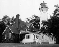
The Port Sanilac Light's foundation consists of dressed stone and timber. The octagon-hourglass-shaped tower (near its top) is made of tiered and reverse stair-stepped brick. It is 14 feet (4.3 m) in diameter at its base, and tapers vertically to 9 feet (2.7 m) diameter below the gallery. Eschewing the usual corbels, a dozen courses of bricks create the gallery support, with four indentations for windows, creating a watch room for the four points of the compass. [12] The lighthouse was built at a cost of $20,000. [15] The placement and the unique shape were dictated by and created because of budgetary constraints (Congress appropriated only half the money requested). Designed by Eleventh District Engineer Captain Charles E. L. B. Davis, the design has been called "both unique and architecturally significant in its elegance." [12] The tower is white with a red roof. [1]

This "handsome" lighthouse shares its design with only one other, Ile Aux Galets, also known as Skilligallee Island Light, on Lake Michigan. [16]

The Port Sanilac Light tower is capped with a cast iron lantern room, [12] which still houses a fourth order Fresnel lens [14] manufactured by Barbier and Fenestre of Paris. The lens and its brass reflector on one segment (the reflector blocked the lens on the landward side) send the light out in a 300 degree arc across the lake. Its focal plane is 69 feet (21 m) shines a beam of light visible for up to 16 nautical miles (30 km; 18 mi) in all directions, thus closing most of the 30 miles (48 km)-gap mentioned above. The light sits atop high ground at the head of a small bay. [12] This is one of only 70 such Fresnel lenses that are still operational in the United States, sixteen of which are use on the Great Lakes of which eight are in Michigan. [17]

Port Sanilac Light Station — Lake St. is a registered site on the National Register of Historic Places, being added on August 19, 1984 as listed site #84001842. Name of Listing: PORT SANILAC LIGHT STATION (U.S. COAST GUARD/GREAT LAKES TR). [1]

The Port Sanilac Light complex currently consists of five historic structures. In addition to the light tower and ornate brick Lighthouse keeper's residence, [12] the brick oil house, [18] wooden outhouse, and well also survive. The well is covered by a safety platform of wooden planks. [15] [19]

Because of its unique and picturesque form and location, it is often the subject of photographs, and even of needlepoint illustrations. [20] Drawings have also been produced, [21] as have postcards. [1]

The original fourth order Fresnel lens is still operative, being one of only 70 such lenses that remain operational in the United States; sixteen of them are use on the Great Lakes, of which eight are in Michigan. [6]

The lighthouse, including the keeper's house, is for sale. [22] [23] [24] [25]

Getting there

The lighthouse is private property; access around it is prohibited. Viewing from the parking lot is very good. You can also walk down toward the beach and breakwater to get a good view of the lighthouse and harbor.

From M-25.svg M-25 in Port Sanilac, Michigan, turn east onto Cherry Street, taking it to the Lake Huron shore. Public parking is at the terminus of Cherry Street, directly south of the light. The breakwater "is a nice place from which the lighthouse can be photographed." [26] [27]

See also

Related Research Articles

<span class="mw-page-title-main">Michigan Island Light</span> Lighthouse

The Michigan Island Lighthouse is a lighthouse operated by the National Park Service and located on Michigan Island on western Lake Superior in the Apostle Islands National Lakeshore.

<span class="mw-page-title-main">Gravelly Shoal Light</span> Lighthouse in Michigan, United States

Gravelly Shoals Light is an automated lighthouse that is an active aid to navigation on the shallow shoals extending southeast from Point Lookout on the western side of Saginaw Bay. The light is situated about 2.7 miles (4.3 km) offshore and was built to help guide boats through the deeper water between the southeast end of Gravelly Shoals and Charity Island. Architecturally this is considered to be Art Deco style.

<span class="mw-page-title-main">Ile Aux Galets Light</span> Lighthouse in Michigan, United States

Ile Aux Galets Light, also known as Skillagalee Island Light, is located on Ile Aux Galets, a gravelly, low-lying island in northeast Lake Michigan, between Beaver Island and the mainland, approximately 7 miles (11 km) northwest of Cross Village in Emmet County, Michigan. Along with nearby Grays Reef, Waugoshance, and White Shoal Lights, it warns shipping away from the reefs and shoals of Waugoshance Point, which pose an imminent hazard to navigation.

<span class="mw-page-title-main">DeTour Reef Light</span> Lighthouse in Michigan, United States

The DeTour Reef Light is a non-profit-operated lighthouse marking the southern entrance of the DeTour Passage between the eastern end of Michigan's Upper Peninsula and Drummond Island. The light is an automated active aid to navigation. It marks the northern end of Lake Huron. The passage is used by almost all of the Great Lakes commercial freighter traffic moving to and from Lake Superior, with approximately 5,000 vessel movements annually. It is said to be "the gateway to Lake Superior." In addition, many recreational boaters use the passage. The Light is located in Lake Huron, three miles (5 km) south of the nearest town, DeTour Village, Michigan.

<span class="mw-page-title-main">Alpena Light</span> Lighthouse in Michigan, United States

The Alpena Light, also known as the Thunder Bay River Lighthouse or Alpena Breakwater Light, is a lighthouse on Lake Huron near Alpena, Michigan. Standing on the north breakwater of Alpena Harbor, the light marks the entrance to the Thunder Bay River from Thunder Bay. The current lighthouse, built in 1914, replaced earlier wooden structures which had been in use since 1877 and 1888. The current light is a weather-protected structure on a steel frame. It was added to the National Register of Historic Places in 2006, and the state inventory list the same year.

<span class="mw-page-title-main">Charity Island Light</span> Lighthouse in Michigan, United States

Charity Island Light is a lighthouse on Big Charity Island in Lake Huron just off the coast of Au Gres, Northern Michigan.

<span class="mw-page-title-main">Fort Gratiot Light</span> Lighthouse in Michigan, United States

Fort Gratiot Light, the first lighthouse in the state of Michigan, was constructed north of Fort Gratiot in 1825 by Lucius Lyon, who later became one of Michigan's first U.S. Senators.

<span class="mw-page-title-main">Forty Mile Point Light</span> Lighthouse in Michigan, United States

Forty Mile Point Light is a lighthouse in Presque Isle County near Hammond Bay on the western shore of Lake Huron in Rogers Township, Michigan USA.

<span class="mw-page-title-main">Saginaw River Rear Range Light</span> Lighthouse in Michigan, United States

The first Saginaw River lighthouse was constructed from 1839 to 1841, in a period when large quantities of lumber were being harvested and shipped from the heart of Michigan via river and the Great Lakes to the East Coast of the United States via the Erie Canal and Hudson River. This connection to major eastern markets was critical to the development of central Michigan.

<span class="mw-page-title-main">Port Austin Light</span> Lighthouse in Michigan, United States

Port Austin Lighthouse is a lighthouse off the shore of Lake Huron, about 2.5 miles (4.0 km) north of Port Austin, Huron County Michigan sitting on a rocky reef (shoal), which is just north of the tip of the Thumb and a real hazard to navigation.

<span class="mw-page-title-main">Sturgeon Point Light</span> Lighthouse in Michigan, United States

The Sturgeon Point Light Station is a lighthouse on Lake Huron in Haynes Township, Alcona County, northeastern lower Michigan. Established to ward mariners off a reef that extends 1.5 miles (2.4 km) lakeward from Sturgeon Point, it is today regarded as a historic example of a Cape Cod style Great Lakes lighthouse.

<span class="mw-page-title-main">Chicago Harbor Light</span> Lighthouse

The Chicago Harbor Lighthouse is an automated active lighthouse, and stands at the south end of the northern breakwater protecting the Chicago Harbor, to the east of Navy Pier and the mouth of the Chicago River.

<span class="mw-page-title-main">Little Sable Point Light</span> Lighthouse in Michigan, United States

The Little Sable Point Light is a lighthouse located south of Pentwater in the lower peninsula of the U.S. state of Michigan. It is in the southwest corner of Golden Township, just south of Silver Lake State Park.

<span class="mw-page-title-main">Harbor Beach Light</span> Lighthouse in Michigan, United States

The Harbor Beach Lighthouse is a "sparkplug lighthouse" located at the end of the north breakwall entrance to the harbor of refuge on Lake Huron. The breakwall and light were created by the United States Army Corps of Engineers to protect the harbor of Harbor Beach, Michigan, which is the largest man-made freshwater harbor in the world. Harbor Beach is located on the eastern edge of the Thumb of Huron County, in the state of Michigan.

<span class="mw-page-title-main">Marquette Harbor Light</span> Lighthouse in Michigan, United States

The Marquette Harbor Light is located on Lake Superior in Marquette, Michigan, a part of the Upper Peninsula. It is an active aid to navigation.

<span class="mw-page-title-main">Fourteen Foot Shoal Light</span> Lighthouse in Michigan, United States

The lighthouse at Fourteen Foot Shoal was named to note that the lake is only 14 feet (4.3 m) deep at this point, which is a hazard to navigation, ships and mariners.

<span class="mw-page-title-main">Seul Choix Light</span> Lighthouse in Michigan, United States

The Seul Choix Light is a lighthouse located in the northwest corner of Lake Michigan in Schoolcraft County, Michigan. The station was established in 1892 with a temporary light, and this light started service in 1895, and was fully automated in 1972. It is an active aid to navigation. There is now a museum at the light and both the building and the grounds are open for visitors from Memorial Day until the middle of October.

<span class="mw-page-title-main">Sand Point Light</span> Lighthouse in Michigan, United States

The Sand Point Lighthouse is located in Escanaba, Michigan, United States, on Lake Michigan's northern shore. Since 1989, it has been an unofficial aid to navigation. Though it is an operational aid to navigation. The restored lighthouse is now open to the public during the summer months. It is also known as the Escanaba/Sand Point Light or the Escanaba Light.

<span class="mw-page-title-main">Gull Rock Light Station</span> Lighthouse in Michigan, United States

The Gull Rock Light Station is an active lighthouse located on Gull Rock, just west of Manitou Island, off the tip of Michigan's Keweenaw Peninsula in Lake Superior. The light was listed on the National Register of Historic Places in 1984, even as its condition deteriorated, resulting in its placement on the Lighthouse Digest Doomsday List.

<span class="mw-page-title-main">Huron Island Light</span> Lighthouse in Michigan, United States

Huron Island Light is a lighthouse on Lake Superior near Big Bay, Michigan. It was listed on the National Register of Historic Places as Huron Islands Lighthouse in 1975. It is on one of the Huron Islands WildernessArchived 2011-06-11 at the Wayback Machine.

References

  1. 1 2 3 4 Michigan Lighthouse Conservancy, Port Sanilac Lighthouse.
  2. Pepper, Terry. "Database of Tower Heights". Seeing the Light. terrypepper.com. Archived from the original on 2000-09-18. Retrieved 2009-09-16.
  3. Close up photograph of the hourglass stair-step brickwork at Terry Pepper, Seeing the Light.
  4. 1 2 "Michigan Lighthouse Fund, Port Sanilac". Archived from the original on 2009-01-06. Retrieved 2008-02-22.
  5. Pepper, Terry. "Database of Focal Heights". Seeing the Light. terrypepper.com. Archived from the original on 2008-08-30. Retrieved 2008-06-03.
  6. 1 2 United States Coast Guard, Fresnel Lenses Still in Operation Archived 2009-03-25 at Archive-It .
  7. Light List, Volume VII, Great Lakes (PDF). Light List. United States Coast Guard.But see, 11 nautical miles; 21 kilometres (13 mi) at Seeing The Light – Port Sanilac Lighthouse
  8. Light List, Volume VII, Great Lakes (PDF). Light List. United States Coast Guard.
  9. "National Register Information System". National Register of Historic Places . National Park Service. March 13, 2009.
  10. Interactive map on Michigan lighthouses Detroit News.
  11. Port Sanilac Lighthouse Archived 2009-02-02 at the Wayback Machine , Pure Michigan.
  12. 1 2 3 4 5 6 Port Sanilac Lighthouse at Seeing the Light by Terry Pepper.
  13. Lighthouse Central, Port Sanilac Lighthouse Photographs, History and Directions, The Ultimate Guide to East Michigan Lighthouses by Jerry Roach (Publisher: Bugs Publishing LLC - July 2006). ISBN   0-9747977-1-5; ISBN   978-0-9747977-1-7.
  14. 1 2 "Historic Light Station Information and Photography: Michigan". United States Coast Guard Historian's Office. Archived from the original on 2017-05-01.
  15. 1 2 "Wobser, David, Boatnerd.com Port Sanilac Light". Archived from the original on 2009-06-04. Retrieved 2009-10-27.
  16. Rowlett, Russ. "Lighthouses of the United States: Michigan's Eastern Lower Peninsula". The Lighthouse Directory. University of North Carolina at Chapel Hill.
  17. United States Coast Guard, Fresnel Lenses Still in Operation Archived 2009-03-25 at Archive-It
  18. Photo of the 360 US gallons (1,400 L; 300 imp gal) oil house at Terry Pepper, Seeing the Light.
  19. National Park Service, Maritime History Project, Inventory of Lights, Port Sanilac light.
  20. Needlepoint of Port Sanilac Light. [ permanent dead link ]
  21. Mulgrew, Marilyn, Drawing of Port Sanilac Light. Archived 2007-08-28 at the Wayback Machine
  22. "Port Sanilac Lighthouse for sale". The Detroit News . December 15, 2013. Retrieved December 19, 2013. Photo gallery
  23. Fitzmorris, Ryan (December 18, 2013). "Iconic Port Sanilac Lighthouse can be yours for about $1 million". Detroit Free Press . Retrieved December 19, 2013. Photo gallery
  24. Weiss, Diane, photographer (December 18, 2013). "360 degree view of the Port Sanilac Lighthouse in Michigan" (Panoramic photo). Detroit Free Press. Retrieved December 19, 2013.{{cite news}}: CS1 maint: multiple names: authors list (link)
  25. Weiss, Diane, photographer (December 18, 2013). "360 degree view of the Port Sanilac Lighthouse in Michigan" (Panoramic photo). Detroit Free Press. Retrieved December 19, 2013.{{cite news}}: CS1 maint: multiple names: authors list (link) Same photo, pinned at Facebook
  26. Lighthouse Friends, Port Sanilac Lighthouse.
  27. U.S. Lighthouses, Port Sanilac Light.