Charlevoix South Pier Light Station

Last updated
Charlevoix South Pier Light Station
Charlevoix South Pier Light Station (July 2022).jpg
View of the lighthouse in July 2022
Charlevoix South Pier Light Station
LocationS pier at harbor entrance, 0.3 WNW of US 31 drawbridge, Charlevoix County, Michigan
Coordinates 45°19′13″N85°15′54″W / 45.32024°N 85.26491°W / 45.32024; -85.26491
Tower
Constructed1948
Foundationpier
Constructionsteel skeletal tower, upper 2/3 enclosed [1]
Height44 feet (13 m)
Shape Square pyramid tower, decagonal lantern [2]
Markingsred Daymark/black lantern [3]
HeritageNational Register of Historic Places listed place  OOjs UI icon edit-ltr-progressive.svg
Light
Focal height13 m (43 ft)  OOjs UI icon edit-ltr-progressive.svg
LensFifth order Fresnel Lens [4] (original), 12-inch (300 mm) Tideland Signal ML-300 acrylic lens (current)
Range10 nautical miles (19 km; 12 mi)
Characteristic Flashing Red 4s HORN: 1 blast ev 30s (3s bl). Operates from May 1 to Oct. 20. [5]
Charlevoix South Pierhead Light
Arealess than 1-acre (4,000 m2)
Built1948
ArchitectUS Coast Guard, Ninth District
MPS Light Stations of the United States MPS
NRHP reference No. 05000346 [6]
Added to NRHPApril 28, 2005

The Charlevoix South Pier Light Station is located on Lake Michigan at the entrance to Lake Charlevoix in Charlevoix County in the U.S. state of Michigan at the end of the south pier/breakwater of the channel leading to Round Lake in the city of Charlevoix.

Contents

History

Old Charlevoix Light (note Fog bell), U. S. Coast Guard Archive USCGCharlevoix.jpg
Old Charlevoix Light (note Fog bell), U. S. Coast Guard Archive

The first light in Charlevoix was located on the north pier. It was erected in 1884 in order to guide ships to the newly improved Pine River channel. A lifesaving station was built just north of the lighthouse in 1898 and an oil shed was built in 1890. [7] The first tower was 56 feet (17 m) tall, [8] with a 61 feet (19 m) focal height. [9]

The original structure survived for 63 years, but due to terminal deterioration the decision was made to replace it in 1947. [10] In 1948 the new steel structure was installed and the light was moved to its current location on the south pier where the lens and lantern from the old structure were transferred to the new one. The skeletal structure and general configuration of this light shares some design elements with the Alpena Light. [11] The South Pierhead light was originally painted Daymark red. [12]

In 1965, because the Pine River channel is near a congested area, the Coast Guard vacated the old U.S. Life-Saving Service Station (tearing down the shingled building), and relocated to the grounds of the old Lighthouse Supply Station.

In 1989, the present steel and concrete pier replaced the old wooden pier with its concrete covering. The present piers and revetments were constructed in the 1970s and 1980s. The construction is specially designed to withstand unusually forceful wave pressures, and to protect the harbor. As Terry Pepper wrote:

Constructed of driven steel piles with concrete and rock fill, wooden buffers were added where needed. These new piers were designed to incorporate hydrodynamic features to protect the harbor area. The rectangular gaps beyond the beach are intended to absorb and break-up inbound wave force, thereby reducing the swells that would travel from the big lake all the way up the channel into Round Lake. The Pine River Channel is believed to be unique in the entire world inasmuch as it has a two-way current. After severe westerly windstorms, waters pushed high into Lake Charlevoix will swiftly flow back out to meet other inbound currents. Small whirlpools and eddies at the harbor mouth are not uncommon, and whitecaps can frequently be observed within the channel on the calmest days.

Terry Pepper [13]

The skeletal north pierhead tower has since been removed. [12]

The lighthouse as it appeared in 1999 CharlevoixLight.jpg
The lighthouse as it appeared in 1999
Charlevoix Lights, north and south piers in 2005 Charlevoix Lighthouse.jpg
Charlevoix Lights, north and south piers in 2005

The 12-inch (300 mm) Tideland Signal ML-300 acrylic lens is described as a medium-range modern Great Lakes lens with a maximum range of 10 nautical miles (19 km; 12 mi). [5] [14]

The North Pierhead Light is at coordinates 45 19 18 N 85 15 54 W, and its characteristic is Flashing Green 2.5 seconds. The current tower is 20 feet (6.1 m) and it is an active aid to navigation. [5] The former North tower's height is 56 feet, with a focal plane of 61 feet. [15]

Described as the Charlevoix South Pierhead Light (added 2005 - Structure - #05000346) and also known as the Charlevoix Pier Light, it is listed in the National Register of Historic Places. [16] Specifically, it is described as "S pier at harbor entrance, 0.3 WNW of US 31 drawbridge, Charlevoix". Although it was unmanned, the National Park System has recognized it as a "significant aid to navigation." [17]

In 2009 the light was again painted red in keeping with the mariner's alliterative Mnemonic "Red Right returning." [3] For unknown reasons, previous Daymark color schemes have been green, white. [3] or originally red (until 1968). [1] [13] [18] See Sea mark.

A primary vessel benefiting from the Charlevoix Light is the Beaver Island ferry. [2]

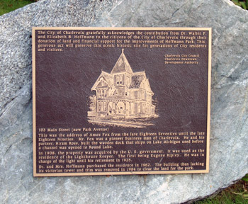
The land based lighthouse keeper's residence was sold to a private owner and demolished. The property became Hoffman Park, and all that remains is a metal plaque. [19]

In 2008, ownership of the light was transferred from the U.S. Coast Guard to the City of Charlevoix/Charlevoix Historical Society. The transfer was completed under the National Historic Lighthouse Preservation Act. [1] [12]

See also

Notes

  1. 1 2 3 Rowlett, Russ. "Lighthouses of the United States: Michigan's Western Lower Peninsula". The Lighthouse Directory. University of North Carolina at Chapel Hill.
  2. 1 2 Wobser, David, Charlevoix South Pier Light Station Archived 2009-07-25 at the Wayback Machine at boatnerd.com.
  3. 1 2 3 Lighthouses of Northern Lake Michigan at Archived 2009-09-14 at the Wayback Machine U.S. Lighthouses.
  4. Pepper, Terry. "Database of Original Lenses". Seeing the Light. terrypepper.com. Archived from the original on 2000-09-18. Retrieved 2009-12-15.
  5. 1 2 3 Light List, Volume VII, Great Lakes (PDF). Light List. United States Coast Guard.
  6. "National Register Information System". National Register of Historic Places . National Park Service. March 13, 2009.
  7. "Historic Light Station Information and Photography: Michigan". United States Coast Guard Historian's Office. Archived from the original on 2017-05-01.
  8. Pepper, Terry. "Database of Tower Heights". Seeing the Light. terrypepper.com. Archived from the original on 2000-09-18.
  9. Pepper, Terry. "Database of Focal Heights". Seeing the Light. terrypepper.com. Archived from the original on 2008-08-30.
  10. Lighthouse Central, Photographs, History, Directions and Way points for Charlevoix South Pier Light Station, The Ultimate Guide to West Michigan Lighthouses by Jerry Roach (Publisher: Bugs Publishing LLC - 2005). ISBN   0-9747977-0-7.
  11. Pepper, Terry. "Database of Tower Designs". Seeing the Light. terrypepper.com. Archived from the original on 2009-11-15.
  12. 1 2 3 Michigan Lighthouse Conservancy, Charlevoix South Pierhead Light.
  13. 1 2 Terry Pepper, Seeing the Light, Charlevoix Light Station.
  14. Tideland Signal lens, Terry Pepper, Seeing the Light.
  15. Pepper, Terry. "Seeing the Light: Lighthouses on the western Great Lakes". Archived from the original on 2008-01-30.
  16. National Register of Historical Places.
  17. National Park Service Maritime History Project, Inventory of Significant Unmanned Aids to Navigation, Charlevoix South Pier Light.
  18. Antique Postcard (ca. 1955), South Pier Light with original red paint from Terry Pepper, Seeing the Light.
  19. Anderson, Kraig, Lighthouse Friends, description Charlevoix South Pier Light.

Further reading

Related Research Articles

<span class="mw-page-title-main">Kenosha Light</span> Lighthouse

Kenosha Light is a lighthouse and keeper's house on Simmons Island north of the channel into Kenosha's harbor in Kenosha County, Wisconsin, USA.

<span class="mw-page-title-main">Kewaunee Pierhead Light</span> Lighthouse

The Kewaunee Pierhead lighthouse is a lighthouse located near Kewaunee in Kewaunee County, Wisconsin. The lighthouse looks nearly identical to the Holland Harbor Lighthouse, except that it is colored white.

<span class="mw-page-title-main">Big Sable Point Light</span> Lighthouse in Michigan, United States

The Big Sable Point Light is a lighthouse on the eastern shore of Lake Michigan near Ludington in Mason County, Michigan, at the Ludington State Park. It is an active aid to navigation.

<span class="mw-page-title-main">Alpena Light</span> Lighthouse in Michigan, United States

The Alpena Light, also known as the Thunder Bay River Lighthouse or Alpena Breakwater Light, is a lighthouse on Lake Huron near Alpena, Michigan. Standing on the north breakwater of Alpena Harbor, the light marks the entrance to the Thunder Bay River from Thunder Bay. The current lighthouse, built in 1914, replaced earlier wooden structures which had been in use since 1877 and 1888. The current light is a weather-protected structure on a steel frame. It was added to the National Register of Historic Places in 2006, and the state inventory list the same year.

<span class="mw-page-title-main">Saginaw River Rear Range Light</span> Lighthouse in Michigan, United States

The first Saginaw River lighthouse was constructed from 1839 to 1841, in a period when large quantities of lumber were being harvested and shipped from the heart of Michigan via river and the Great Lakes to the East Coast of the United States via the Erie Canal and Hudson River. This connection to major eastern markets was critical to the development of central Michigan.

<span class="mw-page-title-main">Port Austin Light</span> Lighthouse in Michigan, United States

Port Austin Lighthouse is a lighthouse off the shore of Lake Huron, about 2.5 miles (4.0 km) north of Port Austin, Huron County Michigan sitting on a rocky reef (shoal), which is just north of the tip of the Thumb and a real hazard to navigation.

<span class="mw-page-title-main">Chicago Harbor Light</span> Lighthouse

The Chicago Harbor Lighthouse is an automated active lighthouse, and stands at the south end of the northern breakwater protecting the Chicago Harbor, to the east of Navy Pier and the mouth of the Chicago River.

<span class="mw-page-title-main">Milwaukee Pierhead Light</span> Lighthouse

The Milwaukee Pierhead Light is an active lighthouse located in the Milwaukee harbor, just south of downtown. This aid to navigation is a 'sister' of the Kenosha North Pier Light.

<span class="mw-page-title-main">Milwaukee Breakwater Light</span> Lighthouse

The Milwaukee Breakwater lighthouse was built in 1926 in the harbor of Milwaukee in Milwaukee County, Wisconsin to mark the entrance to the harbor. One of the last fully enclosed breakwater lighthouses in the Great Lakes, the structure was placed on the National Register of Historic Places in 2011.

<span class="mw-page-title-main">Round Island Light, Michigan</span> Lighthouse in Michigan, United States

For the lighthouse of the same name in the St. Mary's River, see Round Island Light

<span class="mw-page-title-main">Little Sable Point Light</span> Lighthouse in Michigan, United States

The Little Sable Point Light is a lighthouse located south of Pentwater in the lower peninsula of the U.S. state of Michigan. It is in the southwest corner of Golden Township, just south of Silver Lake State Park.

<span class="mw-page-title-main">Manistee Pierhead lights</span> Lighthouses in Michigan, United States

The Manistee Pierhead lights are a pair of active aids to navigation located on the north and south pier in the harbor of Manistee, Michigan, "Lake Michigan’s Victorian Port City."

<span class="mw-page-title-main">Menominee Pier Light</span> Lighthouse in Michigan, United States

The Menominee North Pier lighthouse is located in the harbor of Menominee, Michigan. The station was first lit in 1877. The current structure and its still operational light was lit in 1927, and automated in 1972. It is also sometimes called the "Menominee (Marinette) North Pierhead Light".

<span class="mw-page-title-main">Michigan City East Light</span> Lighthouse

The Michigan City Breakwater lighthouse is located in the harbor of Michigan City, Indiana.

<span class="mw-page-title-main">Muskegon Pier Light</span> Lighthouse in Michigan, United States

The Muskegon South Pierhead Light or Muskegon Pier Light is a lighthouse located on the channel in the harbor of Muskegon, Michigan.

<span class="mw-page-title-main">Harbor Beach Light</span> Lighthouse in Michigan, United States

The Harbor Beach Lighthouse is a "sparkplug lighthouse" located at the end of the north breakwall entrance to the harbor of refuge on Lake Huron. The breakwall and light were created by the United States Army Corps of Engineers to protect the harbor of Harbor Beach, Michigan, which is the largest man-made freshwater harbor in the world. Harbor Beach is located on the eastern edge of the Thumb of Huron County, in the state of Michigan.

<span class="mw-page-title-main">Port Sanilac Light</span> Lighthouse in Michigan, United States

Port Sanilac Light is a United States Coast Guard lighthouse located on Point Sanilac, near Port Sanilac on the eastern side of Michigan's Thumb. It is an automated and active aid to navigation on Lake Huron.

<span class="mw-page-title-main">Sand Point Light</span> Lighthouse in Michigan, United States

The Sand Point Lighthouse is located in Escanaba, Michigan, United States, on Lake Michigan's northern shore. Since 1989, it has been an unofficial aid to navigation. Though it is an operational aid to navigation. The restored lighthouse is now open to the public during the summer months. It is also known as the Escanaba/Sand Point Light or the Escanaba Light.

<span class="mw-page-title-main">Grand Island Harbor Rear Range Light</span> Lighthouse in Michigan, United States

The Grand Island Harbor Rear Range Light is a lighthouse located off M-28 in Munising Township, Michigan. It is also known as the Bay Furnace Rear Range Light, Christmas Rear Range Light, or End of the Road Light. The corresponding front range light was replaced in 1968; the rear range light was listed on the National Register of Historic Places in 1990. It is no longer an active aid to navigation.

<span class="mw-page-title-main">Navigation Structures at Pentwater Harbor</span> Navigation structures in Michigan, United States

The Navigation Structures at Pentwater Harbor are navigational structures located at the west end of Lowell Street in Pentwater, Michigan. They were listed on the National Register of Historic Places in 2001.