Location | Beaver Island St. James, Michigan United States |
---|---|
Coordinates | 45°44′34″N85°30′31″W / 45.74278°N 85.50861°W Coordinates: 45°44′34″N85°30′31″W / 45.74278°N 85.50861°W |
Tower | |
Constructed | 1856 (original tower) 1870 (current tower) |
Automated | 1927 |
Height | 41 feet (12 m) |
Shape | Cylindrical |
Markings | White (Originally yellow) w/ black lantern |
Light | |
First lit | 1870 |
Focal height | 38 feet (12 m) [1] |
Lens | Fourth Order Fresnel |
Range | 10 nautical miles (19 km; 12 mi) |
Characteristic | ISO Red 6 seconds Light obscured from 127°30′ to 199°30 [2] |
Beaver Island Light Station | |
Nearest city | St. James, Michigan |
Area | 64.2 acres (26.0 ha) |
NRHP reference No. | 78001495 [3] |
Added to NRHP | December 29, 1978 |
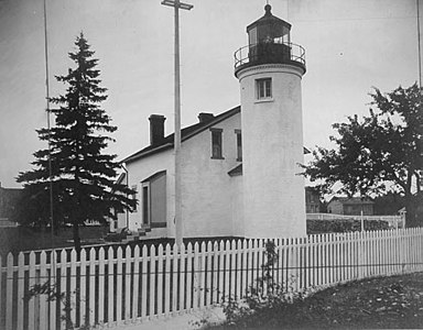
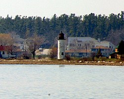
Beaver Island Harbor Light (or St. James Light) is a lighthouse located in St. James, Michigan, on the northern end of Beaver Island on Lake Michigan. [4] It has also been called "St. James Harbor Light" and "Whiskey Point Light". It is associated with a U.S. Coast Guard station, which was formerly a lifesaving station. [5] The tower is constructed of Cream City Brick.
Whiskey Point was originally named for the 1838 fur trading post that operated on the point, and for the commodity that was the post's chief item of sale. Soon afterward in the 1850s, St. James's Harbor on Beaver Island became established as a safe haven in a storm (an event quite common on Lake Michigan). The light was thus a natural extension of the emergency usage. The original light was constructed in 1856, and the light currently in use was constructed in 1870. [6]
At this time, the harbor is used by the Beaver Island ferry, so the light is still an active aid to navigation.
The Frankfort Light is a lighthouse located on the north breakwater in the harbor in Frankfort, Michigan. The current light was constructed in 1912 and placed on the National Register of Historic Places in 2005.
The Charlevoix South Pier Light Station is located on Lake Michigan at the entrance to Lake Charlevoix in Charlevoix County in the U.S. state of Michigan at the end of the south pier/breakwater of the channel leading to Round Lake in the city of Charlevoix.
The Michigan Island Lighthouse is a lighthouse operated by the National Park Service and located on Michigan Island on western Lake Superior in the Apostle Islands National Lakeshore.
The buildings of the St Helena Light complex are the sole surviving structures on St. Helena Island, in Mackinac County in the U.S. state of Michigan. The lighthouse on the St. Helena Island's southeastern point was built in 1872-1873 and went into operation in September 1873. It became one of a series of lighthouses that guided vessels through the Straits of Mackinac, past a dangerous shoal that extends from the island.
The Ashland Harbor Breakwater lighthouse, also known as Ashland Breakwater Lighthouse, is an operational lighthouse located near Ashland in Ashland County, Wisconsin, USA. Located in Chequamegon Bay of Lake Superior, it is owned and managed by the National Park Service, and is a part of the Apostle Islands National Lakeshore. It sits at the end of a long and detached breakwater, which creates an artificial harbor.
Kenosha Light is a lighthouse and keeper's house on Simmons Island north of the channel into Kenosha's harbor in Kenosha County, Wisconsin, USA.
The Whitefish Point Light is a lighthouse located in Chippewa County in the U.S. state of Michigan. Located on the southeastern shores of Lake Superior, it sits at the edge of Whitefish Point leading to Whitefish Bay. Constructed in 1849, it is the oldest operating lighthouse in the Upper Peninsula. All vessels entering or exiting Lake Superior pass near Whitefish Point. The area is infamously known as the "Graveyard of the Great Lakes" due to the high number of shipwrecks in the area, most famously the SS Edmund Fitzgerald.
Fort Gratiot Light, the first lighthouse in the state of Michigan, was constructed north of Fort Gratiot in 1829 by Lucius Lyon, who later became one of Michigan's first U.S. Senators.
The Beaver Head Light is located high on a bluff on the southern tip of Beaver Island. Boats trying to navigate North on Lake Michigan need to carefully work their way between Beaver Island and Gray's Reef.
The Sturgeon Point Light Station is a lighthouse on Lake Huron in Haynes Township, Alcona County, northeastern lower Michigan. Established to ward mariners off a reef that extends 1.5 miles (2.4 km) lakeward from Sturgeon Point, it is today regarded as a historic example of a Cape Cod style Great Lakes lighthouse.
For the lighthouse of the same name in the St. Mary's River, see Round Island Light
The Manistee Pierhead lights are a pair of active aids to navigation located on the north and south pier in the harbor of Manistee, Michigan, "Lake Michigan’s Victorian Port City."
Tawas Point Light is located in the Tawas Point State Park off Tawas Bay in Lake Huron in Baldwin Township in Northern Michigan.
The Marquette Harbor Light is located on Lake Superior in Marquette, Michigan, a part of the Upper Peninsula. It is an active aid to navigation.
The ruined lighthouse at Waugoshance protects boats from a shoal area at the northern end of Lake Michigan. The lighthouse is located in Emmet County, Michigan, United States, and in U.S. Coast Guard District No. 9. It is approximately 15 miles (24 km) west of Mackinaw City. Due to erosion and deterioration, the lighthouse is deteriorating and critically endangered, and likely to fall into the lake in the near future.
The Seul Choix Light is a lighthouse located in the northwest corner of Lake Michigan in Schoolcraft County, Michigan. The station was established in 1892 with a temporary light, and this light started service in 1895, and was fully automated in 1972. It is an active aid to navigation. There is now a museum at the light and both the building and the grounds are open for visitors from Memorial Day until the middle of October.
The Rock of Ages Light is a U.S. Coast Guard lighthouse on a small rock outcropping approximately 2.25 miles (3.62 km) west of Washington Island and 3.5 miles (5.6 km) west of Isle Royale, in Eagle Harbor Township, Keweenaw County, Michigan. It is an active aid to navigation.
Round Island Passage Light is an automated, unmanned lighthouse located in the Round Island Channel in the Straits of Mackinac, Michigan. The channel is a branch of Lake Huron.
Buffalo North Breakwater South End Light is a lighthouse formerly located at the entrance to Buffalo Harbor, Buffalo, New York. It is one of two "bottle shaped" beacons located in Buffalo Harbor; the other is the South Buffalo North Side Light. It is a 29-foot (8.8 m) high beacon constructed of boiler plate. It measures 10 feet 3⁄4 inch (3.067 m) at the bottom and 2 feet 3 inches (0.69 m) at the top. It is distinguished by four cast iron port windows and a curved iron door. It was first lit on September 1, 1903, and originally equipped with a 6th-order Fresnel lens. A battery operated 12 volt lamp with a 12 inches (300 mm) green plastic lens was installed in the beacon c. 1960, when a domed roof formerly mounted over the lens was removed. The beacon was removed in 1985, and now stands on the grounds of the Buffalo (main) Light. Its twin is located at the Dunkirk Lighthouse and Veterans Park Museum.
The Detroit River Light, also known as Bar Point Shoal Light, was first established as a lightship in 1875. The current sparkplug lighthouse was built in 1885. It sits in Lake Erie, south of the mouth of the Detroit River, 1.75 nautical miles from land and about 20 nautical miles from the Ambassador Bridge in the Detroit River. It is about 0.4 nautical miles from the border with Canada, and just under 24 nautical miles from Put-in-Bay, Ohio. Its original 4th order Fresnel lens is on loan to the Michigan Maritime Museum.