St. James, Michigan

Last updated

St. James, Michigan
Whiskey Point.jpg
St. James, MI location.png
Location within Charlevoix County
USA Michigan location map.svg
Red pog.svg
St. James
Location within the state of Michigan
Usa edcp location map.svg
Red pog.svg
St. James
Location within the United States
Coordinates: 45°44′47″N85°31′18″W / 45.74639°N 85.52167°W / 45.74639; -85.52167
CountryUnited States
State Michigan
County Charlevoix
Township St. James
Area
[1]
  Total1.03 sq mi (2.67 km2)
  Land1.03 sq mi (2.67 km2)
  Water0.00 sq mi (0.01 km2)
Elevation
[2]
604 ft (184 m)
Population
 (2020)
  Total145
  Density140.91/sq mi (54.41/km2)
Time zone UTC-5 (Eastern (EST))
  Summer (DST) UTC-4 (EDT)
ZIP code(s)
Area code 231
FIPS code 26-70900
GNIS feature ID0636683 [2]

St. James is an unincorporated community and census-designated place (CDP) in Charlevoix County in the U.S. state of Michigan. [2] The population of the CDP was 145 at the 2020 census. [3] The community is located within St. James Township.

Contents

Located on the northern coast of Beaver Island in Lake Michigan, St. James was the county seat of Manitou County during the county's existence from 1855 to 1895.

History

The community was settled as early as 1847 when James Jesse Strang took over his Mormon church and settled his colony on Beaver Island. Originally part of Michilimackinac County, it received a post office named Beaver Island on January 13, 1849 with Charles Wright serving as the first postmaster. Strang named the new community after himself, and the post office was renamed St. James on October 10, 1854 when it became part of Emmet County. Strang declared himself to be a king—the only king ever crowned in the United States. After Strang's murder in 1856 by disgruntled followers, the community began to fold, and the post office closed on March 6, 1868. Charles Wright restored the post office under the name Beaver Island on December 19, 1868 and served again as postmaster. During the 1870s, St. James was also referred as Beaver Harbor. By 1895, the Mormons left the island, and St. James became part of Charlevoix County. It is now a resort community. [4]

The community of St. James was listed as a newly-organized census-designated place for the 2010 census, meaning it now has officially defined boundaries and population statistics for the first time. [5]

Geography

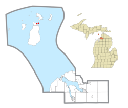
According to the U.S. Census Bureau, the St. James CDP has a total area of 1.03 square miles (2.67 km2), all land.

St. James is located in St. James Township at the northern end of Beaver Island, the largest island in Lake Michigan. The center of town faces southeast onto St. James Harbor, through which the Beaver Island Ferry arrives from Charlevoix. The northeastern side of the entrance to the harbor is marked by the Beaver Island Harbor Light. The St. James CDP extends east about 0.5 miles (0.8 km) to Lookout Point and Sucker Point, marking the northeastern end of the island.

Demographics

Historical population
CensusPop.Note
2010 205
2020 145−29.3%
U.S. Decennial Census [6]

Education

St. James is served entirely by Beaver Island Community School. [7] The Beaver Island Community School is located within St. James and serves the entire district. It is one of only four insular school districts in the state, along with Bois Blanc Pines School District, Grosse Ile Township Schools, and Mackinac Island School District.

Related Research Articles

<span class="mw-page-title-main">Emmet County, Michigan</span> County in Michigan, United States

Emmet County is a county located in the U.S. state of Michigan. It is the northernmost county in the Lower Peninsula. As of the 2020 Census, the population was 34,112, making it the second-most populous county in Northern Michigan. The county seat is Petoskey, which is also the county's largest city.

<span class="mw-page-title-main">Charlevoix County, Michigan</span> County in Michigan, United States

Charlevoix County is a county in the U.S. state of Michigan. The county seat is Charlevoix. Located in the Northern Lower Peninsula, Charlevoix County is bisected by Lake Charlevoix, Michigan's third largest inland lake. As of the 2020 Census, the county's population was 26,054.

<span class="mw-page-title-main">Chandler Township, Charlevoix County, Michigan</span> Civil township in Michigan, United States

Chandler Township is a civil township of Charlevoix County in the U.S. state of Michigan. The population was 248 at the 2010 census.

<span class="mw-page-title-main">Charlevoix, Michigan</span> City in Michigan, United States

Charlevoix is a city in the U.S. state of Michigan. It is the county seat of Charlevoix County. Part of Northern Michigan, Charlevoix is located on an isthmus between Lake Michigan and Lake Charlevoix, bisected by the short Pine River. Charlevoix serves as the main access point for Beaver Island, the largest island in Lake Michigan, which can be accessed by Island Airways or carferry. The population of Charlevoix was 2,348 at the 2020 census. Charlevoix is mostly surrounded by Charlevoix Township, but the two are administered autonomously.

<span class="mw-page-title-main">Eveline Township, Michigan</span> Civil township in Michigan, United States

Eveline Township is a civil township of Charlevoix County in the U.S. state of Michigan. The population was 1,484 at the 2010 census.

<span class="mw-page-title-main">Hayes Township, Charlevoix County, Michigan</span> Civil township in Michigan, United States

Hayes Township is a civil township of Charlevoix County in the U.S. state of Michigan. The population was 1,919 at the 2010 census.

<span class="mw-page-title-main">Hudson Township, Charlevoix County, Michigan</span> Civil township in Michigan, United States

Hudson Township is a civil township of Charlevoix County in the U.S. state of Michigan. The population was 691 at the 2010 census.

<span class="mw-page-title-main">Marion Township, Charlevoix County, Michigan</span> Civil township in Michigan, United States

Marion Township is a civil township of Charlevoix County in the U.S. state of Michigan. The population was 1,714 at the 2010 census.

<span class="mw-page-title-main">Peaine Township, Michigan</span> Civil township in Michigan, United States

Peaine Township is a civil township of Charlevoix County in the U.S. state of Michigan. The population was 292 at the 2010 census.

<span class="mw-page-title-main">South Arm Township, Michigan</span> Civil township in Michigan, United States

South Arm Township is a civil township of Charlevoix County in the U.S. state of Michigan. The population was 1,873 at the 2010 census.

<span class="mw-page-title-main">St. James Township, Michigan</span> Civil township in Michigan, United States

St. James Township is a civil township of Charlevoix County in the U.S. state of Michigan. The population was 365 at the 2010 census.

<span class="mw-page-title-main">Beaver Island (Lake Michigan)</span> Island in Charlevoix County, Michigan, USA

Beaver Island is an island in Lake Michigan in the U.S. state of Michigan. At 55.8 sq mi (145 km2), it is the largest island in Lake Michigan and the third largest island in Michigan after Isle Royale and Drummond Island. The island is located approximately 32 miles (51 km) from the city of Charlevoix. Beaver Island had a total population of 657 at the 2010 census. Beaver Island is part of Charlevoix County.

<span class="mw-page-title-main">Bay Shore, Michigan</span> Census-designated place & unincorporated community in Michigan, United States

Bay Shore is an unincorporated community and census-designated place (CDP) located on the boundary between Charlevoix County and Emmet County in the U.S. state of Michigan. The population of the CDP was 657 at the 2020 census.

<span class="mw-page-title-main">Ironton, Michigan</span> Census-designated place & unincorporated community in Michigan, United States

Ironton is an unincorporated community and census-designated place (CDP) in Charlevoix County in the U.S. state of Michigan. The population of the CDP was 148 at the 2020 census. It is located within Eveline Township on a narrow portion of Lake Charlevoix that is traversed by the Ironton Ferry.

<span class="mw-page-title-main">Manitou County, Michigan</span> Former county in Michigan

Manitou County was an insular county in the U.S. state of Michigan, consisting of Beaver Island and its surrounding islands, together with the North and South Manitou Islands and Fox Islands in Lake Michigan. The county existed from 1855 to 1895. The county seat was at St. James on Beaver Island.

<span class="mw-page-title-main">Norwood, Michigan</span> Census-designated place & unincorporated community in Michigan, United States

Norwood is an unincorporated community and census-designated place (CDP) in Charlevoix County in the U.S. state of Michigan. The population of the CDP was 144 at the 2020 census. It is located along the shores of Lake Michigan in Norwood Township.

<span class="mw-page-title-main">Walloon Lake, Michigan</span> Census-designated place & unincorporated community in Michigan, United States

Walloon Lake is an unincorporated community and census-designated place (CDP) in Charlevoix County in the U.S. state of Michigan. The population of the CDP was 271 at the 2020 census. The community is located within Melrose Township.

<span class="mw-page-title-main">Advance, Michigan</span> Census-designated place & unincorporated community in Michigan, United States

Advance is an unincorporated community and census-designated place (CDP) in Charlevoix County in the U.S. state of Michigan. The population of the CDP was 340 at the 2020 census. The community is located along Lake Charlevoix within Eveline Township.

<span class="mw-page-title-main">Horton Bay, Michigan</span> Census-designated place & unincorporated community in Michigan, United States

Horton Bay is an unincorporated community and census-designated place (CDP) in Charlevoix County in the U.S. state of Michigan. The population of the CDP was 485 at the 2020 census. The community is located within Bay Township on northeastern shores of Lake Charlevoix.

References

  1. "2020 U.S. Gazetteer Files". United States Census Bureau. Retrieved May 21, 2022.
  2. 1 2 3 U.S. Geological Survey Geographic Names Information System: St. James, Michigan
  3. "Geographic Identifiers: 2010 Demographic Profile Data (G001): St. James CDP, Michigan". U.S. Census Bureau, American Factfinder. Archived from the original on February 12, 2020. Retrieved July 1, 2022.
  4. Romig, Walter (October 1, 1986) [1973]. Michigan Place Names: The History of the Founding and the Naming of More Than Five Thousand Past and Present Michigan Communities. Great Lakes Books Series (Paperback). Detroit, Michigan: Wayne State University Press. p. 494. ISBN   978-0-8143-1838-6.
  5. "Michigan: 2010 Population and Housing Unit Counts 2010 Census of Population and Housing" (PDF). 2010 United States Census . United States Census Bureau. September 2012. p. III-4. Retrieved February 29, 2020.
  6. "Census of Population and Housing". Census.gov. Retrieved June 4, 2016.
  7. Michigan Geographic Framework (November 15, 2013). "Charlevoix County School Districts" (PDF). Retrieved August 6, 2022.