Cheboygan Crib Light

Last updated
Cheboygan Crib Light
CheboyganCrib.jpg
The light in 2001
Cheboygan Crib Light
Location Cheboygan, Michigan
Coordinates 45°39.408′N84°27.900′W / 45.656800°N 84.465000°W / 45.656800; -84.465000
Tower
Constructed1884
Foundationoak ring
Constructioncast iron
Height25 feet (7.6 m) [1]
Shape Octagonal and frustum of a cone
MarkingsWhite tower with red lantern and trim
Light
First lit1884
Deactivated1984  OOjs UI icon edit-ltr-progressive.svg
Focal height35 feet (11 m) [2]
LensFourth-order Fresnel lens [3]
Range10 nautical miles (19 km; 12 mi)
Characteristic Fl Red, 4 seconds [4]

The Cheboygan Crib Light is a light that marks the west pier head of the mouth of the Cheboygan River into Lake Huron. [5] [6] The pier head, in the center of the municipality of Cheboygan, is located at the north or lake end of Huron Street, and is one of the centerpieces of Cheboygan's Gordon Turner Park. [7]

Contents

History

1884-1920: manned light

The Crib Light is called a "light" rather than a "lighthouse" because it does not contain a structure in which a keeper lived. The Light was originally built in Lake Huron in 1884 on a "crib", an artificial-island landfill, [8] more than 2,000 feet (610 m) from the Cheboygan shore. It is assumed that the keeper lived in Cheboygan; this would have required him to boat daily to the crib, despite weather conditions, to maintain the kerosene-fired light. This was hazardous duty, and in due course davits were installed on the Crib Light; this enabled a boat making dock at the crib to be raised, more easily unloaded, and be protected from the waves. [9]

In 1901 this station was painted white to increase its visibility as a daymark. Two years later, in 1903, the existing wooden structure was torn down to a depth of 12 inches (300 mm) into the water and a new sturdier concrete steel structure was erected. Iron railings were also installed to aid with safety.[ citation needed ]

In 1906, the rebuilt light was severely damaged when a schooner hit it. A fog bell was then installed to help prevent such collisions and the railing was replaced. In 1911 an automated fog bell was installed, sounding a characteristic single stroke every ten seconds. [9]

1920-present: automated light

In 1920, the Lighthouse Service oversaw the automation of the Crib Light. In the Crib Light's new incarnation, kerosene was no longer necessary; instead, a traveling crew periodically delivered tanks of the flammable gas acetylene. A reliable pilot light burned day and night. When the sun set, the resulting drop in temperature would open a precision valve and release a flow of acetylene against the pilot light, causing the light to shine.

When last Lighthouse keeper left in 1929, it quickly degraded. "The light earned the nickname 'The Dummy'” from the locals." [10]

In the second half of the 20th century, the invention of radar and other electronic aids to navigation began to render many Great Lakes navigational light towers redundant. The Crib Light was considered by the Coast Guard to be "surplus" property. In 1984, the Crib Light tower was removed from its crib and placed on its current base located on the Gordon Turner Park pier head. [9] [11] [12]

As noted by a Coast Guard researcher:

The light earned the nickname “The Dummy” from the locals. When locals learned of the Coast Guard’s plans to demolish the site, an agreement was made to donate the light to the city of Cheboygan. The light was moved to the West Breakwall in the Gordon Turner Park. Restoration work has been done on the tower. The grounds are open to the public. [13]

The Cheboygan Crib Light is now maintained by the municipality of Cheboygan; the light itself, which is now powered by electricity, is maintained by a local support group. The light tower is considered by many to be a symbol of Cheboygan. In 2003, the municipality succeeded in clearing its title to the light and erasing its status as "surplus" property nominally under the ownership of the federal General Services Administration. [14]

Location

The light is in Gordon Turner Park, which is located north of U.S. Highway 23 in Cheboygan, just west of the Cheboygan River. The park is at the end of Huron Street for less than 1 mile (1.6 km) north of the highway. The park's boardwalk leads to the Cheboygan River and the light. The light may also been viewed from eastbound lighthouse cruises offered by Shepler's Ferry out of Mackinaw City. [15] [16]

It is not lighted at this time. Visitors to Gordon Turner Park can view and walk around the light at the end of Water Street in Cheboygan. [15] A few blocks upriver is the Cheboygan River Front Range Light. [13]

Related Research Articles

<span class="mw-page-title-main">Charlevoix South Pier Light Station</span> Lighthouse in Michigan, United States

The Charlevoix South Pier Light Station is located on Lake Michigan at the entrance to Lake Charlevoix in Charlevoix County in the U.S. state of Michigan at the end of the south pier/breakwater of the channel leading to Round Lake in the city of Charlevoix.

<span class="mw-page-title-main">Granite Island Lighthouse</span> Lighthouse in Michigan, United States

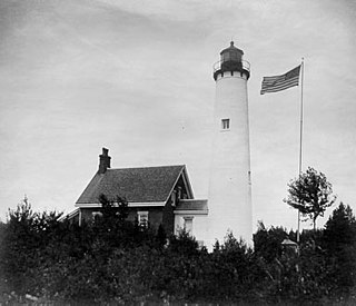
Because it was positioned near the busy shipping lanes of the mid-19th century, a lighthouse was built on Granite Island in 1868 by the U.S. Lighthouse Board and commissioned in 1869.

<span class="mw-page-title-main">St. Helena Island Light</span> Lighthouse in Michigan, United States

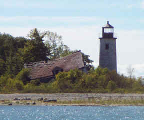
The buildings of the St Helena Light complex are the sole surviving structures on St. Helena Island, in Mackinac County in the U.S. state of Michigan. The lighthouse on the St. Helena Island's southeastern point was built in 1872-1873 and went into operation in September 1873. It became one of a series of lighthouses that guided vessels through the Straits of Mackinac, past a dangerous shoal that extends from the island.

<span class="mw-page-title-main">Gravelly Shoal Light</span> Lighthouse in Michigan, United States

Gravelly Shoals Light is an automated lighthouse that is an active aid to navigation on the shallow shoals extending southeast from Point Lookout on the western side of Saginaw Bay. The light is situated about 2.7 miles (4.3 km) offshore and was built to help guide boats through the deeper water between the southeast end of Gravelly Shoals and Charity Island. Architecturally this is considered to be Art Deco style.

<span class="mw-page-title-main">Charity Island Light</span> Lighthouse in Michigan, United States

Charity Island Light is a lighthouse on Big Charity Island in Lake Huron just off the coast of Au Gres, Northern Michigan.

<span class="mw-page-title-main">Fort Gratiot Light</span> Lighthouse in Michigan, United States

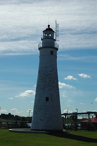
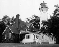
Fort Gratiot Light, the first lighthouse in the state of Michigan, was constructed north of Fort Gratiot in 1825 by Lucius Lyon, who later became one of Michigan's first U.S. Senators.

<span class="mw-page-title-main">Saginaw River Rear Range Light</span> Lighthouse in Michigan, United States

The first Saginaw River lighthouse was constructed from 1839 to 1841, in a period when large quantities of lumber were being harvested and shipped from the heart of Michigan via river and the Great Lakes to the East Coast of the United States via the Erie Canal and Hudson River. This connection to major eastern markets was critical to the development of central Michigan.

<span class="mw-page-title-main">Port Austin Light</span> Lighthouse in Michigan, United States

Port Austin Lighthouse is a lighthouse off the shore of Lake Huron, about 2.5 miles (4.0 km) north of Port Austin, Huron County Michigan sitting on a rocky reef (shoal), which is just north of the tip of the Thumb and a real hazard to navigation.

<span class="mw-page-title-main">Sturgeon Point Light</span> Lighthouse in Michigan, United States

The Sturgeon Point Light Station is a lighthouse on Lake Huron in Haynes Township, Alcona County, northeastern lower Michigan. Established to ward mariners off a reef that extends 1.5 miles (2.4 km) lakeward from Sturgeon Point, it is today regarded as a historic example of a Cape Cod style Great Lakes lighthouse.

<span class="mw-page-title-main">Au Sable Light</span> Lighthouse in Michigan, United States

Au Sable Light is an active lighthouse in the Pictured Rocks National Lakeshore west of Grand Marais, Michigan off H-58. Until 1910, this aid to navigation was called "Big Sable Light".

<span class="mw-page-title-main">Round Island Light, Michigan</span> Lighthouse in Michigan, United States

For the lighthouse of the same name in the St. Mary's River, see Round Island Light

<span class="mw-page-title-main">White Shoal Light, Michigan</span> Lighthouse in Michigan, United States

The White Shoal Light is a lighthouse located 20 miles (32 km) west of the Mackinac Bridge in Lake Michigan. It is an active aid to navigation. It is also the tallest lighthouse on the Great Lakes.

<span class="mw-page-title-main">Harbor Beach Light</span> Lighthouse in Michigan, United States

The Harbor Beach Lighthouse is a "sparkplug lighthouse" located at the end of the north breakwall entrance to the harbor of refuge on Lake Huron. The breakwall and light were created by the United States Army Corps of Engineers to protect the harbor of Harbor Beach, Michigan, which is the largest man-made freshwater harbor in the world. Harbor Beach is located on the eastern edge of the Thumb of Huron County, in the state of Michigan.

<span class="mw-page-title-main">Port Sanilac Light</span> Lighthouse in Michigan, United States

Port Sanilac Light is a United States Coast Guard lighthouse located on Point Sanilac, near Port Sanilac on the eastern side of Michigan's Thumb. It is an automated and active aid to navigation on Lake Huron.

<span class="mw-page-title-main">Marquette Harbor Light</span> Lighthouse in Michigan, United States

The Marquette Harbor Light is located on Lake Superior in Marquette, Michigan, a part of the Upper Peninsula. It is an active aid to navigation.

<span class="mw-page-title-main">Fourteen Foot Shoal Light</span> Lighthouse in Michigan, United States

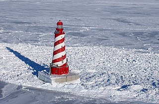
The lighthouse at Fourteen Foot Shoal was named to note that the lake is only 14 feet (4.3 m) deep at this point, which is a hazard to navigation, ships and mariners.

<span class="mw-page-title-main">Poe Reef Light</span> Lighthouse in Michigan, United States

Poe Reef is a lighthouse located at the east end of South Channel between Bois Blanc Island and the mainland of the Lower Peninsula, about 6 miles (9.7 km) east of Cheboygan, Michigan.

<span class="mw-page-title-main">Bois Blanc Light</span> Lighthouse in Michigan, United States

Bois Blanc Light can refer to one of five lighthouses erected on Bois Blanc Island, Michigan, in Lake Huron. Two of the lighthouses are currently standing. The lighthouse and surrounding property are privately owned and closed to the public.

<span class="mw-page-title-main">Waugoshance Light</span> Lighthouse in Michigan, United States

The ruined lighthouse at Waugoshance protects boats from a shoal area at the northern end of Lake Michigan. The lighthouse is located in Emmet County, Michigan, United States, and in U.S. Coast Guard District No. 9. It is approximately 15 miles (24 km) west of Mackinaw City. Due to erosion and deterioration, the lighthouse is deteriorating and critically endangered, and likely to fall into the lake in the near future.

<span class="mw-page-title-main">Sand Point Light</span> Lighthouse in Michigan, United States

The Sand Point Lighthouse is located in Escanaba, Michigan, United States, on Lake Michigan's northern shore. Since 1989, it has been an unofficial aid to navigation. Though it is an operational aid to navigation. The restored lighthouse is now open to the public during the summer months. It is also known as the Escanaba/Sand Point Light or the Escanaba Light.

References

  1. Pepper, Terry. "Database of Tower Heights". Seeing the Light. terrypepper.com. Archived from the original on 2000-09-18.
  2. Pepper, Terry. "Database of Focal Heights". Seeing the Light. terrypepper.com. Archived from the original on 2008-08-30.
  3. National Park Service, Maritime Heritage Project, Inventory of Lights, Cheboygan Crib Light. Archived July 6, 2008, at the Wayback Machine
  4. Light List, Volume VII, Great Lakes (PDF). Light List. United States Coast Guard.
  5. Amateur Radio Lighthouse Society, Cheboygan Crib (Lake Huron) Light ARLHS USA-160
  6. Amateur Radio Lighthouse Society, World List of Lights. Archived April 21, 2009, at the Wayback Machine
  7. Rowlett, Russ. "Lighthouses of the United States: Michigan's Eastern Lower Peninsula". The Lighthouse Directory. University of North Carolina at Chapel Hill.
  8. Michigan Lighthouse Fund, Cheboygan Crib Light. Archived January 6, 2009, at the Wayback Machine
  9. 1 2 3 Terry Pepper, Seeing the Light, Cheboygan Crib Light. Archived May 17, 2008, at the Wayback Machine
  10. "Historic Light Station Information and Photography: Michigan". United States Coast Guard Historian's Office. Archived from the original on 2017-05-01.
  11. Michigan Lighthouse Conservancy, Cheboygan Crib Light.
  12. Lighthouse Central, Cheboygan Crib light The Ultimate Guide to East Michigan Lighthouses by Jerry Roach (Publisher: Bugs Publishing LLC - July 2006). ISBN   0-9747977-1-5; ISBN   978-0-9747977-1-7.
  13. 1 2 Wobser, David, Cheboygan Crib Light, boatnerd.com. Archived May 17, 2008, at the Wayback Machine
  14. "Sanderson, Dan, Traverse City Record Eagle, "City will finally own light; Most thought they already did own it" July 27, 2003". Archived from the original on 2012-07-13. Retrieved 2008-06-29.
  15. 1 2 Anderson, Kraig, Lighthouse Friends, Cheboygan Crib Light. Archived May 13, 2011, at the Wayback Machine
  16. "Sheplers Ferry, Lighthouse Cruises". Archived from the original on 2008-05-11.
Vintage image of the light (on its crib and before being moved) Cheboygancrib.jpg
Vintage image of the light (on its crib and before being moved)