Station will give available information on fog conditions in upper river by radiotelephone when requested, (156.80MHz). Standby light of reduced intensity lighted throughout 24 hours.[4]
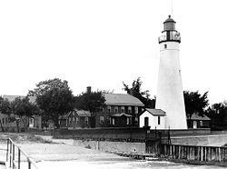
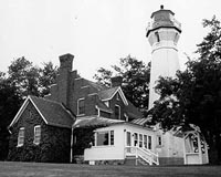
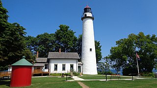
Fort Gratiot Light/ˈɡræʃɪt/, the first lighthouse in the state of Michigan, was constructed north of Fort Gratiot in 1825 by Lucius Lyon, who later became one of Michigan's first U.S. Senators.[8]
The Fort Gratiot Light marks the entrance to the St. Clair River from Lake Huron (going south) in the southern portion of Michigan's Thumb. The light is still active and the grounds are an active Coast Guard facility, but it has recently been handed over to the Port Huron Museum. It is the oldest surviving lighthouse in Michigan. There is also a public beach and park on the property, known as Lighthouse Beach.
With the completion of the Erie Canal, traffic in the Great Lakes increased dramatically. Coal was being brought from Michigan, stone (and more timber) was being brought from Wisconsin and the entrance to the St. Clair River became a bottleneck. In 1823, Congress appropriated $3,500 to construct a light in "Michigan Territory" near Fort Gratiot.
The contract for construction of the lighthouse and keeper's dwelling was awarded to Captain Winslow Lewis of Massachusetts. Lewis was the inventor of the patented Lewis lamp, which the Fifth Auditor[clarification needed] had universally adopted as the primary source of illumination in the nation's growing inventory of lighthouses. A staunch supporter and ally of the Fifth Auditor, Lewis had branched out into the business of lighthouse construction, and as the frequent low bidder, was being awarded a growing number of contracts to fulfill the nation's need for navigational aids on the East Coast.
Lewis sub-contracted the construction of the tower and keeper's dwelling that would become known as the "Fort Gratiot Light" to Daniel Warren of Rochester, New York. Work commenced on the structure, but appears to have been running far beyond the scope of the original bid, since Congress appropriated an additional $5,000 for the project's completion on April 2, 1825.[10]
This original tower was 32 feet (9.8m) tall.[11][12]
Even with the major cost overrun, it became quickly apparent that the structure was both poorly designed and constructed. George McDougall, a former Detroit lawyer of some ill repute[citation needed] was selected as the light's first official keeper. McDougall's reports indicated that the stairs were so steep that they had to be climbed sideways, and the trapdoor into the lantern room was barely large enough for a man to squeeze through. While McDougall no doubt reported with truth on this situation,[according to whom?] he was reputedly a short man with a weight in excess of 300pounds, and as such hired an assistant to perform all of his tower work.[10]
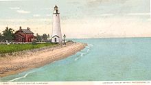
McDougall's concerns were supported when the tower was damaged during a storm in the fall of 1828, and later fell down. Congress reacted swiftly and appropriated $8,000 for a new tower in 1829. The new tower was 65 feet tall and 25' in diameter and it was outfitted with the Lewis lamp system (powered by whale oil) that was then the standard.
Soon after its establishment in 1852, the new US Lighthouse Board determined that the Lewis lamps universally accepted by the prior Pleasonton administration were significantly inferior to the French Fresnel lenses being adopted throughout the rest of the world. After conducting successful trials of the new lenses in a few East Coast lights, the Board decided to upgrade all lenses throughout the system. As a result, the Lewis lamps were removed from Fort Gratiot in 1857, and the tower was refitted with a fourth-order Fresnel lens, which had an intensity at least four times that of the old Lewis lamps.[10]
In 1874, a brick duplex keeper's house was built.[13]
As lake shipping continued to rise dramatically in the early second half of the century, it was determined that the Fort Gratiot Light needed further upgrading. To this end, in 1862 the government increased the height of the tower to 82 feet (25m), and the fourth-order Fresnel was replaced with a larger third-order lens, showing a fixed white light. The old fourth-order lens was taken to Saginaw and installed in the Saginaw River Lighthouse.[10]
The fog signal building was added in 1900, and a Coast Guard facility was constructed on land south of the lighthouse complex in 1932. The two facilities merged in 1939.
In 2004, the Port Huron U.S. Coast Guard station moved into a new headquarters adjacent to the light.[19]
The Coast Guard closed the lighthouse to visitors in August 2008 due to deteriorating brickwork and falling debris. A structural assessment and repairs will take place before the tower can reopen to the public.[20] Architects reported that almost $4 million would be required for a complete restoration. In 2009, these plans were jeopardized, when city council rejected a deed offered by the federal government because it found the financial requirements too burdensome. The St. Clair County Parks and Recreation department took over the lighthouse and grounds in September 2010 and reopened guided tours of the lighthouse in summer of 2012.[21]
Getting there
The Park is open daily from 7:00am to 10:00pm. Admission to the park grounds is free. Admission tickets are sold in the gift shop for tours of the station and tower. The park is located at 2800 Omar Street, in Port Huron.
When the grounds are closed to the public, there is a city park just north of the light with an excellent view from the beach.[22] Returning from Canada to Port Huron on the Blue Water Bridge, this light can be seen on the righthand side of one's motor vehicle.
Because it was positioned near the busy shipping lanes of the mid-19th century, a lighthouse was built on Granite Island in 1868 by the U.S. Lighthouse Board and commissioned in 1869.
The Whitefish Point Light is a lighthouse located in Chippewa County in the U.S. state of Michigan. Located on the southeastern shores of Lake Superior, it sits at the edge of Whitefish Point leading to Whitefish Bay. Constructed in 1849, it is the oldest operating lighthouse in the Upper Peninsula. All vessels entering or exiting Lake Superior pass near Whitefish Point. The area is infamously known as the "Graveyard of the Great Lakes" due to the high number of shipwrecks in the area, most famously the SS Edmund Fitzgerald.
The DeTour Reef Light is a non-profit-operated lighthouse marking the southern entrance of the DeTour Passage between the eastern end of Michigan's Upper Peninsula and Drummond Island. The light is an automated active aid to navigation. It marks the northern end of Lake Huron. The passage is used by almost all of the Great Lakes commercial freighter traffic moving to and from Lake Superior, with approximately 5,000 vessel movements annually. It is said to be "the gateway to Lake Superior." In addition, many recreational boaters use the passage. The Light is located in Lake Huron, three miles (5 km) south of the nearest town, DeTour Village, Michigan.
Charity Island Light is a lighthouse on Big Charity Island in Lake Huron just off the coast of Au Gres, Northern Michigan.
Old Mackinac Point Light is a deactivated lighthouse located at the northern tip of the Lower Peninsula in the U.S. state of Michigan. The lighthouse is part of Fort Michilimackinac State Park in the village of Mackinaw City just east of the Mackinac Bridge.
Forty Mile Point Light is a lighthouse in Presque Isle County near Hammond Bay on the western shore of Lake Huron in Rogers Township, Michigan USA.
The historic Grosse Point Light is located in Evanston, Illinois. Following several shipping disasters near Evanston, residents successfully lobbied the federal government for a lighthouse. Construction was completed in 1873. The lighthouse was added to the National Register of Historic Places on September 8, 1976. On 20 January 1999, the lighthouse was designated a National Historic Landmark. It is maintained under the jurisdiction of the Evanston Lighthouse Park District, an independent taxing authority.
Port Austin Lighthouse is a lighthouse off the shore of Lake Huron, about 2.5 miles (4.0 km) north of Port Austin, Huron County Michigan sitting on a rocky reef (shoal), which is just north of the tip of the Thumb and a real hazard to navigation.
The Sturgeon Point Light Station is a lighthouse on Lake Huron in Haynes Township, Alcona County, northeastern lower Michigan. Established to ward mariners off a reef that extends 1.5 miles (2.4 km) lakeward from Sturgeon Point, it is today regarded as a historic example of a Cape Cod style Great Lakes lighthouse.
Au Sable Light is an active lighthouse in the Pictured Rocks National Lakeshore west of Grand Marais, Michigan off H-58. Until 1910, this aid to navigation was called "Big Sable Light".
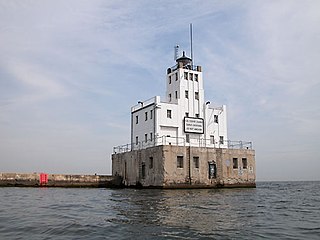
The Milwaukee Breakwater lighthouse was built in 1926 in the harbor of Milwaukee in Milwaukee County, Wisconsin to mark the entrance to the harbor. One of the last fully enclosed breakwater lighthouses in the Great Lakes, the structure was placed on the National Register of Historic Places in 2011.
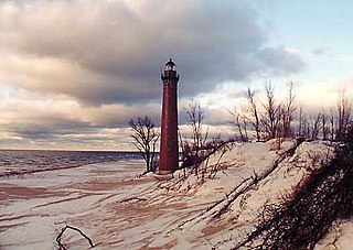
The Little Sable Point Light is a lighthouse located south of Pentwater in the lower peninsula of the U.S. state of Michigan. It is in the southwest corner of Golden Township, just south of Silver Lake State Park.
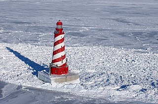
The White Shoal Light is a lighthouse located 20 miles (32 km) west of the Mackinac Bridge in Lake Michigan. It is an active aid to navigation. It is also the tallest lighthouse on the Great Lakes.
The Harbor Beach Lighthouse is a "sparkplug lighthouse" located at the end of the north breakwall entrance to the harbor of refuge on Lake Huron. The breakwall and light were created by the United States Army Corps of Engineers to protect the harbor of Harbor Beach, Michigan, which is the largest man-made freshwater harbor in the world. Harbor Beach is located on the eastern edge of the Thumb of Huron County, in the state of Michigan.
Port Sanilac Light is a United States Coast Guard lighthouse located on Point Sanilac, near Port Sanilac on the eastern side of Michigan's Thumb. It is an automated and active aid to navigation on Lake Huron.
Pointe aux Barques Lighthouse is an active lighthouse located in Huron County in the U.S. state of Michigan. It is located along the shores of Lake Huron on the northeastern tip of the Thumb. Originally constructed in 1848, it is one of the oldest active lighthouses in the state. The name is translated as "point of little boats" from the French language, which refers to the shallow coastline that poses a threat to larger boats.
The Marquette Harbor Light is located on Lake Superior in Marquette, Michigan, a part of the Upper Peninsula. It is an active aid to navigation.
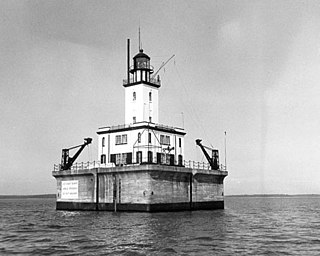
The lighthouse at Fourteen Foot Shoal was named to note that the lake is only 14 feet (4.3 m) deep at this point, which is a hazard to navigation, ships and mariners.
The Sand Point Lighthouse is located in Escanaba, Michigan, United States, on Lake Michigan's northern shore. Since 1989, it has been an unofficial aid to navigation. Though it is an operational aid to navigation. The restored lighthouse is now open to the public during the summer months. It is also known as the Escanaba/Sand Point Light or the Escanaba Light.
The Grand Island Harbor Rear Range Light is a lighthouse located off M-28 in Munising Township, Michigan. It is also known as the Bay Furnace Rear Range Light, Christmas Rear Range Light, or End of the Road Light. The corresponding front range light was replaced in 1968; the rear range light was listed on the National Register of Historic Places in 1990. It is no longer an active aid to navigation.
This page is based on this Wikipedia article Text is available under the CC BY-SA 4.0 license; additional terms may apply. Images, videos and audio are available under their respective licenses.