National Register of Historic Places listings in Muskegon County, Michigan

Last updated

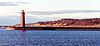
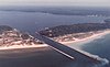
The following is a list of Registered Historic Places in Muskegon County, Michigan.

This National Park Service list is complete through NPS recent listings posted May 7, 2021. [1]
Map all coordinates using: OpenStreetMap  
Download coordinates as: KML
[2] Name on the Register [3] ImageDate listed [4] Location City or townDescription
1 Amazon Hosiery Mill
Amazon Hosiery Mill Amazon Knitting Mills.jpg
Amazon Hosiery Mill
April 15, 1982
(#82002857)
530-550 W. Western Ave.
43°14′01″N86°15′25″W / 43.233611°N 86.256944°W / 43.233611; -86.256944 (Amazon Hosiery Mill)
Muskegon
2 Central Fire Station
Central Fire Station Old Muskegon Firehouse.JPG
Central Fire Station
March 18, 1999
(#99000341)
75 W. Walton Ave.
43°14′04″N86°14′44″W / 43.234444°N 86.245556°W / 43.234444; -86.245556 (Central Fire Station)
Muskegon
3 Charles H. Hackley House
Charles H. Hackley House Hackley House.jpg
Charles H. Hackley House
July 8, 1970
(#70000282)
484 W. Webster Ave.
43°13′53″N86°15′32″W / 43.231389°N 86.258889°W / 43.231389; -86.258889 (Charles H. Hackley House)
Muskegon
4 Horatio N. Hovey House
Horatio N. Hovey House Horatio N. Hovey House.jpg
Horatio N. Hovey House
September 8, 1983
(#83000887)
318 Houston Ave.
43°13′53″N86°15′05″W / 43.231389°N 86.251389°W / 43.231389; -86.251389 (Horatio N. Hovey House)
Muskegon
5 Hume House
Hume House Hume House.jpg
Hume House
January 13, 1972
(#72000646)
472 W. Webster Ave.
43°13′53″N86°15′32″W / 43.231389°N 86.258889°W / 43.231389; -86.258889 (Hume House)
Muskegon
6 John C. and Augusta (Covell) Lewis House
John C. and Augusta (Covell) Lewis House John Lewis House.jpg
John C. and Augusta (Covell) Lewis House
December 13, 2010
(#10001027)
324 S. Mears Ave.
43°24′25″N86°20′52″W / 43.406944°N 86.347778°W / 43.406944; -86.347778 (John C. and Augusta (Covell) Lewis House)
Whitehall
7 Muskegon Historic District
Muskegon Historic District Hackley Park.jpg
Muskegon Historic District
September 27, 1972
(#72000647)
Bounded roughly by Clay, Muskegon, 2nd, and 6th Sts.
43°14′00″N86°15′15″W / 43.233333°N 86.254167°W / 43.233333; -86.254167 (Muskegon Historic District)
Muskegon
8 Muskegon South Breakwater Light
Muskegon South Breakwater Light MuskegonBreakwaterLight.jpg
Muskegon South Breakwater Light
November 15, 2006
(#06001026)
At south breakwater end in Lake Michigan, 0.4 mi (0.64 km). SW of Muskegon Lake entry channel
43°13′26″N86°20′48″W / 43.223889°N 86.346667°W / 43.223889; -86.346667 (Muskegon South Breakwater Light)
Muskegon
9 Muskegon South Pierhead Light
Muskegon South Pierhead Light MuskegonPierLight.jpg
Muskegon South Pierhead Light
February 14, 2006
(#06000036)
Southern pier of the Muskegon Lake entrance channel at Lake Michigan, 500 ft (150 m) from shore
43°13′36″N86°20′29″W / 43.226667°N 86.341389°W / 43.226667; -86.341389 (Muskegon South Pierhead Light)
Muskegon
10 Muskegon YMCA Building
Muskegon YMCA Building Muskegon YMCA.JPG
Muskegon YMCA Building
August 11, 1982
(#82002858)
297 W. Clay Ave.
43°14′07″N86°15′02″W / 43.235278°N 86.250556°W / 43.235278; -86.250556 (Muskegon YMCA Building)
Muskegon
11 Navigation Structures at White Lake Harbor
Navigation Structures at White Lake Harbor White Lake Harbor.jpg
Navigation Structures at White Lake Harbor
May 26, 2000
(#00000535)
Southern end of Lau Rd.
43°22′31″N86°25′34″W / 43.375278°N 86.426111°W / 43.375278; -86.426111 (Navigation Structures at White Lake Harbor)
Whitehall
12 Spring Creek Site June 20, 1972
(#72001475)
Address Restricted
Egelston Township [5]
13 SS CLIPPER
SS CLIPPER MilwaukeeClipperStarboardStern.jpg
SS CLIPPER
December 8, 1983
(#83003570)
2098 Lakeshore Dr. [6]
43°13′18″N86°17′45″W / 43.2218°N 86.2959°W / 43.2218; -86.2959 (SS CLIPPER)
Muskegon
14 U.S.S. SILVERSIDES
U.S.S. SILVERSIDES USS Silversides;0823622.jpg
U.S.S. SILVERSIDES
October 18, 1972
(#72000453)
Naval Reserve Center, Fulton and Bluff Sts.
43°13′39″N86°20′19″W / 43.2275°N 86.338611°W / 43.2275; -86.338611 (U.S.S. SILVERSIDES)
Muskegon
15 Union Depot
Union Depot Union Depot-Muskegon.jpg
Union Depot
December 7, 2000
(#00001489)
610 Western Ave.
43°13′59″N86°15′28″W / 43.233056°N 86.257778°W / 43.233056; -86.257778 (Union Depot)
Muskegon
Map all coordinates using: OpenStreetMap  
Download coordinates as: KML

See also

Related Research Articles

This is a list of properties and districts in Mississippi that are listed on the National Register of Historic Places. There are more than 1,400 sites distributed among all of Mississippi's 82 counties.

National Register of Historic Places listings in Michigan list article

This is a list of properties on the National Register of Historic Places in the U.S. state of Michigan.

The following is a list of Registered Historic Places in Allegan County, Michigan.

National Register of Historic Places listings in Berrien County, Michigan

This is a list of the National Register of Historic Places listings in Berrien County, Michigan.

The following is a list of Registered Historic Places in Bay County, Michigan.

National Register of Historic Places listings in Charlevoix County, Michigan

This is a list of the National Register of Historic Places listings in Charlevoix County, Michigan.

National Register of Historic Places listings in Chippewa County, Michigan

This is a list of the National Register of Historic Places listings in Chippewa County, Michigan.

The following is a list of Registered Historic Places in Grand Traverse County, Michigan.

National Register of Historic Places listings in Emmet County, Michigan

This is a list of the National Register of Historic Places listings in Emmet County, Michigan.

National Register of Historic Places listings in Delta County, Michigan Wikimedia list article

This is a list of the National Register of Historic Places listings in Delta County, Michigan.

The following is a list of Registered Historic Places in Kent County, Michigan.

National Register of Historic Places listings in Jackson County, Michigan

This is a list of the National Register of Historic Places listings in Jackson County, Michigan.

National Register of Historic Places listings in Marquette County, Michigan

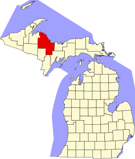
There are 38 properties or districts on the National Register of Historic Places in Marquette County in the US state of Michigan. The locations of National Register properties and districts in Marquette County for which the latitude and longitude coordinates are included below, may be seen in a map.

National Register of Historic Places listings in Mackinac County, Michigan

This is a list of the National Register of Historic Places listings in Mackinac County, Michigan.

The following is a list of Registered Historic Places in Ottawa County, Michigan.

The following is a list of Registered Historic Places in St. Clair County, Michigan.

National Register of Historic Places listings in Sanilac County, Michigan

This is a list of the National Register of Historic Places listings in Sanilac County, Michigan.

National Register of Historic Places listings in Saginaw County, Michigan

This is a list of the National Register of Historic Places listings in Saginaw County, Michigan.

National Register of Historic Places listings in Orange County, California

This is a list of the National Register of Historic Places listings in Orange County, California.

National Register of Historic Places listings in Gratiot County, Michigan

This is a list of the National Register of Historic Places listings in Gratiot County, Michigan.

References

  1. National Park Service, United States Department of the Interior, "National Register of Historic Places: Weekly List Actions", retrieved May 7, 2021.
  2. Numbers represent an alphabetical ordering by significant words. Various colorings, defined here, differentiate National Historic Landmarks and historic districts from other NRHP buildings, structures, sites or objects.
  3. "National Register Information System". National Register of Historic Places . National Park Service. April 24, 2008.
  4. The eight-digit number below each date is the number assigned to each location in the National Register Information System database, which can be viewed by clicking the number.
  5. The NRIS lists the Spring Creek Site as "Address Restricted," but various references (H. R. Crane; James B. Griffin (1968), "UNIVERSITY OF MICHIGAN RADIOCARBON DATES XII", Radiocarbon, 10: 61–114) give the approximate location in Egelston Township. The geo-coordinates are approximate.
  6. Location derived from this Clipper-associated website; the NRIS still lists it in its old location of Hammond, Indiana