This is intended to be a complete list of the properties and districts on the National Register of Historic Places in Alger County, Michigan, United States. Latitude and longitude coordinates are provided for many National Register properties and districts; these locations may be seen together in a map.[1]
There are 16 properties and districts listed on the National Register in the county.
The Au Sable Light Station was built in 1874 on Au Sable Point. The tower is a white brick conical tower with a black lantern; a red brick lightkeeper's house stands next door. Both were designed by Colonel Orlando Metcalfe Poe. The lighthouse was automated in 1958.
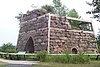
Bay Furnace was a blast furnace used for smelting iron. The furnace was constructed in 1869-70, and by 1874 was producing 15 tons of pig iron daily. A surrounding town, Onota, sprang up, and was soon home to 500 people. A disastrous fire in 1879 destroyed both the furnace and town; neither were rebuilt. The remains of the furnace were partially reconstructed later, and the site is now a campground.
The Grand Island Range Lights were lit first in 1868, but by 1914 were in poor repair. The new rear range light was a 64-foot (20m) tower, the upper half (painted white) of which was part of a tower originally located at the Vidal Shoals near Sault Ste. Marie. The front range light was replaced again in 1968, but both lights were deactivated in 1969.
Built in 1867 on a 175-foot tall cliff, the Grand Island North Light Station was the second lighthouse constructed at this site. The lighthouse was manned until 1941, and finally decommissioned in 1961. It is currently a privately owned summer home.
The Army Corps of Engineers began upgrading the harbor at Grand Marais in 1881, building a timber pile breakwater and two piers demarcating the entry into the harbor. Realizing that an added light would improve navigation, the Lighthouse Board requested funding for a light at the pierhead. This outer light was constructed in 1895; an inner light was added in 1898. Both are prefabricated skeletal iron or steel structures painted white and bolted to the pier. These lights are part of the Light Stations of the United States Multiple Property Submission.
This bridge, completed in 1919, was the last link in the Alger County trunk line road running from Trenary to Skandia. In 1919, the Michigan State Highway Department engineers designed what was designated as Trunk Line Bridge Number 264, based on a standard girder bridge design that the agency had developed in 1913–14.
Edward and Elizabeth Lobb owned the prosperous Princeton Mine in Marquette County and the Anna River Brick Company, founded in 1887. Edward Lobb died c. 1892, leaving the family's fortune to Elizabeth. She continued operating the brickyard along with her son Nathaniel, and in 1905-1906 built this house designed by Sault Ste. Marie architect Edward DeMar.
The bridge carrying M-28 over the Sand River is a medium-span concrete bridge with a shallow arch span, 4 feet thick at the abutments and 1'-8" at the center. The bridge has a so-called rigid-frame construction, which was a new development by the highway department at the time the bridge was built.
This bridge, now closed to vehicular traffic, carries what is now Wolkoff Road over the Au Train River. It is one of only two remaining bridges built to a 1907-1908 Michigan State Highway Department design standard for steel plate through girder bridges intended for mid-size spans of 30 to 60 feet.
The Mikulich General Store is a two-story rectangular building with a flat roof. The store was operated by the Mikulich family from 1926 to 1887, and served as the social and economic center for the Slovenian community of Traunik.
The Paulson Hose is a cedar log structure built in 1883 by Swedish immigrant Charles Paulson. The upper floor of the cabin was used as a school room in the early part of the 20th century. Paulson and his wife lived in the cabin until their deaths in 1925.
The Pickle Barrel House is a two-story cabin built of two barrels. The house design is based on cartoon characters, the Teenie Weenies, created by William Donahey. The barrel house was created as a large-scale version of the miniature oak casks used for Monarch-brand pickles, a food line that Donahey did advertisements for.
The Schoolcraft Furnace is an abandoned iron furnace. Construction began on the furnace in 1867, and by 1869 it was putting out 20 tons if pig iron daily. However, material shortages, poor management, and a depression in iron prices caused operations to be erratic. After several restarts, the furnace closed for good in 1878.
This is a list of properties on the National Register of Historic Places in the U.S. state of Michigan. This National Park Service list is complete through NPS recent listings posted June 14, 2024.
This is a list of the National Register of Historic Places listings in Berrien County, Michigan.
This is a list of the National Register of Historic Places listings in Charlevoix County, Michigan.
This is a list of the National Register of Historic Places listings in Delta County, Michigan.
This is a list of the National Register of Historic Places listings in Menominee County, Michigan.
This is a list of the National Register of Historic Places listings in Mackinac County, Michigan.
This is a list of the National Register of Historic Places listings in Saginaw County, Michigan.
This is a list of the National Register of Historic Places listings in Lancaster County, Pennsylvania.
This is a list of the National Register of Historic Places listings in Ross County, Ohio.
This is a list of the National Register of Historic Places listings in Lake County, California.
This is a list of the National Register of Historic Places listings in Greene County, Pennsylvania.
This is a list of the National Register of Historic Places listings in Jasper County, South Carolina.
This is a list of the National Register of Historic Places listings in Presque Isle County, Michigan.
The Thunder Lake II Site, also designated 20ST109, is an archaeological site located near Thunder Lake in Schoolcraft County, Michigan. The site dates from the Woodland period. It was listed on the National Register of Historic Places in 2014.
The Gooseneck Lake III Site, also designated 20DE43 , is an archaeological site located in Delta County, Michigan. The site dates from the Woodland period and is located about 60 feet from the water. It was listed on the National Register of Historic Places in 2014.
The Gooseneck Lake IV Site, also designated 20DE44 , is an archaeological site located in Delta County, Michigan. The site dates from the Woodland period. It was listed on the National Register of Historic Places in 2014.
The Jackpine Lake Site, also designated 20DE326 , is an archaeological site located in Delta County, Michigan. The site dates from the Woodland period and is about 90 feet from the water. It is located near a stand of wild rice. It was listed on the National Register of Historic Places in 2014.
The Bar Lake site, also designated 20AR437 , is an archaeological site located in Alger County, Michigan along the Indian River about 40 feet from the water and 1 km from the Widewaters site. It was listed on the National Register of Historic Places in 2014.
The Hartney Terrace site, also designated 20AR310 , is an archaeological site located in Alger County, Michigan. The site dates from the Woodland period, approximately 950 years before the present. It is located near a stand of wild rice. It was listed on the National Register of Historic Places in 2014.
The Widewaters site, also designated 20AR245 , is an archaeological site located in Alger County, Michigan. The site dates from the Woodland period, and is situated on a terrace above the Indian River about 30 ft (9.1 m) from the water, about 0.62 mi (1 km) from the Bar Lake site. It was used as a camp, and is near a stand of wild rice. It was listed on the National Register of Historic Places in 2014.
References
↑ The latitude and longitude information provided in this table was derived originally from the National Register Information System, which has been found to be fairly accurate for about 99% of listings. Some locations in this table may have been corrected to current GPS standards.
1 2 Numbers represent an alphabetical ordering by significant words. Various colorings, defined here, differentiate National Historic Landmarks and historic districts from other NRHP buildings, structures, sites or objects.
↑ The eight-digit number below each date is the number assigned to each location in the National Register Information System database, which can be viewed by clicking the number.
This page is based on this Wikipedia article Text is available under the CC BY-SA 4.0 license; additional terms may apply. Images, videos and audio are available under their respective licenses.