National Register of Historic Places listings in Saginaw County, Michigan

Last updated

Location of Saginaw County in Michigan Map of Michigan highlighting Saginaw County.svg
Location of Saginaw County in Michigan

This is a list of the National Register of Historic Places listings in Saginaw County, Michigan.

Contents

This is intended to be a complete list of the properties and districts on the National Register of Historic Places in Saginaw County, Michigan, United States. Latitude and longitude coordinates are provided for many National Register properties and districts; these locations may be seen together in a map. [1]

There are 41 properties and districts listed on the National Register in the county.


    This National Park Service list is complete through NPS recent listings posted June 16, 2023. [2]

Map all coordinates using: OpenStreetMap
Download coordinates as: KML

Current listings

[3] Name on the Register [4] ImageDate listed [5] Location City or townDescription
1 Bearinger Building
Bearinger Building Historic Downtown Saginaw buildings.jpg
Bearinger Building
July 9, 1982
(#82002861)
124 N. Franklin St.
43°26′02″N83°56′14″W / 43.4339°N 83.9372°W / 43.4339; -83.9372 (Bearinger Building)
Saginaw
2 Bliss Park
Bliss Park BlissParkSaginawMI.JPG
Bliss Park
December 7, 1995
(#95001424)
SW of jct. of Houghton St. and N. Michigan Ave.
43°25′42″N83°57′13″W / 43.4283°N 83.9536°W / 43.4283; -83.9536 (Bliss Park)
Saginaw
3 Abel Brockway House
Abel Brockway House Brockway House - Saginaw Michigan.jpg
Abel Brockway House
July 9, 1982
(#82002862)
1631 Brockway St.
43°25′03″N83°59′00″W / 43.4175°N 83.9833°W / 43.4175; -83.9833 (Abel Brockway House)
Saginaw
4 Bugai Site (20SA215) October 29, 1982
(#82000543)
Address Restricted [6]
43°20′00″N83°51′30″W / 43.333333°N 83.85833°W / 43.333333; -83.85833 (Bugai Site (20SA215))
Bridgeport
5 Castle Station
Castle Station Castle Museum 1 - Saginaw Michigan.jpg
Castle Station
January 13, 1972
(#72000652)
S. Jefferson at Federal St.
43°25′52″N83°56′08″W / 43.4311°N 83.9355°W / 43.4311; -83.9355 (Castle Station)
Saginaw Now known as Castle Museum of Saginaw County History
6 Center Road – Tittabawassee River Bridge November 30, 1999
(#99001458)
Center Rd. over Tittabawassee River
43°23′37″N84°00′54″W / 43.3936°N 84.0149°W / 43.3936; -84.0149 (Center Road – Tittabawassee River Bridge)
James Township Demolished in November 2009 and subsequently replaced. [7]
7 Central Warehouse
Central Warehouse CentralWarehouseSaginawMI.JPG
Central Warehouse
July 9, 1982
(#82002864)
1800 N. Michigan Ave.
43°26′01″N83°56′56″W / 43.4336°N 83.9489°W / 43.4336; -83.9489 (Central Warehouse)
Saginaw
8 Benjamin Cushway House
Benjamin Cushway House Benjamin Cushway House NRHP 82002865 Saginaw County, MI.jpg
Benjamin Cushway House
July 9, 1982
(#82002865)
Rust Ave. and Fordney St.
43°24′38″N83°57′40″W / 43.4106°N 83.9610°W / 43.4106; -83.9610 (Benjamin Cushway House)
Saginaw At the time of National Register listing, the Cushway House was located at 1404 S. Fayette Street, 43°24′35″N83°58′32″W / 43.4096°N 83.9755°W / 43.4096; -83.9755 (Cushway House (former location)) . It was relocated to its current location in 2001. [8]
9 Davis Carriage House
Davis Carriage House Davis Carriage House NRHP 82002863 Saginaw County, MI.jpg
Davis Carriage House
July 9, 1982
(#82002863)
519 N. Fayette St.
43°25′17″N83°57′40″W / 43.4213°N 83.9611°W / 43.4213; -83.9611 (Davis Carriage House)
Saginaw
10 East Genesee Historic Business District
East Genesee Historic Business District Baumgarten Building - E Genesee HBD - Saginaw Michigan.jpg
East Genesee Historic Business District
July 9, 1982
(#82002866)
Along E. Genesee Ave., bounded by Federal, Weadock, 2nd and Janes Sts.
43°25′49″N83°55′58″W / 43.4302°N 83.9327°W / 43.4302; -83.9327 (East Genesee Historic Business District)
Saginaw
11 East Saginaw Historic Business District
East Saginaw Historic Business District Saginaw Club - E Saginaw HBD - Saginaw Michigan.jpg
East Saginaw Historic Business District
July 9, 1982
(#82002867)
Roughly bounded by Federal, N. Water, N. Washington and N. Franklin Sts.
43°26′00″N83°56′20″W / 43.4333°N 83.9390°W / 43.4333; -83.9390 (East Saginaw Historic Business District)
Saginaw
12 Flint and Pere Marquette Railroad East Saginaw Depot
Flint and Pere Marquette Railroad East Saginaw Depot Flint & Pere Marquette Union Station, East Saginaw, Michigan.jpg
Flint and Pere Marquette Railroad East Saginaw Depot
November 29, 1996
(#96001378)
501 Potter St.
43°26′27″N83°55′59″W / 43.4408°N 83.9330°W / 43.4408; -83.9330 (Flint and Pere Marquette Railroad East Saginaw Depot)
Saginaw
13 Fosters Site (20SA74) October 29, 1982
(#82000544)
Address Restricted [9]
43°18′00″N83°56′00″W / 43.3°N 83.93333°W / 43.3; -83.93333 (Fosters Site (20SA74))
Fosters
14 The Grove
The Grove The Saginaw Waterworks has a maximum capacity of 52 million gallons a day (4330378847).jpg
The Grove
July 9, 1982
(#82002868)
S. Washington Ave.
43°24′58″N83°57′04″W / 43.4161°N 83.9511°W / 43.4161; -83.9511 (The Grove)
Saginaw
15 Gugel Bridge
Gugel Bridge Gugel Bridge - Frankenmuth Michigan.jpg
Gugel Bridge
March 15, 2000
(#00000217)
Beyer Rd. at the Cass River
43°19′45″N83°46′35″W / 43.3291°N 83.7764°W / 43.3291; -83.7764 (Gugel Bridge)
Frankenmuth Township
16 House at 1514 N. Michigan Street
House at 1514 N. Michigan Street 1514NMichiganSaginawMI.JPG
House at 1514 N. Michigan Street
July 9, 1982
(#82002869)
1514 N. Michigan Ave.
43°25′47″N83°57′02″W / 43.42965°N 83.9505°W / 43.42965; -83.9505 (House at 1514 N. Michigan Street)
Saginaw
17 Mahoney Site (20SA193) October 29, 1982
(#82000545)
Address Restricted [10]
43°16′00″N84°07′30″W / 43.266666°N 84.125°W / 43.266666; -84.125 (Mahoney Site (20SA193))
St. Charles
18 Michigan Bell Building
Michigan Bell Building Michigan Bell Building - Saginaw Michigan.jpg
Michigan Bell Building
July 9, 1982
(#82002870)
309 S. Washington Ave.
43°25′50″N83°56′25″W / 43.4306°N 83.9403°W / 43.4306; -83.9403 (Michigan Bell Building)
Saginaw
19 Morseville Bridge April 5, 1990
(#90000573)
Burt Rd. at Flint River
43°14′12″N83°52′06″W / 43.2367°N 83.8682°W / 43.2367; -83.8682 (Morseville Bridge)
Taymouth Township
20 Mower Road – Cole Drain Bridge December 17, 1999
(#99001537)
Mower Rd. over Cole Drain
43°19′39″N83°58′07″W / 43.3276°N 83.9686°W / 43.3276; -83.9686 (Mower Road – Cole Drain Bridge)
Spaulding Township
21 North Jefferson Avenue Historic District July 9, 1982
(#82002871)
Carroll and Jefferson Aves.
43°26′19″N83°56′05″W / 43.4386°N 83.9348°W / 43.4386; -83.9348 (North Jefferson Avenue Historic District)
Saginaw
22 North Michigan Avenue Historic District
North Michigan Avenue Historic District Saginaw Museum.jpg
North Michigan Avenue Historic District
July 9, 1982
(#82002872)
Roughly bounded by Monroe, Fayette, N. Hamilton and W. Remington Sts.
43°25′21″N83°57′24″W / 43.4225°N 83.9568°W / 43.4225; -83.9568 (North Michigan Avenue Historic District)
Saginaw
23 Parshallburg Bridge
Parshallburg Bridge Parshallburg Bridge.jpg
Parshallburg Bridge
October 12, 1994
(#94001168)
Ditch Rd. over the Shiawassee River, Chesaning Township
43°08′39″N84°08′06″W / 43.1441°N 84.1351°W / 43.1441; -84.1351 (Parshallburg Bridge)
Oakley Relocated to Chesaning in 1999, destroyed by flood in 2008. [11]
24 Passolt House
Passolt House Passolt House NRHP 72000653 Saginaw County, MI.jpg
Passolt House
October 18, 1972
(#72000653)
1105 S. Jefferson Ave.
43°25′15″N83°56′27″W / 43.4209°N 83.9407°W / 43.4209; -83.9407 (Passolt House)
Saginaw
25 Charles Peters Sr. House July 9, 1982
(#82002873)
130 N. 6th Ave.
43°25′58″N83°55′34″W / 43.432766°N 83.925985°W / 43.432766; -83.925985 (Charles Peters Sr. House)
Saginaw This house is missing and presumed demolished.
26 Roethke Houses
Roethke Houses Roethke Houses - Saginaw Michigan.jpg
Roethke Houses
June 8, 2001
(#00001485)
1759 and 1805 Gratiot Ave.
43°24′53″N83°59′15″W / 43.4148°N 83.98745°W / 43.4148; -83.98745 (Roethke Houses)
Saginaw
27 Russell Sackett House
Russell Sackett House 1604 Court St.jpg
Russell Sackett House
July 9, 1982
(#82002874)
1604 Court St.
43°25′28″N83°58′23″W / 43.4245°N 83.9731°W / 43.4245; -83.9731 (Russell Sackett House)
Saginaw
28 Saginaw Armory
Saginaw Armory Saginaw Armory - Saginaw Michigan.jpg
Saginaw Armory
March 13, 2002
(#02000161)
234 S. Water St.
43°25′53″N83°56′27″W / 43.4313°N 83.9407°W / 43.4313; -83.9407 (Saginaw Armory)
Saginaw
29 Saginaw Central City Historic Residential District
Saginaw Central City Historic Residential District Hill House 1 - Saginaw Central City HRD - Saginaw Michigan.jpg
Saginaw Central City Historic Residential District
February 1, 1979
(#79001168)
Roughly bounded by Federal Ave., S. Baum St., Park Ave., and Simoneau St.
43°25′37″N83°56′02″W / 43.426944°N 83.933889°W / 43.426944; -83.933889 (Saginaw Central City Historic Residential District)
Saginaw
30 Saginaw City Historic Business District
Saginaw City Historic Business District Bank of Saginaw c1910.jpg
Saginaw City Historic Business District
July 9, 1982
(#82002876)
Roughly bounded by Saginaw River, S. Michigan, Cleveland and Van Buren Aves.
43°25′01″N83°57′49″W / 43.4170°N 83.9635°W / 43.4170; -83.9635 (Saginaw City Historic Business District)
Saginaw
31 Saginaw County Fairgrounds Main Gate
Saginaw County Fairgrounds Main Gate Saginaw County Fairgrounds Main Gate 2 - Saginaw Michigan.jpg
Saginaw County Fairgrounds Main Gate
December 16, 2014
(#14001045)
2701 E. Genesee Ave.
43°24′26″N83°55′02″W / 43.4073°N 83.9171°W / 43.4073; -83.9171 (Saginaw County Fairgrounds Main Gate)
Saginaw
32 Saginaw News Building December 13, 2016
(#16000838)
203 S. Washington Ave.
43°25′54″N83°56′25″W / 43.431756°N 83.940215°W / 43.431756; -83.940215 (Saginaw News Building)
Saginaw
33 Schmidt Site July 27, 1973
(#73000958)
Address Restricted [12]
43°20′50″N83°55′10″W / 43.347222°N 83.919444°W / 43.347222; -83.919444 (Schmidt Site)
Bridgeport Also designated 20SA192
34 Schultz Site (20SA2) Green Point Site (20SA1) December 8, 1978
(#78002843)
Near Tittabawassee River and Shiawassee River [13]
43°23′10″N83°58′10″W / 43.386111°N 83.969444°W / 43.386111; -83.969444 (Schultz Site (20SA2) Green Point Site (20SA1))
Spaulding Township
35 South Jefferson Avenue Historic District
South Jefferson Avenue Historic District S Jefferson Avenue HD NRHP 82002877 Saginaw County, MI.jpg
South Jefferson Avenue Historic District
July 9, 1982
(#82002877)
Off M-13
43°25′02″N83°56′28″W / 43.4172°N 83.9410°W / 43.4172; -83.9410 (South Jefferson Avenue Historic District)
Saginaw
36 South Michigan Avenue Historic District July 9, 1982
(#82002878)
Roughly bounded by Fayette, Lyon, Lee and S. Hamilton Sts.
43°24′44″N83°58′14″W / 43.4122°N 83.9706°W / 43.4122; -83.9706 (South Michigan Avenue Historic District)
Saginaw
37 St. John's Episcopal Church
St. John's Episcopal Church St. John's Episcopal - Saginaw 01.jpg
St. John's Episcopal Church
July 9, 1982
(#82002879)
509 Hancock St.
43°25′07″N83°57′50″W / 43.4185°N 83.9640°W / 43.4185; -83.9640 (St. John's Episcopal Church)
Saginaw
38 State Street Bridge
State Street Bridge State Street Bridge - Bridgeport Michigan.jpg
State Street Bridge
November 29, 1995
(#95001391)
State St. (Fort Rd.) over the Cass River
43°21′29″N83°52′57″W / 43.3581°N 83.8826°W / 43.3581; -83.8826 (State Street Bridge)
Bridgeport
39 Wenzel House
Wenzel House Wenzel House - Saginaw Michigan.jpg
Wenzel House
July 9, 1982
(#82002880)
1203 S. Fayette St.
43°24′40″N83°58′28″W / 43.4112°N 83.9744°W / 43.4112; -83.9744 (Wenzel House)
Saginaw
40 West Side Historic Residential District July 9, 1982
(#82002881)
Roughly bounded by Mason, Madison, Harrison and Lyon Sts.
43°25′13″N83°58′06″W / 43.4203°N 83.9683°W / 43.4203; -83.9683 (West Side Historic Residential District)
Saginaw
41 Ammi and William Wright House
Ammi and William Wright House Wright House 3 - Saginaw Michigan.jpg
Ammi and William Wright House
July 9, 1982
(#82002882)
207 Garden Lane
43°24′50″N83°59′08″W / 43.4139°N 83.9856°W / 43.4139; -83.9856 (Ammi and William Wright House)
Saginaw

See also

Related Research Articles

This is a list of properties and historic districts in Tennessee that are listed on the National Register of Historic Places. There are over 2,000 in total. Of these, 29 are National Historic Landmarks. Each of Tennessee's 95 counties has at least one listing.

<span class="mw-page-title-main">National Register of Historic Places listings in Michigan</span>

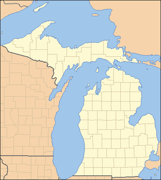
This is a list of properties on the National Register of Historic Places in the U.S. state of Michigan.
     This National Park Service list is complete through NPS recent listings posted June 16, 2023.

The following is a list of Registered Historic Places in Allegan County, Michigan.
     This National Park Service list is complete through NPS recent listings posted June 16, 2023.

<span class="mw-page-title-main">National Register of Historic Places listings in Berrien County, Michigan</span>

This is a list of the National Register of Historic Places listings in Berrien County, Michigan.

The following is a list of Registered Historic Places in Bay County, Michigan.
     This National Park Service list is complete through NPS recent listings posted June 16, 2023.

<span class="mw-page-title-main">National Register of Historic Places listings in Charlevoix County, Michigan</span>

This is a list of the National Register of Historic Places listings in Charlevoix County, Michigan.

<span class="mw-page-title-main">National Register of Historic Places listings in Delta County, Michigan</span>

This is a list of the National Register of Historic Places listings in Delta County, Michigan.

<span class="mw-page-title-main">National Register of Historic Places listings in Jackson County, Michigan</span>

This is a list of the National Register of Historic Places listings in Jackson County, Michigan.

<span class="mw-page-title-main">National Register of Historic Places listings in Mackinac County, Michigan</span>

This is a list of the National Register of Historic Places listings in Mackinac County, Michigan.

The following is a list of Registered Historic Places in Muskegon County, Michigan.
     This National Park Service list is complete through NPS recent listings posted June 16, 2023.

The following is a list of Registered Historic Places in Ottawa County, Michigan.
     This National Park Service list is complete through NPS recent listings posted June 16, 2023.

The following is a list of Registered Historic Places in St. Clair County, Michigan.
     This National Park Service list is complete through NPS recent listings posted June 16, 2023.

<span class="mw-page-title-main">National Register of Historic Places listings in Gratiot County, Michigan</span>

This is a list of the National Register of Historic Places listings in Gratiot County, Michigan.

<span class="mw-page-title-main">Charlevoix City Park Site</span> Archaeological site in Michigan, United States

The Charlevoix City Park Site is an archaeological site located between Bridge Street and Round Lake in Charlevoix, Michigan. It was listed on the National Register of Historic Places in 1972.

<span class="mw-page-title-main">Battle Point Site</span> Archaeological site in Michigan, United States

The Battle Point Site, also designated 20OT50, is an archaeological site located on Battle Point, along the Grand River in Crockery Township, Ottawa County, Michigan. It was listed on the National Register of Historic Places in 1973.

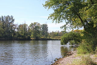
The Schultz site and the Green Point Site are two adjacent archaeological sites located near the confluence of the Tittabawassee River and Shiawassee River in Spaulding Township, Michigan. the two sites were listed together on the National Register of Historic Places in 1973.

The Bugai Site, designated 20SA215, is an archaeological site located near Bridgeport, Michigan. It was listed on the National Register of Historic Places in 1982.

The Fosters Site, designated 20SA74, is an archaeological site located near Bridgeport, Michigan. It was listed on the National Register of Historic Places in 1982.

The Mahoney Site, designated 20SA193, is an archaeological site located near Bridgeport, Michigan. It was listed on the National Register of Historic Places in 1982.

The Clark–Stringham site, designated 20-JA-37, is an archaeological site located near Jackson, Michigan. It was listed on the National Register of Historic Places in 1973.

References

  1. The latitude and longitude information provided in this table was derived originally from the National Register Information System, which has been found to be fairly accurate for about 99% of listings. Some locations in this table may have been corrected to current GPS standards.
  2. National Park Service, United States Department of the Interior, "National Register of Historic Places: Weekly List Actions", retrieved June 16, 2023.
  3. Numbers represent an alphabetical ordering by significant words. Various colorings, defined here, differentiate National Historic Landmarks and historic districts from other NRHP buildings, structures, sites or objects.
  4. "National Register Information System". National Register of Historic Places . National Park Service. April 24, 2008.
  5. The eight-digit number below each date is the number assigned to each location in the National Register Information System database, which can be viewed by clicking the number.
  6. The NRIS lists the location of the Bugai Site as "address restricted." References (Janet G. Brashler; Margaret B. Holman (1985), "Late Woodland Continuity and Change in the Saginaw Valley of Michigan", Arctic Anthropology, 22 (2): 141–152, JSTOR   40316095 ) indicate the approximate location, reflected by the geo-coordinates.
  7. "Center Road Bridge", HistoricBridges.org, archived from the original on July 7, 2015, retrieved July 6, 2015.
  8. Michigan Historical Commission, Michigan Historical Center (2005). The Cushway House (Michigan Historical Marker). Saginaw, MI: Michigan Department of Natural Resources . Retrieved July 16, 2015.
  9. The NRIS lists the location of Foster's Site as "address restricted." References (Maria E. Raviele (2010), ASSESSING CARBONIZED ARCHAEOLOGICAL COOKING RESIDUES: EVALUATION OF MAIZE PHYTOLITH TAPHONOMY AND DENSITY THROUGH EXPERIMENTAL RESIDUE ANALYSIS, Western Michigan University) indicate the approximate location, reflected by the geo-coordinates.
  10. The NRIS lists the location of the Mahoney Site as "address restricted." References (Janet G. Brashler; Margaret B. Holman (1985), "Late Woodland Continuity and Change in the Saginaw Valley of Michigan", Arctic Anthropology, 22 (2): 141–152, JSTOR   40316095 ) indicate the approximate location, reflected by the geo-coordinates.
  11. "Parshallburg Bridge (Ditch Road Bridge)", HistoricBridges.org, archived from the original on July 9, 2015, retrieved July 7, 2015.
  12. The Schmidt Site is listed as "address restricted," but references (Julie Stein (1974), The Schmidt Site: A Geologic Report, Western Michigan University) show the location. Geo-coordinates are approximate.
  13. The Schultz Site and Green Point Sites are listed as "address resticted;" however, references (William A. Lovis; Kathryn C. Egan-Bruhy; Beverley A. Smith; G. William Monaghan (October 2001), "Wetlands and Emergent Horticultural Economies in the Upper Great Lakes: A New Perspective from the Schultz Site", American Antiquity, 66 (4): 615–632, doi:10.2307/2694176, JSTOR   2694176 ) show the location near the confluence of the Tittabawassee and Shiawassee. Geocoordinates are approximate.