National Register of Historic Places listings in Huron County, Michigan

Last updated

The following is a list of Registered Historic Places in Huron County, Michigan.

Contents

This National Park Service list is complete through NPS recent listings posted May 7, 2021. [1]

Current listings

[2] Name on the Register [3] ImageDate listed [4] Location City or townDescription
1 Bay Port Historic Commercial Fishing District
Bay Port Historic Commercial Fishing District Bay Port Commercial Fishing Historic District 1974.jpg
Bay Port Historic Commercial Fishing District
September 22, 1977
(#77000714)
Saginaw Bay end of Lakeside Dr. and First St.
43°51′14″N83°22′25″W / 43.853889°N 83.373611°W / 43.853889; -83.373611 (Bay Port Historic Commercial Fishing District)
Bay Port
2 First Methodist Episcopal Church
First Methodist Episcopal Church First Methodist Episcopal Church Port Hope MI.jpg
First Methodist Episcopal Church
November 20, 1987
(#87001963)
4451 Second St.
43°56′22″N82°42′59″W / 43.939444°N 82.716389°W / 43.939444; -82.716389 (First Methodist Episcopal Church)
Port Hope
3 James and Jane Grice House
James and Jane Grice House GriceHouse-01s.jpg
James and Jane Grice House
November 12, 1982
(#82000534)
865 N. Huron Ave.
43°51′20″N82°39′12″W / 43.855556°N 82.653333°W / 43.855556; -82.653333 (James and Jane Grice House)
Harbor Beach
4 Grindstone City Historic District
Grindstone City Historic District Grindstone City Piers.jpg
Grindstone City Historic District
September 3, 1971
(#71000393)
On M-25
44°03′16″N82°53′53″W / 44.054444°N 82.898056°W / 44.054444; -82.898056 (Grindstone City Historic District)
Grindstone City
5 Harbor Beach Lighthouse
Harbor Beach Lighthouse Harbor Beach Lighthouse historic.jpg
Harbor Beach Lighthouse
August 4, 1983
(#83000850)
Breakwater Entrance
43°50′44″N82°37′51″W / 43.845556°N 82.630833°W / 43.845556; -82.630833 (Harbor Beach Lighthouse)
Harbor Beach
6 Herman House
Herman House Port Hope Hotel Port Hope MI.jpg
Herman House
November 20, 1987
(#87001974)
4405 Main St.
43°56′27″N82°42′46″W / 43.940833°N 82.712778°W / 43.940833; -82.712778 (Herman House)
Port Hope
7 Huron City Historic District
Huron City Historic District Huron City Historic District D.jpg
Huron City Historic District
April 28, 1995
(#95000446)
Pioneer Dr., Huron and Port Austin Townships
44°01′52″N82°49′57″W / 44.031111°N 82.8325°W / 44.031111; -82.8325 (Huron City Historic District)
Huron City
8 Indian Mission
Indian Mission Indian Mission2 NRHP 72000620 Huron County, MI.jpg
Indian Mission
September 22, 1972
(#72000620)
590 E. Bay St.
43°43′33″N83°26′32″W / 43.725833°N 83.442222°W / 43.725833; -83.442222 (Indian Mission)
Sebewaing
9 Charles G. Learned House
Charles G. Learned House CHARLES G. LEARNED HOUSE.jpg
Charles G. Learned House
May 31, 1984
(#84001400)
8544 Lake St.
44°02′32″N82°59′38″W / 44.042222°N 82.993889°W / 44.042222; -82.993889 (Charles G. Learned House)
Port Austin
10 Isaac Leuty House
Isaac Leuty House Isaac Leuty House Port Hope MI.jpg
Isaac Leuty House
November 20, 1987
(#87001975)
7955 School St.
43°56′26″N82°42′54″W / 43.940556°N 82.715°W / 43.940556; -82.715 (Isaac Leuty House)
Port Hope
11 Masonic Temple
Masonic Temple PortHopeHall-MI-01s.jpg
Masonic Temple
November 20, 1987
(#87001962)
4425 Main St.
43°56′28″N82°42′48″W / 43.941111°N 82.713333°W / 43.941111; -82.713333 (Masonic Temple)
Port Hope
12 Melligan Store-Agriculture Hall
Melligan Store-Agriculture Hall Melligan Store Port Hope MI.jpg
Melligan Store-Agriculture Hall
January 4, 1988
(#87001965)
4432 Main St.
43°56′30″N82°42′46″W / 43.941667°N 82.712778°W / 43.941667; -82.712778 (Melligan Store-Agriculture Hall)
Port Hope
13 Frank Murphy Birthplace
Frank Murphy Birthplace Frank Murphy Birthplace Harbor Beach MI 1969.jpg
Frank Murphy Birthplace
September 22, 1971
(#71000394)
142 S. Huron St.
43°50′33″N82°39′05″W / 43.8425°N 82.651389°W / 43.8425; -82.651389 (Frank Murphy Birthplace)
Harbor Beach
14 Navigation Structures at Harbor Beach Harbor
Navigation Structures at Harbor Beach Harbor Harbor Beach MI Harbor.jpg
Navigation Structures at Harbor Beach Harbor
September 11, 1997
(#97000972)
N. Lakeshore Dr.
43°50′54″N82°38′15″W / 43.848333°N 82.6375°W / 43.848333; -82.6375 (Navigation Structures at Harbor Beach Harbor)
Harbor Beach
15 Ogilvie Building
Ogilvie Building Ogilvie Building Port Hope MI.jpg
Ogilvie Building
November 20, 1987
(#87001973)
4443 Main St.
43°56′29″N82°42′49″W / 43.941389°N 82.713611°W / 43.941389; -82.713611 (Ogilvie Building)
Port Hope
16 Pointe Aux Barques Lighthouse
Pointe Aux Barques Lighthouse Pointe aux Barques Light and Oil House.jpg
Pointe Aux Barques Lighthouse
March 20, 1973
(#73000949)
East of Huron City on Light House Rd.
44°01′25″N82°45′20″W / 44.023611°N 82.755556°W / 44.023611; -82.755556 (Pointe Aux Barques Lighthouse)
Huron City
17 Port Austin Reef Light
Port Austin Reef Light Portaustinreef2.jpg
Port Austin Reef Light
September 15, 2011
(#11000666)
Port Austin Reef, 2.5 miles north of Port Austin (Port aux Barques Township)
44°04′55″N82°58′55″W / 44.081944°N 82.981944°W / 44.081944; -82.981944 (Port Austin Reef Light)
Port Austin vicinityLight Stations of the United States MPS
18 Albert E. Sleeper House
Albert E. Sleeper House GovernorSleepersRes.jpg
Albert E. Sleeper House
February 1, 1972
(#72000619)
228 W. Huron St. (M-53)
43°48′06″N83°00′16″W / 43.801667°N 83.004444°W / 43.801667; -83.004444 (Albert E. Sleeper House)
Bad Axe
19 Smith-Culhane House
Smith-Culhane House Smith-Culhane House.jpg
Smith-Culhane House
September 24, 2001
(#01001015)
8569 Lake St.
44°02′35″N82°59′41″W / 44.043056°N 82.994722°W / 44.043056; -82.994722 (Smith-Culhane House)
Port Austin
20 St. John's Lutheran Church
St. John's Lutheran Church St John Lutheran Church Port Hope MI.jpg
St. John's Lutheran Church
November 20, 1987
(#87001964)
4527 Second St.
43°56′26″N82°43′07″W / 43.940556°N 82.718611°W / 43.940556; -82.718611 (St. John's Lutheran Church)
Port Hope
21 Stafford House
Stafford House Stafford House Port Hope MI.jpg
Stafford House
January 25, 1973
(#73000950)
4467 Main St.
43°56′28″N82°42′53″W / 43.941111°N 82.714722°W / 43.941111; -82.714722 (Stafford House)
Port Hope
22 Frederick H. and Elizabeth Stafford House
Frederick H. and Elizabeth Stafford House Frederick Stafford House Port Hope MI.jpg
Frederick H. and Elizabeth Stafford House
November 20, 1987
(#87001976)
4489 Main St.
43°56′30″N82°42′53″W / 43.941667°N 82.714722°W / 43.941667; -82.714722 (Frederick H. and Elizabeth Stafford House)
Port Hope
23 W. R. Stafford Flour Mill and Elevator
W. R. Stafford Flour Mill and Elevator WR Stafford Flour Mill and Elevator Port Hope MI 1987.jpg
W. R. Stafford Flour Mill and Elevator
November 20, 1987
(#87001961)
4310 Huron St.
43°56′31″N82°42′29″W / 43.941944°N 82.708056°W / 43.941944; -82.708056 (W. R. Stafford Flour Mill and Elevator)
Port Hope
24 W. R. Stafford Planing Mill Site
W. R. Stafford Planing Mill Site WR Stafford Planing Mill Site Port Hope MI 1985.jpg
W. R. Stafford Planing Mill Site
November 20, 1987
(#87001960)
Huron St.
43°56′29″N82°42′27″W / 43.941389°N 82.7075°W / 43.941389; -82.7075 (W. R. Stafford Planing Mill Site)
Port Hope
25 W. R. Stafford Saw Mill Site
W. R. Stafford Saw Mill Site Stafford Saw Mill Site Port Hope MI.jpg
W. R. Stafford Saw Mill Site
November 20, 1987
(#87001959)
4451 Huron St. (at Stafford County Park)
43°56′37″N82°42′32″W / 43.943611°N 82.708889°W / 43.943611; -82.708889 (W. R. Stafford Saw Mill Site)
Port Hope
26 W. R. Stafford Worker's House
W. R. Stafford Worker's House Stafford Workers House Port Hope MI.jpg
W. R. Stafford Worker's House
November 20, 1987
(#87001978)
8022 Cedar St.
43°56′22″N82°42′40″W / 43.939444°N 82.711111°W / 43.939444; -82.711111 (W. R. Stafford Worker's House)
Port Hope
27 Winsor and Snover Bank Building
Winsor and Snover Bank Building Winsor and Snover Bank Building.jpg
Winsor and Snover Bank Building
March 19, 1987
(#87000482)
8648 Lake St.
44°02′40″N82°59′38″W / 44.044444°N 82.993889°W / 44.044444; -82.993889 (Winsor and Snover Bank Building)
Port Austin
Map all coordinates using: OpenStreetMap  
Download coordinates as: KML

See also

Related Research Articles

National Register of Historic Places listings in Emmet County, Michigan

This is a list of the National Register of Historic Places listings in Emmet County, Michigan.

The following is a list of Registered Historic Places in Eaton County, Michigan.

National Register of Historic Places listings in Ingham County, Michigan

This is a list of the National Register of Historic Places listings in Ingham County, Michigan.

The following is a list of Registered Historic Places in Ionia County, Michigan.

The following is a list of Registered Historic Places in Livingston County, Michigan.

National Register of Historic Places listings in Leelanau County, Michigan

This is a list of the National Register of Historic Places listings in Leelanau County, Michigan.

The following is a list of Registered Historic Places in Kent County, Michigan.

The following is a list of Registered Historic Places in Kalamazoo County, Michigan.

National Register of Historic Places listings in Manistee County, Michigan

This is a list of the National Register of Historic Places listings in Manistee County, Michigan.

The following is a list of Registered Historic Places in Ottawa County, Michigan.

National Register of Historic Places listings in Sanilac County, Michigan

This is a list of the National Register of Historic Places listings in Sanilac County, Michigan.

The following is a list of Registered Historic Places in Tuscola County, Michigan.

National Register of Historic Places listings in Erie County, Ohio

This is a list of the National Register of Historic Places listings in Erie County, Ohio.

National Register of Historic Places listings in Seneca County, Ohio

This is a list of the National Register of Historic Places listings in Seneca County, Ohio.

National Register of Historic Places listings in Richland County, Ohio

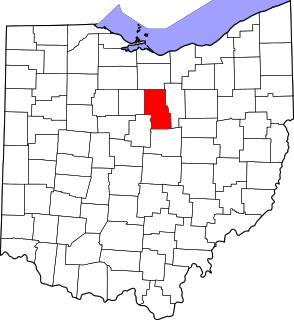
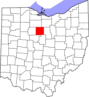
This is intended to be a complete list of the properties and districts on the National Register of Historic Places in Richland County, Ohio, United States. The locations of National Register properties and districts for which the latitude and longitude coordinates are included below, may be seen in an online map.

National Register of Historic Places listings in Crawford County, Ohio

This is a list of the National Register of Historic Places listings in Crawford County, Ohio.

National Register of Historic Places listings in Ashland County, Ohio

This is a list of the National Register of Historic Places listings in Ashland County, Ohio.

National Register of Historic Places listings in Huron County, Ohio

This is a list of the National Register of Historic Places listings in Huron County, Ohio.

National Register of Historic Places listings in Sandusky County, Ohio

This is a list of the National Register of Historic Places listings in Sandusky County, Ohio.

National Register of Historic Places listings in Gratiot County, Michigan

This is a list of the National Register of Historic Places listings in Gratiot County, Michigan.

References

  1. National Park Service, United States Department of the Interior, "National Register of Historic Places: Weekly List Actions", retrieved May 7, 2021.
  2. Numbers represent an alphabetical ordering by significant words. Various colorings, defined here, differentiate National Historic Landmarks and historic districts from other NRHP buildings, structures, sites or objects.
  3. "National Register Information System". National Register of Historic Places . National Park Service. April 24, 2008.
  4. The eight-digit number below each date is the number assigned to each location in the National Register Information System database, which can be viewed by clicking the number.