Devils Island (Wisconsin)

Last updated
Lighthouse Devils Island Lighthouse August 2012.jpg
Lighthouse

Devils Island is one of the twenty-two Apostle Islands of northern Wisconsin (USA), and has also been known as Louisiana Island (Henry R. Schoolcraft's 1820 map), Barney and Lamborn's Island (Asaph Whittlesey's 1871 map), Brownstone Island, and Rabbit Island.

Contents

The island is located in western Lake Superior off the Bayfield Peninsula, is centered at approximately 47°04'16.50" N 90°43'36.33" W and has a maximum elevation of 652' above sea level. The island rises only 50' above Lake Superior's official elevation of 602'. It is 318 acres in area. [1]

The island has no human inhabitants other than summer Park Service volunteers. It is managed by the National Park Service as part of the Apostle Islands National Lakeshore.

The politician and author Samuel Fifield wrote in 1899 that, "The Indians in the early days declared it to be the home of Matchimanitou, the "evil spirit," whom Kitchie-Manitouo, the "great spirit," had imprisoned there. Hence its name, Devils Island." Governor Fifield did not specify his source of information for this claim, and some modern Native scholars question the accuracy of this explanation.

When surf on the lake is heavy, the waves thunder and boom in the island's extensive sea caves. The rumbling can be heard even well away from the shoreline. Local residents claim that the Ojibwe (Chippewa) interpreted this noise as the sound of evil spirits.

Devils Island Sandstone Ripples SandStoneRipples.jpg
Devils Island Sandstone Ripples
Seacaves Devils Island Seacaves Lake Superior.jpg
Seacaves

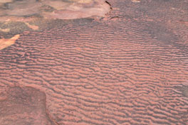
The island is perhaps most visited for the dramatic rock formations and sea caves that wrap around its northern shore. It is popular with kayakers who enjoy meandering in and out of the caves on calm days. The caves were sculpted from the billion year old sandstone bedrock exposed through the island's surface. The red and gold sandstone was deposited over the area by wandering streams from western hills. The undulating of the climate over about a million year period laid a sandstone crust that is about 1800 feet thick. They are colorfully stratified. Similar to ripples on the sandy bottom of a lake or stream caused by wind, waves or current, the ripples on these rocks are from gentle waves that passed 1 billion years ago. [2]

The Devils Island Light located at the northern end of the island is staffed by a volunteer ranger during the busy months of the summer. Accompanied by the volunteer, visitors may climb the tower, and go inside the original keeper's quarters, built in 1894. The lighthouse contains a 3rd order fresnel lens, the only Apostle Islands lighthouse to have its original lens. Close examination of the lens shows multiple cracks and damage that occurred when the US Coast Guard removed the lens in 1989. After local outcry and legal action, the Park Service was able to return the lens to the lighthouse in 1992.

Visitors are free to wander the grounds and enjoy many trails found on the island. Starting at the light station, they include a short trails to the east "landing", a loop trail to the west "landing" as well as a longer trail down the center of the island to the boathouse and dock at the south end.

Devils Island Tramway Engine House TrainStationInWoods.jpg
Devils Island Tramway Engine House

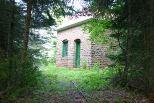
To the east is an old engine house that was used to haul supplies up from the landing. The building, thought to have been finished in 1901, is the only one built of sandstone quarried from the island. The bulldozer that was used to make these trails can be found along the trail to the west landing. A rare heath rush (grass) found on Devil's Island is thought to have been carried to the island on the tracks of the army surplus bulldozer which was once used in Greenland.

The northern tip of Devils Island is the northernmost point of Wisconsin.

47°04′16.5″N90°43′36.33″W / 47.071250°N 90.7267583°W / 47.071250; -90.7267583

See also

Notes

  1. Devils Island Light Station Cultural Landscape Retrieved March 16, 2022
  2. Neuhfer and Dalles, A Guidebook to the Geology of Lake Superior's Apostle Islands

Related Research Articles

<span class="mw-page-title-main">Makapuʻu</span> The extreme eastern end of the Island of Oʻahu in the Hawaiian Islands

Makapuʻu is the extreme eastern end of the Island of Oʻahu in the Hawaiian Islands, comprising the remnant of a ridge that rises 647 feet (197 m) above the sea. The cliff at Makapuʻu Point forms the eastern tip and is the site of a prominent lighthouse. The place name of this area, meaning "bulging eye" in Hawaiian, is thought to derive from the name of an image said to have been located in a cave here called Keanaokeakuapōloli. The entire area is quite scenic and a panoramic view is presented at the lookout on Kalanianaole Highway where the roadway surmounts the cliff just before turning south towards leeward Oʻahu and Honolulu.

<span class="mw-page-title-main">Mission Point Light</span> Lighthouse in Michigan, United States

Mission Point Light is a lighthouse located in the U.S. state of Michigan at the end of Old Mission Point, a peninsula jutting into Grand Traverse Bay 17 miles (27 km) north of Traverse City. When it was built in 1870, it was an exact copy of the Mama Juda Light, which was built on the Detroit River in 1866.

<span class="mw-page-title-main">Apostle Islands National Lakeshore</span> 69,372 acres in Wisconsin (US) managed by the National Park Service

The Apostle Islands National Lakeshore is a U.S. national lakeshore consisting of 21 islands and shoreline encompassing 69,372 acres (28,074 ha) on the northern tip of Wisconsin on the shore of Lake Superior. It is known for its collection of historic lighthouses, sandstone sea caves, a few old-growth remnant forests, and natural animal habitats. It is featured on the America the Beautiful Quarters series.

<span class="mw-page-title-main">Apostle Islands</span> Lake Superior archipelago in northern Wisconsin

The Apostle Islands are a group of 22 islands in Lake Superior, off the Bayfield Peninsula in northern Wisconsin. The majority of the islands are located in Ashland County—only Sand, York, Eagle, and Raspberry Islands are located in Bayfield County. All the islands except for Madeline Island are part of the Apostle Islands National Lakeshore. The islands in Ashland County are all in the Town of La Pointe, except for Long Island, which is in the Town of Sanborn, while those in Bayfield County are in the Towns of Russell and Bayfield.

The Grand Island National Recreation Area is a national recreation area in Hiawatha National Forest under jurisdiction of the U.S. Forest Service. Located on Grand Island, Michigan offshore from Munising, Michigan, the Grand Island National Recreation Area covers approximately 13,500 acres (55 km2) of Lake Superior woodland. Grand Island's glacier-cut lake shoreline measures approximately 35 miles (56 km) in length. The island's maximum dimension is 8 miles (13 km) from north to south. Grand Island was designated a national recreation area by the U.S. Congress in 1990 after the U.S. Forest Service purchased the island from its former owner, Cleveland Cliffs Iron Co.

<span class="mw-page-title-main">Michigan Island</span>

Michigan Island is one of the Apostle Islands located in western Lake Superior, off the Bayfield Peninsula, in northern Wisconsin. This island has no human inhabitants, and is managed by the National Park Service as part of the Apostle Islands National Lakeshore. It is centered at approximately 46.87° N 90.49° W and has a maximum elevation of 758' above sea level. Along its shores, it rises about 48 feet above Lake Superior's official elevation of 602'. The Michigan Island Light, which has two towers, is located on the island.

<span class="mw-page-title-main">Michigan Island Light</span> Lighthouse

The Michigan Island Lighthouse is a lighthouse operated by the National Park Service and located on Michigan Island on western Lake Superior in the Apostle Islands National Lakeshore.

<span class="mw-page-title-main">La Pointe Light</span> Lighthouse

The La Pointe Light is a lighthouse located on Long Island, one of the Apostle Islands, in Lake Superior in Ashland County, Wisconsin, near the city of Bayfield.

<span class="mw-page-title-main">Chequamegon Point Light</span> Lighthouse

The Chequamegon Point Lighthouse is a lighthouse located on Long Island, one of the Apostle Islands, in Lake Superior in Ashland County, Wisconsin, near the city of Bayfield.

<span class="mw-page-title-main">Devils Island Light</span> Lighthouse

The Devils Island Lighthouse is a lighthouse located on Devils Island, one of the Apostle Islands, in Lake Superior in Ashland County, Wisconsin, near the city of Bayfield. Among the Apostle Islands lighthouses—a testament to its remoteness—it was the last built, and the last automated and unmanned.

<span class="mw-page-title-main">Outer Island Light</span> Lighthouse in Wisconsin, United States

The Outer Island lighthouse is a lighthouse located on the northern tip of Outer Island, one of the Apostle Islands, in Lake Superior in Ashland County, Wisconsin, near the city of Bayfield.

<span class="mw-page-title-main">Apostle Islands Lighthouses</span> United States historic place

There are several historic lighthouses on Lake Superior on or near the Apostle Islands in Wisconsin. Six of these lighthouses, all in the Apostle Islands National Lakeshore, were listed as a group on the National Register of Historic Places in 1977 under the name Apostle Islands Lighthouses.

<span class="mw-page-title-main">Raspberry Island Light</span> Lighthouse

The Raspberry Island Lighthouse is a lighthouse located on the southern part of Raspberry Island, marking the west channel of the Apostle Islands in Lake Superior in Bayfield County, Wisconsin, near the city of Bayfield. It was erected in 1862, marking the western channel.

<span class="mw-page-title-main">Sand Island Light (Wisconsin)</span> Lighthouse in Wisconsin, United States

The Sand Island Light is a lighthouse located on the northern tip of Sand Island, one of the Apostle Islands, in Lake Superior in Bayfield County, Wisconsin, near the city of Bayfield.

<span class="mw-page-title-main">Forty Mile Point Light</span> Lighthouse in Michigan, United States

Forty Mile Point Light is a lighthouse in Presque Isle County near Hammond Bay on the western shore of Lake Huron in Rogers Township, Michigan USA.

<span class="mw-page-title-main">Point Cabrillo Light</span> Lighthouse in northern California

Point Cabrillo Light is a lighthouse in northern California, United States, between Point Arena and Cape Mendocino, just south of the community of Caspar. It has been a federal aid to navigation since 1909. It is part of the California state park system as Point Cabrillo Light Station State Historic Park.

<span class="mw-page-title-main">Au Sable Light</span> Lighthouse in Michigan, United States

Au Sable Light is an active lighthouse in the Pictured Rocks National Lakeshore west of Grand Marais, Michigan off H-58. Until 1910, this aid to navigation was called "Big Sable Light".

<span class="mw-page-title-main">Isle Royale Light</span> Lighthouse on Isle Royale in Michigan, United States

The Isle Royale Light, or Menagerie Island Light, is a lighthouse within Isle Royale National Park, in Keweenaw County, northern Michigan, United States.

<span class="mw-page-title-main">Raspberry Island (Wisconsin)</span> Island in Wisconsin, United States

Raspberry Island is one of the Apostle Islands in northern Wisconsin, in Lake Superior, and is part of the Apostle Islands National Lakeshore. The island is part of the Town of Russell, in Bayfield County. The Raspberry Island Light is located on the island.

<span class="mw-page-title-main">Outer Island (Wisconsin)</span> Island in Wisconsin, United States

Outer Island is one of the Apostle Islands, in Lake Superior, in northern Wisconsin, and is part of the Apostle Islands National Lakeshore. It is the easternmost, and third largest of the Apostle Islands. The Outer Island Light is on the northern part of the island. The island is part of the Town of La Pointe, Wisconsin.