Lime Ridge, Wisconsin

Last updated
Lime Ridge, Wisconsin
LimeRidgeWisconsin2.jpg
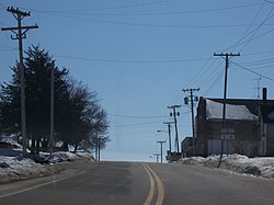
Looking south at Lime Ridge
Sauk County Wisconsin Incorporated and Unincorporated areas Lime Ridge Highlighted.svg
Location of Lime Ridge in Sauk County, Wisconsin.
Coordinates: 43°28′5″N90°9′13″W / 43.46806°N 90.15361°W / 43.46806; -90.15361 Coordinates: 43°28′5″N90°9′13″W / 43.46806°N 90.15361°W / 43.46806; -90.15361
Country Flag of the United States.svg  United States
State Flag of Wisconsin.svg  Wisconsin
County Sauk
Area
[1]
  Total1.00 sq mi (2.59 km2)
  Land1.00 sq mi (2.59 km2)
  Water0.00 sq mi (0.00 km2)
Elevation
[2]
1,181 ft (360 m)
Population
 (2010) [3]
  Total162
  Estimate 
(2019) [4]
163
  Density162.84/sq mi (62.89/km2)
Time zone UTC-6 (Central (CST))
  Summer (DST) UTC-5 (CDT)
Area code(s) 608
FIPS code 55-44225 [5]
GNIS feature ID1568058 [2]

Lime Ridge is a village in Sauk County, Wisconsin, United States. The population was 162 at the 2010 census.

Contents

Geography

Lime Ridge is located at 43°28′5″N90°9′13″W / 43.46806°N 90.15361°W / 43.46806; -90.15361 (43.468074, -90.153701). [6]

According to the United States Census Bureau, the village has a total area of 1.01 square miles (2.62 km2), all of it land. [7] [8]

History

The earliest settlers of Lime Ridge, as they arrived in the late 1850s, cleared the land of timber to plant crops, though others used the hardwood to make and sell railroad ties and stave bolts. [9] The first post office was established in 1858. [10] In 1867, Wesley Marsh opened a store, which was sold a few years later to John T. Pollock, and again in 1876 to Robert L. Bohn, an Ohio family that also built a dam and sawmill. Bohn bought hardwood timber from area farmers and converted it to barrel staves shipped to urban markets. [10] Bohn also opened a hotel and in 1909 founded the State Bank of Lime Ridge. [9] In 1874, the United Brethren opened a house of worship, used too by Baptists and Methodists in the community. In 1890, an Adventist church served members of that faith. After the population of German immigrants rose, in 1906 Trinity Lutheran church was built to serve that community. In 1912, St. Boniface Church was formed to serve the Catholic community. [11]

Lime Ride was incorporated in 1913. Rural electrification reached the village in 1922; the population at that time had risen to about 200. [12] The Great Depression together with World War II proved crippling to the local economy; the bank and hotel closed, and several other businesses followed. Many residents today work in other places.

Demographics

Historical population
CensusPop.
1920 256
1930 230−10.2%
1940 197−14.3%
1950 183−7.1%
1960 152−16.9%
1970 20333.6%
1980 191−5.9%
1990 152−20.4%
2000 16911.2%
2010 162−4.1%
2019 (est.)163 [4] 0.6%
U.S. Decennial Census [13]

2010 census

As of the census [3] of 2010, there were 162 people, 70 households, and 44 families living in the village. The population density was 160.4 inhabitants per square mile (61.9/km2). There were 78 housing units at an average density of 77.2 per square mile (29.8/km2). The racial makeup of the village was 99.4% White and 0.6% Native American.

There were 70 households, of which 28.6% had children under the age of 18 living with them, 51.4% were married couples living together, 4.3% had a female householder with no husband present, 7.1% had a male householder with no wife present, and 37.1% were non-families. 25.7% of all households were made up of individuals, and 10% had someone living alone who was 65 years of age or older. The average household size was 2.31 and the average family size was 2.77.

The median age in the village was 44.5 years. 20.4% of residents were under the age of 18; 5% were between the ages of 18 and 24; 26% were from 25 to 44; 30.9% were from 45 to 64; and 17.9% were 65 years of age or older. The gender makeup of the village was 52.5% male and 47.5% female.

2000 census

As of the census [5] of 2000, there were 169 people, 69 households, and 48 families living in the village. The population density was 167.3 people per square mile (64.6/km2). There were 77 housing units at an average density of 76.2 per square mile (29.4/km2). The racial makeup of the village was 100.00% White. Hispanic or Latino of any race were 0.59% of the population.

There were 69 households, out of which 30.4% had children under the age of 18 living with them, 62.3% were married couples living together, 7.2% had a female householder with no husband present, and 29.0% were non-families. 18.8% of all households were made up of individuals, and 11.6% had someone living alone who was 65 years of age or older. The average household size was 2.45 and the average family size was 2.82.

In the village, the population was spread out, with 23.7% under the age of 18, 6.5% from 18 to 24, 32.5% from 25 to 44, 18.3% from 45 to 64, and 18.9% who were 65 years of age or older. The median age was 38 years. For every 100 females, there were 116.7 males. For every 100 females age 18 and over, there were 104.8 males.

The median income for a household in the village was $41,500, and the median income for a family was $41,000. Males had a median income of $35,625 versus $19,500 for females. The per capita income for the village was $17,006. About 5.6% of families and 4.6% of the population were below the poverty line, including none of those under the age of eighteen or sixty five or over.
Notable person

Images

Related Research Articles

Simpson, Illinois Village in Illinois, United States

Simpson is a village in Johnson County, Illinois, United States. The population was 60 at the 2010 census.

Rock City, Illinois Village in Illinois, United States

Rock City is a village in Stephenson County, Illinois. The population was 315 at the 2010 census, up from 313 in 2000.

Quincy Township, Branch County, Michigan Township in Michigan, United States

Quincy Township is a civil township of Branch County in the U.S. state of Michigan. The population was 4,285 at the 2010 census.

Rice, Minnesota City in Minnesota, United States

Rice is a city in Benton County, Minnesota, United States. The population was 1,275 at the 2010 census. Its zip code also encompasses Graham, Langola, and Watab townships.

Oak Ridge, Missouri Village in Missouri, United States

Oak Ridge is a village in the southern part of Apple Creek Township in Cape Girardeau County, Missouri, United States. The population was 243 at the 2010 census. It is part of the Cape Girardeau–Jackson, MO-IL Metropolitan Statistical Area.

Harwood, Missouri Village in Missouri, United States

Harwood is a village in Vernon County, Missouri, United States. The population was 47 at the 2010 census. It was estimated to be 45 by the City of Harwood as of July 1, 2019.

McLean, Nebraska Village in Nebraska, United States

McLean is a village in Pierce County, Nebraska, United States. It is part of the Norfolk, Nebraska Micropolitan Statistical Area. The population was 36 at the 2010 census.

Litchfield, Nebraska Village in Nebraska, United States

Litchfield is a village in Sherman County, Nebraska, United States. The population was 262 at the 2010 census.

Sauk Centre, Minnesota City in Minnesota, United States

Sauk Centre is a city in Stearns County, Minnesota, United States. The population was 4,317 at the 2010 census. Sauk Centre is part of the St. Cloud Metropolitan Statistical Area.

Genoa, Ohio Village in Ohio, United States

Genoa is a village in Ottawa County, Ohio, United States. The population was 2,336 at the 2010 census. Originally settled as Stony Ridge, it took its present name in 1856 and was incorporated as a village in 1868.

Silver Lake, Ohio Village in Ohio, United States

Silver Lake is a village in Summit County, Ohio, United States. It is a suburb of Akron and is part of the Akron Metropolitan Statistical Area. The population was 2,519 at the 2010 census. Silver Lake is between, and surrounded by, the cities of Stow and Cuyahoga Falls.

Lime Ridge, Pennsylvania Census-designated place in Pennsylvania, United States

Lime Ridge is a census-designated place (CDP) in Columbia County, Pennsylvania, United States. The population was 890 at the 2010 census. It is part of the Bloomsburg–Berwick Micropolitan Statistical Area.

Rock Springs, Wisconsin Village in Wisconsin, United States

Rock Springs is a village in Sauk County, Wisconsin, United States, along the Baraboo River. The population was 362 at the 2010 census.

Sauk City, Wisconsin Village in Wisconsin, United States

Sauk City is a village in Sauk County, Wisconsin, United States. The population was 3,410 at the 2010 census. The first incorporated village in the state, the community was founded by Agoston Haraszthy and his business partner, Robert Bryant. The village is adjacent to Prairie du Sac; together, these twin villages are referred to as Sauk Prairie.

West Baraboo, Wisconsin Village in Wisconsin, United States

West Baraboo is a village along the Baraboo River in Sauk County, Wisconsin, United States. The population was 1,414 at the 2010 census. It is part of the Baraboo micropolitan statistical area.

Cazenovia, Wisconsin Village in Wisconsin, United States

Cazenovia is a village in Richland and Sauk Counties in the U.S. state of Wisconsin. The population was 318 at the 2010 census. Of this, 314 were in Richland County, and only 4 were in Sauk County.

Ironton, Wisconsin Village in Wisconsin, United States

Ironton is a village in Sauk County, Wisconsin, United States, along the Little Baraboo River. The population was 253 at the 2010 census. The village is located within the Town of Ironton.

La Valle, Wisconsin Village in Wisconsin, United States

La Valle is a village in Sauk County, Wisconsin, United States, along the Baraboo River. The population was 367 at the 2010 census. The village is located within the Town of La Valle.

Merrimac, Wisconsin Village in Wisconsin, United States

Merrimac is a village in Sauk County, Wisconsin, United States, northwest of Madison. The population was 420 at the 2010 census. The village is located within the Town of Merrimac.

Prairie du Sac, Wisconsin Village in Wisconsin, United States

Prairie du Sac is a village in Sauk County, Wisconsin, United States. The population was 3,972 at the 2010 census. The village is surrounded by the Town of Prairie du Sac, the Wisconsin River, and the village of Sauk City; together, Prairie du Sac and Sauk City are referred to as Sauk Prairie.

References

  1. "2019 U.S. Gazetteer Files". United States Census Bureau. Retrieved August 7, 2020.
  2. 1 2 "US Board on Geographic Names". United States Geological Survey. 2007-10-25. Retrieved 2008-01-31.
  3. 1 2 "U.S. Census website". United States Census Bureau . Retrieved 2012-11-18.
  4. 1 2 "Population and Housing Unit Estimates". United States Census Bureau. May 24, 2020. Retrieved May 27, 2020.
  5. 1 2 "U.S. Census website". United States Census Bureau . Retrieved 2008-01-31.
  6. "US Gazetteer files: 2010, 2000, and 1990". United States Census Bureau. 2011-02-12. Retrieved 2011-04-23.
  7. "US Gazetteer files 2010". United States Census Bureau. Archived from the original on 2012-07-02. Retrieved 2012-11-18.
  8. Schuette, William C. (February 2003). "Images From the Past: Lime Ridge". Old Sauk Trails: 5.
  9. 1 2 Schuette, William C (February 2003). "Images from the Past: Lime Ridge". Old Sauk Trails: 5.
  10. 1 2 "Preserving the Past for the Future: Lime Ridge". Sauk County Historical Society. Retrieved 6 October 2014.
  11. St. Boniface Church (1962). Golden jubilee : history, 1912-1962, St. Boniface Church, Lime Ridge, Wisconsin. Sauk County, Wis.: The Church.
  12. Setwyn, Eugene (18 March 2004). "Lime Ridge Post Office's History highlighted in postal newsletter". Reedsburg Independent.
  13. "Census of Population and Housing". Census.gov. Retrieved June 4, 2015.
  14. 'Christmas 1941 was a simpler time,' Nevada Daily News, December 21, 2001, pg. 7