La Valle, Wisconsin

Last updated

La Valle, Wisconsin
Sauk County Wisconsin Incorporated and Unincorporated areas La Valle Highlighted.svg
Location of La Valle in Sauk County, Wisconsin.
Coordinates: 43°34′59″N90°7′47″W / 43.58306°N 90.12972°W / 43.58306; -90.12972
Country Flag of the United States.svg  United States
State Flag of Wisconsin.svg  Wisconsin
County Sauk
Area
[1]
  Total0.41 sq mi (1.05 km2)
  Land0.40 sq mi (1.03 km2)
  Water0.01 sq mi (0.02 km2)
Elevation
[2]
1,024 ft (312 m)
Population
 (2010) [3]
  Total367
  Estimate 
(2019) [4]
361
  Density907.04/sq mi (349.81/km2)
Time zone UTC-6 (Central (CST))
  Summer (DST) UTC-5 (CDT)
Area code 608
FIPS code 55-42850 [5]
GNIS feature ID1567700 [2]

La Valle is a village in Sauk County, Wisconsin, United States, along the Baraboo River. The population was 367 at the 2010 census. The village is located within the Town of La Valle.

Contents

History

A post office called La Valle has been in operation since 1856. [6] La Valle is derived from the French meaning "the valley". [7]

Geography

La Valle is located at 43°34′59″N90°7′53″W / 43.58306°N 90.13139°W / 43.58306; -90.13139 (43.583102, -90.131648). [8]

According to the United States Census Bureau, the village has a total area of 0.43 square miles (1.11 km2), of which, 0.42 square miles (1.09 km2) of it is land and 0.01 square miles (0.03 km2) is water. [9]

Demographics

Historical population
CensusPop.Note
1880 306
1890 3338.8%
1900 38615.9%
1910 4219.1%
1920 4476.2%
1930 415−7.2%
1940 408−1.7%
1950 4489.8%
1960 417−6.9%
1970 411−1.4%
1980 4120.2%
1990 4468.3%
2000 326−26.9%
2010 36712.6%
2019 (est.)361 [4] −1.6%
U.S. Decennial Census [10]

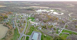
The economy of the village of La Valle is largely driven by tourism and the lake communities at nearby Lake Redstone and Dutch Hollow Lake.

2010 census

As of the census [3] of 2010, there were 367 people, 165 households, and 97 families living in the village. The population density was 873.8 inhabitants per square mile (337.4/km2). There were 172 housing units at an average density of 409.5 per square mile (158.1/km2). The racial makeup of the village was 97.5% White, 0.3% African American, 1.6% Asian, and 0.5% from two or more races. Hispanic or Latino of any race were 2.2% of the population.

There were 165 households, of which 29.1% had children under the age of 18 living with them, 39.4% were married couples living together, 12.1% had a female householder with no husband present, 7.3% had a male householder with no wife present, and 41.2% were non-families. 31.5% of all households were made up of individuals, and 14.5% had someone living alone who was 65 years of age or older. The average household size was 2.22 and the average family size was 2.78.

The median age in the village was 39.1 years. 20.4% of residents were under the age of 18; 9.1% were between the ages of 18 and 24; 27.8% were from 25 to 44; 24% were from 45 to 64; and 18.8% were 65 years of age or older. The gender makeup of the village was 51.0% male and 49.0% female.

2000 census

As of the census [5] of 2000, there were 326 people, 132 households, and 88 families living in the village. The population density was 778.8 people per square mile (299.7/km2). There were 139 housing units at an average density of 332.0 per square mile (127.8/km2). The racial makeup of the village was 97.55% White, 2.15% from other races, and 0.31% from two or more races. 2.15% of the population were Hispanic or Latino of any race.

There were 132 households, out of which 28.0% had children under the age of 18 living with them, 53.8% were married couples living together, 9.1% had a female householder with no husband present, and 32.6% were non-families. 24.2% of all households were made up of individuals, and 18.9% had someone living alone who was 65 years of age or older. The average household size was 2.47 and the average family size was 2.92.

In the village, the population was spread out, with 23.9% under the age of 18, 7.1% from 18 to 24, 31.9% from 25 to 44, 17.5% from 45 to 64, and 19.6% who were 65 years of age or older. The median age was 38 years. For every 100 females, there were 87.4 males. For every 100 females age 18 and over, there were 89.3 males.

The median income for a household in the village was $36,250, and the median income for a family was $42,000. Males had a median income of $31,953 versus $19,167 for females. The per capita income for the village was $16,823. None of the families and 3.1% of the population were living below the poverty line, including no under eighteens and 14.3% of those over 64.

Education

La Valle is served by the School District of Reedsburg, which has 4 elementary schools, 1 intermediate school, 1 middle school, and 1 high school. Ironton-La Valle Elementary School is the only school in La Valle.

Notable people

Related Research Articles

<span class="mw-page-title-main">Valle Vista, California</span> Census-designated place in California, United States

Valle Vista is a census-designated place (CDP) in Riverside County, California, United States and is located in the San Jacinto Valley. Some areas of Valle Vista are considered to be part of both unincorporated San Jacinto and Hemet but have yet to be incorporated. The population was 11,036 at the 2010 census, up from 8,356 at the 2000 census.

<span class="mw-page-title-main">La Due, Missouri</span> Inactive Village in Missouri, United States

La Due is an inactive village in Henry County, Missouri, United States. The population was 28 at the 2010 census.

<span class="mw-page-title-main">Wyndmere, North Dakota</span> City in North Dakota, United States

Wyndmere is a city in Richland County, North Dakota, United States. The population was 454 at the 2020 census. Wyndmere was founded in 1883 and named after Windermere in England. It is part of the Wahpeton, ND–MN Micropolitan Statistical Area.

<span class="mw-page-title-main">Monfort Heights East, Ohio</span> Former CDP in Ohio, United States

Monfort Heights East was a census-designated place (CDP) in Green Township, Hamilton County, Ohio, United States. The population was 3,880 at the 2000 census. For the 2010 census the area was merged into the new Monfort Heights CDP.

<span class="mw-page-title-main">Montpelier, Ohio</span> Village in Ohio, United States

Montpelier is a village in Williams County, Ohio, United States. The population was 4,072 at the 2010 census.

<span class="mw-page-title-main">Lurgan Township, Franklin County, Pennsylvania</span> Township in Pennsylvania, United States

Lurgan Township is a township in Franklin County, Pennsylvania, United States. The population was 2,207 at the 2020 census.

<span class="mw-page-title-main">Southampton Township, Franklin County, Pennsylvania</span> Township in Pennsylvania, United States

Southampton Township is a township that is located in Franklin County, Pennsylvania, United States. The population was 8,566 at the time of the 2020 census, an increase from the figure of 6,138 that was documented by the 2000 census.

<span class="mw-page-title-main">Rush Township, Northumberland County, Pennsylvania</span> Township in Pennsylvania, United States

Rush Township is a township that is located in Northumberland County, Pennsylvania, United States. The population at the time of the 2010 Census was 1,122, a decline from the figure of 1,189 that was tabulated in 2000.

<span class="mw-page-title-main">Toboyne Township, Perry County, Pennsylvania</span> Township in Pennsylvania, United States

Toboyne Township is a township in Perry County, Pennsylvania, United States. The population was 467 at the 2020 census. Big Spring State Forest Picnic Area is on the western end of Toboyne Township near Conococheague Mountain. Fowlers Hollow State Park is also in the township. It is named after Taughboyne, County Donegal, Ireland.

<span class="mw-page-title-main">East Huntingdon Township, Westmoreland County, Pennsylvania</span> Township in Pennsylvania, United States

East Huntingdon Township is a township in Westmoreland County, Pennsylvania, United States. The population was 7,712 at the 2020 census. From 1978 to 1988, the township had been home to the Volkswagen Westmoreland Assembly Plant, which later became a Sony plant. As of 2020 companies there include DNP, Cenveo, and Siemens.

<span class="mw-page-title-main">North Belle Vernon, Pennsylvania</span> Borough in Pennsylvania, United States

North Belle Vernon is a borough in Westmoreland County, Pennsylvania, United States. The population was 1,971 at the time of the 2010 census.

<span class="mw-page-title-main">Windsor, Pennsylvania</span> Borough in Pennsylvania, United States

Windsor is a borough in York County, Pennsylvania, United States. It was established in 1905 and was named after Windsor, England and was formerly named Windsorville. The population was 1,359 at the 2020 census. In the spring of 2016, the Pennsylvania Department of Conservation and Natural Resources and York County's Marcellus Shale fund provided $350,000 to make improvements at the Windsor baseball field. The project includes a handicap accessible bridge, wetland plants to capture rain runoff, new playground equipment and new bleachers.

<span class="mw-page-title-main">Windsor Township, York County, Pennsylvania</span> Township in Pennsylvania, United States

Windsor Township is a township in York County, Pennsylvania, United States. The population was 17,839 at the 2020 census.

<span class="mw-page-title-main">Decaturville, Tennessee</span> Town in Tennessee, United States

Decaturville is a town in and the county seat of Decatur County, Tennessee, United States. The population was 867 at the 2010 census. It is named for American Revolutionary War Commodore Stephen Decatur, Jr.

<span class="mw-page-title-main">Moundsville, West Virginia</span> City in West Virginia, United States

Moundsville is a city in and the county seat of Marshall County, West Virginia, United States, along the Ohio River. The population was 8,122 at the 2020 census. It is part of the Wheeling metropolitan area. The city was named for the nearby ancient Grave Creek Mound, constructed 250 to 100 BC by indigenous people of the Adena culture.

<span class="mw-page-title-main">Pineville, West Virginia</span> Town in West Virginia, United States

Pineville is a town in and the county seat of Wyoming County, West Virginia, United States, situated along the Guyandotte River. The population was 648 at the 2020 census.

<span class="mw-page-title-main">Exeter, Wisconsin</span> Town in Wisconsin, United States

Exeter is a town in Green County, Wisconsin, United States. The population was 1,261 at the 2000 census. The unincorporated communities of Dayton and Ross Crossing are located in the town.

<span class="mw-page-title-main">Lac La Belle, Wisconsin</span> Village in Wisconsin, United States

Lac La Belle is a village located mostly in Waukesha County in the U.S. state of Wisconsin. The population was 281 at the 2020 census. The village is located mostly within the town of Oconomowoc in Waukesha County. On March 28, 2002, the village annexed a portion of land in the town of Ixonia in Jefferson County.

<span class="mw-page-title-main">Ironton, Wisconsin</span> Village in Wisconsin, United States

Ironton is a village in Sauk County, Wisconsin, United States, along the Little Baraboo River. The population was 253 at the 2010 census. The village is located within the Town of Ironton.

The Town of La Valle is located in Sauk County, Wisconsin, United States. La Valle is a name derived from French meaning "the valley". The population was 1,203 at the 2000 census. The Village of La Valle is located within the town.

References

  1. "2019 U.S. Gazetteer Files". United States Census Bureau. Retrieved August 7, 2020.
  2. 1 2 "US Board on Geographic Names". United States Geological Survey. October 25, 2007. Retrieved January 31, 2008.
  3. 1 2 "U.S. Census website". United States Census Bureau . Retrieved November 18, 2012.
  4. 1 2 "Population and Housing Unit Estimates". United States Census Bureau. May 24, 2020. Retrieved May 27, 2020.
  5. 1 2 "U.S. Census website". United States Census Bureau . Retrieved January 31, 2008.
  6. "Sauk County". Jim Forte Postal History. Retrieved March 22, 2015.
  7. Chicago and North Western Railway Company (1908). A History of the Origin of the Place Names Connected with the Chicago & North Western and Chicago, St. Paul, Minneapolis & Omaha Railways. p. 93.
  8. "US Gazetteer files: 2010, 2000, and 1990". United States Census Bureau. February 12, 2011. Retrieved April 23, 2011.
  9. "US Gazetteer files 2010". United States Census Bureau. Archived from the original on July 2, 2012. Retrieved November 18, 2012.
  10. "Census of Population and Housing". Census.gov. Retrieved June 4, 2015.