The Town of La Valle is located in Sauk County, Wisconsin, United States. La Valle is a name derived from French meaning "the valley". [1] The population was 1,203 at the 2000 census. The Village of La Valle is located within the town.
The Town of La Valle is located in Sauk County, Wisconsin, United States. La Valle is a name derived from French meaning "the valley". [1] The population was 1,203 at the 2000 census. The Village of La Valle is located within the town.

According to the United States Census Bureau, the town has a total area of 35.3 square miles (91.5 km2), of which, 34.2 square miles (88.6 km2) of it is land and 1.1 square miles (2.9 km2) of it (3.20%) is water. La Valle is 3 miles from Lake Redstone.
As of the census [2] of 2000, there were 1,203 people, 450 households, and 364 families residing in the town. The population density was 35.2 people per square mile (13.6/km2). There were 914 housing units at an average density of 26.7 per square mile (10.3/km2). The racial makeup of the town was 98.75% White, 0.08% Native American, 0.08% Asian, 0.58% from other races, and 0.50% from two or more races. 0.91% of the population were Hispanic or Latino of any race.
There were 450 households, out of which 29.6% had children under the age of 18 living with them, 74.0% were married couples living together, 4.0% had a female householder with no husband present, and 18.9% were non-families. 15.3% of all households were made up of individuals, and 7.8% had someone living alone who was 65 years of age or older. The average household size was 2.67 and the average family size was 2.96.
In the town, the population was spread out, with 25.4% under the age of 18, 7.0% from 18 to 24, 22.9% from 25 to 44, 26.4% from 45 to 64, and 18.3% who were 65 years of age or older. The median age was 42 years. For every 100 females, there were 106.3 males. For every 100 females age 18 and over, there were 108.4 males.
The median income for a household in the town was $45,350, and the median income for a family was $47,500. Males had a median income of $36,442 versus $23,417 for females. The per capita income for the town was $21,561. About 1.5% of families and 3.0% of the population were below the poverty line, including 1.4% of those under age 18 and 2.4% of those age 65 or over.

Wallagrass is a town in Aroostook County, Maine, United States. The population was 519 at the 2020 census.

Wellington is a town in Piscataquis County, Maine, United States. The town was named for Arthur Wellesley, 1st Duke of Wellington. The population was 229 at the 2020 census.
Swan Creek Township is a civil township of Saginaw County in the U.S. state of Michigan. The population was 2,416 at the 2020 Census.

Sauk Centre is a city in Stearns County, Minnesota, United States. The population was 4,555 at the 2020 census. Sauk Centre is part of the St. Cloud Metropolitan Statistical Area.
Rathbone is a town in Steuben County, New York, United States. The population was 1,095 as of the 2020 census. The name comes from early settler, General Ransom Rathbone.

Bear Creek is a town in Sauk County, Wisconsin, United States. In September 1858, the town of Bear Creek was created out of the town of Franklin. The town consists of 50 sections and is bounded on the north by the town of Washington, on the south by the town of Spring Green, on the east by the town of Franklin, and on the west by Richland County. The population was 497 at the 2000 census. The town took its name from Bear Creek. The unincorporated community of Loreto is located in the town.

The Town of Excelsior is a located in Sauk County, Wisconsin, United States. The population was 1,410 at the 2000 census.
The Town of Freedom is a located in Sauk County, Wisconsin, United States. The population was 416 at the 2000 census. The unincorporated community of La Rue is located within the town. The town was named from the American ideal of freedom.
The Town of Greenfield is a located in Sauk County, Wisconsin, United States. The population was 909 at the 2020 census. The town was named after Greenfield, Massachusetts.

The Town of Sumpter is located in Sauk County, Wisconsin, United States.

The Town of Troy is located in Sauk County, Wisconsin, United States. The population was 773 at the 2000 census. The unincorporated communities of Black Hawk, Cassell, and Witwen are located in the town.

The Town of Westfield is located in Sauk County, Wisconsin, United States. The population was 611 at the 2000 census.

The Town of Woodland is located in Sauk County, Wisconsin, United States. The population was 783 at the 2000 census. The unincorporated community of Valton is located in the town.

Ixonia is a census-designated place (CDP) in the town of Ixonia, Jefferson County, Wisconsin, United States. The population was 2,367 at the 2020 census.

Ironton is a village in Sauk County, Wisconsin, United States, along the Little Baraboo River. The population was 253 at the 2010 census. The village is located within the Town of Ironton.
Ironton is a town in Sauk County, Wisconsin, United States. The population was 650 at the 2000 census. The town was named from deposits of iron ore in the area. The Village of Ironton is located within the town.
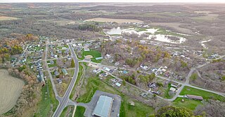
La Valle is a village in Sauk County, Wisconsin, United States, along the Baraboo River. The population was 367 at the 2010 census. The village is located within the Town of La Valle.

The Town of Prairie du Sac is located in southwestern Sauk County, Wisconsin, United States. The population was 1,138 at the 2000 census. The Village of Prairie du Sac is located within the town. The unincorporated community of Loddes Mill is also located in the town.

The Town of Spring Green is located in Sauk County, Wisconsin, United States. The January 1, 2021, final population estimate for the town is 1,728. Approximately 1,374 of the estimated population for the Town of Spring Green in Sauk County are of voting age.
Winter is a town in Sawyer County, Wisconsin, United States. The population was 969 at the 2000 census. The Village of Winter is located within the town, but not a part of it. The unincorporated community of Hay Stack Corner is also located in the town. The town claims to be the largest town in Wisconsin.
Municipalities and communities of Sauk County, Wisconsin, United States | ||
|---|---|---|
| Cities |  | |
| Villages | ||
| Towns | ||
| CDPs | ||
| Unincorporated communities | ||
| Indian reservation | ||
| Footnotes | ‡This populated place also has portions in an adjacent county or counties | |