Ironton, Wisconsin

Last updated
Ironton, Wisconsin
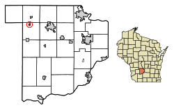
Sauk County Wisconsin Incorporated and Unincorporated areas Ironton Highlighted.svg
Location of Ironton in Sauk County, Wisconsin.
Coordinates: 43°31′17″N90°8′49″W / 43.52139°N 90.14694°W / 43.52139; -90.14694 Coordinates: 43°31′17″N90°8′49″W / 43.52139°N 90.14694°W / 43.52139; -90.14694
Country Flag of the United States.svg  United States
State Flag of Wisconsin.svg  Wisconsin
County Sauk
Area
[1]
  Total0.33 sq mi (0.87 km2)
  Land0.33 sq mi (0.86 km2)
  Water0.00 sq mi (0.00 km2)
Elevation
[2]
1,079 ft (329 m)
Population
 (2010) [3]
  Total253
  Estimate 
(2019) [4]
252
  Density756.76/sq mi (292.14/km2)
Time zone UTC-6 (Central (CST))
  Summer (DST) UTC-5 (CDT)
Area code(s) 608
FIPS code 55-37250 [5]
GNIS feature ID1566977 [2]

Ironton is a village in Sauk County, Wisconsin, United States, along the Little Baraboo River. The population was 253 at the 2010 census. The village is located within the Town of Ironton.

Contents

Like the Town of Ironton, the village was named for deposits of iron ore in the area. [6]

Geography

Ironton is located at 43°32′41″N90°8′25″W / 43.54472°N 90.14028°W / 43.54472; -90.14028 (43.544725, -90.140442). [7]

According to the United States Census Bureau, the village has a total area of 0.33 square miles (0.85 km2), all of it land. [8]

Demographics

Historical population
CensusPop.
1880 232
1890 2372.2%
1920 199
1930 184−7.5%
1940 21315.8%
1950 176−17.4%
1960 167−5.1%
1970 19516.8%
1980 2065.6%
1990 200−2.9%
2000 25025.0%
2010 2531.2%
2019 (est.)252 [4] −0.4%
U.S. Decennial Census [9]

2010 census

As of the census [3] of 2010, there were 253 people, 92 households, and 69 families living in the village. The population density was 766.7 inhabitants per square mile (296.0/km2). There were 104 housing units at an average density of 315.2 per square mile (121.7/km2). The racial makeup of the village was 95.7% White, 0.4% African American, and 4.0% from two or more races. Hispanic or Latino of any race were 1.6% of the population.

There were 92 households, of which 40.2% had children under the age of 18 living with them, 51.1% were married couples living together, 12.0% had a female householder with no husband present, 12.0% had a male householder with no wife present, and 25.0% were non-families. 16.3% of all households were made up of individuals, and 4.4% had someone living alone who was 65 years of age or older. The average household size was 2.75 and the average family size was 3.06.

The median age in the village was 30.4 years. 28.1% of residents were under the age of 18; 11.8% were between the ages of 18 and 24; 26.1% were from 25 to 44; 24.1% were from 45 to 64; and 9.9% were 65 years of age or older. The gender makeup of the village was 53.4% male and 46.6% female.

2000 census

As of the census [5] of 2000, there were 250 people, 89 households, and 66 families living in the village. The population density was 743.6 people per square mile (283.9/km2). There were 99 housing units at an average density of 294.5 per square mile (112.4/km2). The racial makeup of the village was 97.60% White and 2.40% Black or African American. 1.60% of the population were Hispanic or Latino of any race.

There were 89 households, out of which 40.4% had children under the age of 18 living with them, 59.6% were married couples living together, 6.7% had a female householder with no husband present, and 25.8% were non-families. 18.0% of all households were made up of individuals, and 6.7% had someone living alone who was 65 years of age or older. The average household size was 2.81 and the average family size was 3.21.

In the village, the population was spread out, with 32.0% under the age of 18, 6.8% from 18 to 24, 33.2% from 25 to 44, 16.4% from 45 to 64, and 11.6% who were 65 years of age or older. The median age was 32 years. For every 100 females, there were 103.3 males. For every 100 females age 18 and over, there were 109.9 males.

The median income for a household in the village was $38,438, and the median income for a family was $41,250. Males had a median income of $31,875 versus $22,292 for females. The per capita income for the village was $13,874. About 15.2% of families and 10.8% of the population were below the poverty line, including 11.4% of those under the age of eighteen and 31.8% of those 65 or over.

Education

Ironton is served by the School District of Reedsburg, which has 4 elementary schools, 1 intermediate school, 1 middle school, and 1 high school. Ironton-La Valle Elementary School is the closest school to Ironton, being located in La Valle, Wisconsin.

Notable people

Related Research Articles

Sherwood, Wisconsin Village in Wisconsin, United States

Sherwood is a village in Calumet County, Wisconsin, United States. The population was 2,713 at the 2010 census. The former historical unincorporated community of High Cliff is located within present-day Sherwood.

Poynette, Wisconsin Village in Wisconsin, United States

Poynette is a village in Columbia County, Wisconsin, United States. The population was 2,590 at the 2020 census. It is part of the Madison Metropolitan Statistical Area.

Mount Sterling, Wisconsin Village in Wisconsin, United States

Mount Sterling is a village in Crawford County, Wisconsin, United States. The population was 211 at the 2010 census.

Cleveland (village), Wisconsin Village in Wisconsin, United States

Cleveland is a village in Manitowoc County, Wisconsin, United States. The population was 1,485 at the 2010 census.

Kendall, Monroe County, Wisconsin Village in Wisconsin, United States

Kendall is a village in Monroe County, Wisconsin, United States, along the Baraboo River. The population was 472 at the 2010 census.

Junction City, Wisconsin Village in Wisconsin, United States

Junction City is a village in Portage County, Wisconsin, United States. The population was 439 at the 2010 census.

Lake Delton, Wisconsin Village in Wisconsin, United States

Lake Delton is a village located on the Wisconsin River in Sauk County, Wisconsin, United States. The population was 2,914 at the 2010 census. It also makes it the largest community in the Dells area passing the Wisconsin Dells. Lake Delton, along with the nearby Wisconsin Dells, is a resort area and a major center for tourism.

North Freedom, Wisconsin Village in Wisconsin, United States

North Freedom is a village along the Baraboo River in Sauk County, Wisconsin, United States. The population was 701 at the 2010 census.

Rock Springs, Wisconsin Village in Wisconsin, United States

Rock Springs is a village in Sauk County, Wisconsin, United States, along the Baraboo River. The population was 362 at the 2010 census.

West Baraboo, Wisconsin Village in Wisconsin, United States

West Baraboo is a village along the Baraboo River in Sauk County, Wisconsin, United States. The population was 1,414 at the 2010 census. It is part of the Baraboo micropolitan statistical area.

Marquette, Wisconsin Village in Wisconsin, United States

Marquette is a village in Green Lake County, Wisconsin, United States. The population was 150 at the 2010 census. The village is located within the Town of Marquette. Marquette uses the postal code 53947.

Highland, Wisconsin Village in Wisconsin, United States

Highland is a village in Iowa County, Wisconsin, United States. The population was 842 at the 2010 census. It is part of the Madison Metropolitan Statistical Area. The village is located within the Town of Highland.

Wonewoc, Wisconsin Village in Wisconsin, United States

Wonewoc is a village along the Baraboo River in Juneau County, Wisconsin, United States. The population was 816 at the 2010 census.

Spencer, Wisconsin Village in Wisconsin, United States

Spencer is a village in Marathon County, Wisconsin. It is part of the Wausau, Wisconsin Metropolitan Statistical Area. The population was 1,925 at the 2010 census.

Baraboo (town), Wisconsin Town in Wisconsin, United States

Baraboo is a town in Sauk County, Wisconsin, United States. The population was 1,816 at the 2020 census. The City of Baraboo is located mostly within the town. The unincorporated community of Crawford Crossing is located in the town.

Baraboo, Wisconsin City in Wisconsin, United States

Baraboo is a city in and the county seat of Sauk County, Wisconsin, United States. The largest city in the county, Baraboo is the principal city of the Baraboo Micropolitan Statistical Area. Its 2020 population was 12,556. It is situated on the Baraboo River.

Ironton is a town in Sauk County, Wisconsin, United States. The population was 650 at the 2000 census. The town was named from deposits of iron ore in the area. The Village of Ironton is located within the town.

La Valle, Wisconsin Village in Wisconsin, United States

La Valle is a village in Sauk County, Wisconsin, United States, along the Baraboo River. The population was 367 at the 2010 census. The village is located within the Town of La Valle.

Aniwa, Wisconsin Village in Wisconsin, United States

Aniwa is a village in Shawano County, Wisconsin, United States. The population was 260 at the 2010 census. The village is located within the Town of Aniwa. U.S. Route 45 runs north–south through the village.

Auburndale, Wisconsin Village in Wisconsin, United States

Auburndale is a village in Wood County, Wisconsin, United States. The population was 703 at the 2010 census.

References

  1. "2019 U.S. Gazetteer Files". United States Census Bureau. Retrieved August 7, 2020.
  2. 1 2 "US Board on Geographic Names". United States Geological Survey. 2007-10-25. Retrieved 2008-01-31.
  3. 1 2 "U.S. Census website". United States Census Bureau . Retrieved 2012-11-18.
  4. 1 2 "Population and Housing Unit Estimates". United States Census Bureau. May 24, 2020. Retrieved May 27, 2020.
  5. 1 2 "U.S. Census website". United States Census Bureau . Retrieved 2008-01-31.
  6. Cole, Henry Ellsworth (1912). Baraboo and Other Place Names in Sauk County, Wisconsin. Baraboo News Publishing Company. p.  30.
  7. "US Gazetteer files: 2010, 2000, and 1990". United States Census Bureau. 2011-02-12. Retrieved 2011-04-23.
  8. "US Gazetteer files 2010". United States Census Bureau. Archived from the original on 2012-01-25. Retrieved 2012-11-18.
  9. "Census of Population and Housing". Census.gov. Retrieved June 4, 2015.