Chippewa is a town in Ashland County in the U.S. state of Wisconsin. The population was 374 at the 2010 census.
Canton is a town in Buffalo County in the U.S. state of Wisconsin. The population was 305 at the 2010 census. The ghost town of Springdale was located in the town.

Webster is a village in Burnett County in the U.S. state of Wisconsin. The population was 653 at the 2010 census. It is along Wisconsin Highway 35.

Auburn is a town in Chippewa County in the U.S. state of Wisconsin. The population was 697 at the 2010 census, up from 580 at the 2000 census.

Cleveland is a town in Chippewa County, Wisconsin, United States. The population was 864 at the 2010 census.
Cooks Valley is a town in Chippewa County in the U.S. state of Wisconsin. The population was 805 at the 2010 census, up from 632 at the 2000 census. The town was named after Jacob Cook, who purchased property in the valley in the summer of 1858. A post office was established in 1870 with William Miller as the first postmaster.

The Town of Delmar is located in Chippewa County in the U.S. state of Wisconsin. The population was 936 at the 2010 census.
The Town of Estella is located in Chippewa County in the U.S. state of Wisconsin. The population was 433 at the 2010 census.

The Town of Howard is located in southwestern Chippewa County in the U.S. state of Wisconsin. The population was 798 at the 2010 census, up from 648 at the 2000 census. The unincorporated communities of Albertville and Howard are located in the town.

Lake Holcombe is a town in Chippewa County in the U.S. state of Wisconsin. Its population was 1,031 at the 2010 census. The census-designated place of Holcombe is located in the town.

Sigel is a town in Chippewa County in the U.S. state of Wisconsin. The population was 1,044 at the 2010 census, up from 825 at the 2000 census.

The Town of Tilden is located in Chippewa County in the U.S. state of Wisconsin. The population was 1,485 at the 2010 census, up from 1,185 at the 2000 census.

The Town of Eau Galle is located in Dunn County, Wisconsin, United States. The population was 797 at the 2000 census. The unincorporated community of Eau Galle and the ghost town of Welch Point are located in the town.
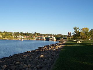
Prescott is a city in Pierce County, Wisconsin at the confluence of the St. Croix River and Mississippi River. The population was 4,258 at the 2010 census, making it the second-largest city in the county after River Falls, and the largest entirely within Pierce County.

Nelson is a village in Buffalo County in the U.S. state of Wisconsin. The population was 374 at the 2010 census. The village is surrounded by the Town of Nelson.
Nelson is a town in Buffalo County in the U.S. state of Wisconsin. The population was 571 at the 2010 census. The village of Nelson is located within the town. The unincorporated community of Misha Mokwa and railroad junction Trevino are located in the town. The unincorporated community of Urne is located partially in the town.

Maiden Rock is a village in Pierce County, Wisconsin, United States. The population was 119 at the 2010 census. The village is located within the Town of Maiden Rock.
Balsam Lake is a village in, and the county seat of Polk County, Wisconsin, United States. The population was 1,009 at the 2010 census. The village is located within the Town of Balsam Lake.

Aniwa is a village in Shawano County, Wisconsin, United States. The population was 260 at the 2010 census. The village is located within the Town of Aniwa. U.S. Route 45 runs north–south through the village.

Walworth is a village in Walworth County, Wisconsin, United States. The population was 2,759 at the 2020 census. The village is located within the Town of Walworth.