Modena, Wisconsin

Last updated
Modena, Wisconsin
WIMap-doton-Modena.png
Location of Modena, Wisconsin
Coordinates: 44°27′32″N91°49′29″W / 44.45889°N 91.82472°W / 44.45889; -91.82472
Country Flag of the United States.svg  United States
State Flag of Wisconsin.svg  Wisconsin
County Buffalo
Area
  Total36.1 sq mi (93.4 km2)
  Land35.9 sq mi (93.0 km2)
  Water0.2 sq mi (0.4 km2)
Elevation
[1]
827 ft (252 m)
Population
 (2010)
  Total354
  Density10/sq mi (3.8/km2)
Time zone UTC-6 (Central (CST))
  Summer (DST) UTC-5 (CDT)
FIPS code 55-53450 [2]
GNIS feature ID1583733 [1]

Modena is a town in Buffalo County in the U.S. state of Wisconsin. The population was 354 at the 2010 census. [3] The unincorporated community of Urne is also located partially in the town.

Contents

Geography

According to the United States Census Bureau, the town has a total area of 36.1 square miles (93.4 km2), of which 35.9 square miles (93.0 km2) is land and 0.15 square miles (0.4 km2), or 0.47%, is water. [3]

Demographics

As of the census [2] of 2000, there were 318 people, 134 households, and 90 families residing in the town. The population density was 8.8 people per square mile (3.4/km2). There were 155 housing units at an average density of 4.3 per square mile (1.7/km2). The racial makeup of the town was 99.69% White and 0.31% African American. Hispanic or Latino of any race were 0.31% of the population.

There were 134 households, out of which 28.4% had children under the age of 18 living with them, 59.0% were married couples living together, 6.0% had a female householder with no husband present, and 32.8% were non-families. 28.4% of all households were made up of individuals, and 10.4% had someone living alone who was 65 years of age or older. The average household size was 2.37 and the average family size was 2.96.

In the town, the population was spread out, with 23.9% under the age of 18, 6.3% from 18 to 24, 28.0% from 25 to 44, 27.0% from 45 to 64, and 14.8% who were 65 years of age or older. The median age was 41 years. For every 100 females, there were 106.5 males. For every 100 females age 18 and over, there were 110.4 males.

The median income for a household in the town was $35,000, and the median income for a family was $45,893. Males had a median income of $27,303 versus $23,750 for females. The per capita income for the town was $16,142. About 5.0% of families and 5.0% of the population were below the poverty line, including 2.2% of those under age 18 and 12.7% of those age 65 or over.

Notable people

Related Research Articles

<span class="mw-page-title-main">Richgrove, California</span> Census-designated place in California, United States

Richgrove is a census-designated place (CDP) in Tulare County, California, United States. The population was 2,882 at the 2010 census, up from 2,723 at the 2000 census.

<span class="mw-page-title-main">Hammond, Maine</span> Town in the state of Maine, United States

Hammond is a town in Aroostook County, Maine, United States. The population was 91 at the 2020 census.

<span class="mw-page-title-main">Cumberland Center, Maine</span> Census-designated place in Maine, United States

Cumberland Center is a census-designated place (CDP) within the town of Cumberland in Cumberland County, Maine, United States. The population was 2,499 at the 2010 census. It is part of the Portland – South Portland – Biddeford, Maine, Metropolitan Statistical Area.

Osborn is a town in Hancock County, Maine, United States. The population was 65 at the 2020 census.

Roque Bluffs is a town in Washington County, Maine, United States. The population was 296 at the 2020 census. The town is home to Roque Bluffs State Park.

Wabanica Township is a township in Lake of the Woods County, Minnesota, United States. The population was 291 at the 2000 census.

<span class="mw-page-title-main">Saco, Montana</span> Town in Montana, United States

Saco is a town in Phillips County, Montana, United States. The population was 159 at the 2020 census.

<span class="mw-page-title-main">Santa Clara, New York</span> Town in New York, United States

Santa Clara is a town in Franklin County, New York, United States. The population was 345 at the 2010 census. The name was derived from the wife of an early town businessman, John Hurd.

<span class="mw-page-title-main">Modena, Pennsylvania</span> Borough in Pennsylvania, United States

Modena is a borough in Chester County, Pennsylvania, United States. The population was 544 at the 2020 census. It was originally called Modeville, after the local Mode family.

<span class="mw-page-title-main">Putnam Township, Tioga County, Pennsylvania</span> Township in Pennsylvania, United States

Putnam Township is a township in Tioga County, Pennsylvania, United States. The population was 401 at the 2020 census. Putnam Township is the village of Covington. Covington was formerly a borough that chose to become a township in 1892. It was settled in 1801.

<span class="mw-page-title-main">Gary, South Dakota</span> City in South Dakota, United States

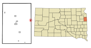
Gary is a city in Deuel County, South Dakota, United States. The population was 240 at the 2020 census. South Dakota Highway 101 serves as the main route of the community.

<span class="mw-page-title-main">Anawalt, West Virginia</span> Town in West Virginia, United States

Anawalt is a town in McDowell County, West Virginia, United States. At one time it was known as Jeanette. It is named in honor of James White Anawalt, who was then manager of Union Supply Company, a subsidiary of the United States Steel Company. The population was 186 at the 2020 census. Coal mining was the town's chief industry.

<span class="mw-page-title-main">Glencoe, Wisconsin</span> Town in Wisconsin, United States

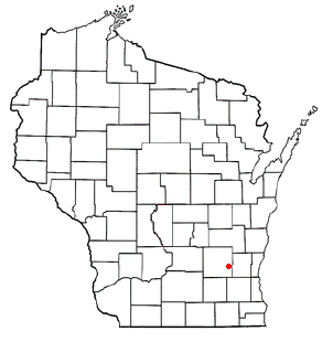
Glencoe is a town in Buffalo County in the U.S. state of Wisconsin. The population was 485 at the 2010 census. The unincorporated community of Glencoe is located in the town.

<span class="mw-page-title-main">Elba, Wisconsin</span> Town in Wisconsin, United States

Elba is a town in Dodge County, Wisconsin, United States. The population was 1,086 at the 2000 census. The unincorporated communities of Astico and Danville are located in the town.

<span class="mw-page-title-main">Rubicon, Wisconsin</span> Town in Wisconsin, United States

Rubicon is a town in Dodge County, Wisconsin, United States. The population was 2,005 at the 2000 census. The unincorporated communities of Rubicon and Saylesville are located in the town. The unincorporated community of Woodland is also located partially in the town.

<span class="mw-page-title-main">North Bend, Wisconsin</span> Town in Wisconsin, United States

North Bend is a town in Jackson County, Wisconsin, United States. The population was 397 at the 2000 census. The unincorporated communities of Buckholz Corners and North Bend are located in the town.

<span class="mw-page-title-main">Hale, Wisconsin</span> Town in Wisconsin, United States

Hale is a town in Trempealeau County, Wisconsin, United States. The population was 988 at the 2000 census. The unincorporated communities of Elk Creek, Hale, and Pleasantville are located in the town.

Trempealeau is a town in Trempealeau County, Wisconsin, United States. The population was 1,618 at the 2000 census. The town surrounds the village of Trempealeau. The unincorporated communities of Centerville, West Prairie, and Wrights Corners are in the town.

Birchwood is a town in Washburn County, Wisconsin, United States. The population was 453 at the 2000 census. The Village of Birchwood is located within the town.

<span class="mw-page-title-main">Plattekill (town), New York</span> Place in New York, United States

Plattekill is a town in Ulster County, New York, United States. The population was 10,424 in 2020, a slight decrease from 10,499 at the 2010 census. The name is derived from a stream, the Platte Kill.

References

  1. 1 2 "US Board on Geographic Names". United States Geological Survey. 2007-10-25. Retrieved 2008-01-31.
  2. 1 2 "U.S. Census website". United States Census Bureau . Retrieved 2008-01-31.
  3. 1 2 "Geographic Identifiers: 2010 Demographic Profile Data (G001): Modena town, Buffalo County, Wisconsin". U.S. Census Bureau, American Factfinder. Archived from the original on February 12, 2020. Retrieved May 21, 2014.

Coordinates: 44°27′27″N91°47′48″W / 44.45750°N 91.79667°W / 44.45750; -91.79667