Cooperstown, Wisconsin

Last updated

Cooperstown, Wisconsin
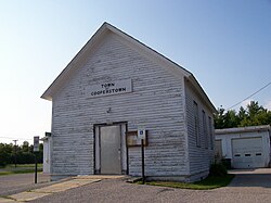
CooperstownWisconsinTownHall.jpg
Town Hall
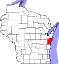
WIMap-doton-Cooperstown.png
Location of Cooperstown, Wisconsin
Coordinates: 44°17′1″N87°49′10″W / 44.28361°N 87.81944°W / 44.28361; -87.81944
Country Flag of the United States.svg  United States
State Flag of Wisconsin.svg  Wisconsin
County Manitowoc
Area
  Total35.1 sq mi (91.0 km2)
  Land35.1 sq mi (90.9 km2)
  Water0.0 sq mi (0.1 km2)
Elevation
[1]
896 ft (273 m)
Population
 (2000)
  Total1,403
  Density40.0/sq mi (15.4/km2)
Time zone UTC-6 (Central (CST))
  Summer (DST) UTC-5 (CDT)
Area code 920
FIPS code 55-16950 [2]
GNIS feature ID1583015 [1]
Website townofcooperstown.com

Cooperstown is a town in Manitowoc County, Wisconsin, in the United States. As of the 2000 census, the town population was 1,403.

Contents

Communities

Geography

According to the United States Census Bureau, the town has a total area of 35.1 square miles (91.0 km2), of which, 35.1 square miles (91.0 km2) of it is land and 0.04 square miles (0.1 km2) of it (0.09%) is water.

Demographics

As of the census [2] of 2000, there were 1,403 people, 474 households, and 401 families residing in the town. The population density was 40.0 people per square mile (15.4/km2). There were 489 housing units at an average density of 13.9 per square mile (5.4/km2). The racial makeup of the town was 98.29% White, 0.50% Native American, 0.57% Asian, 0.21% from other races, and 0.43% from two or more races. Hispanic or Latino of any race were 0.64% of the population.

There were 474 households, out of which 42.4% had children under the age of 18 living with them, 77.0% were married couples living together, 4.6% had a female householder with no husband present, and 15.4% were non-families. 12.0% of all households were made up of individuals, and 4.9% had someone living alone who was 65 years of age or older. The average household size was 2.96 and the average family size was 3.21.

In the town, the population was spread out, with 29.7% under the age of 18, 6.3% from 18 to 24, 30.1% from 25 to 44, 26.3% from 45 to 64, and 7.6% who were 65 years of age or older. The median age was 37 years. For every 100 females, there were 111.0 males. For every 100 females age 18 and over, there were 112.0 males.

The median income for a household in the town was $58,177, and the median income for a family was $60,385. Males had a median income of $40,048 versus $23,750 for females. The per capita income for the town was $20,941. About 2.4% of families and 3.8% of the population were below the poverty line, including 4.7% of those under age 18 and 2.0% of those age 65 or over.

Points of Interest

Related Research Articles

<span class="mw-page-title-main">Howey-in-the-Hills, Florida</span> Town in the state of Florida, United States

Howey-In-The-Hills is a town in Lake County, Florida, United States. The population was 1,098 at the 2010 census and an estimated 1,175 in 2018. It is part of the Orlando–Kissimmee–Sanford Metropolitan Statistical Area.

<span class="mw-page-title-main">Maynard, Iowa</span> City in Iowa, United States

Maynard is a city in Fayette County, Iowa, United States. The population was 476 at the time of the 2020 census.

Grand Lake Stream is a plantation in Washington County, Maine, United States. The population was 125 at the 2020 census.

<span class="mw-page-title-main">Roscommon Township, Michigan</span> Civil township in Michigan, United States

Roscommon Township is a civil township of Roscommon County in the U.S. state of Michigan. The population was 4,411 at the 2010 census.

<span class="mw-page-title-main">Plato, Minnesota</span> City in Minnesota, United States

Plato is a city in eastern McLeod County, Minnesota, United States. The population was 320 at the 2010 census.

<span class="mw-page-title-main">Middlefield, New York</span> Town in New York, United States

Middlefield is a town in Otsego County, New York, United States. The population was 2,114 at the 2010 census.

<span class="mw-page-title-main">Otsego, New York</span> Town in New York, United States

Otsego is a town in the north-central part of Otsego County, New York, United States. The population was 3,900 at the 2010 census. The town is named after Lake Otsego, which forms part of the town's eastern border.

Catharine is a town in Schuyler County, New York, United States. The population was 1,656 at the 2020 census. The town is one of two in the county named after Catherine Montour, a Native American interpreter and leader in the area. The Town of Catharine is in the southeastern part of the county and is north of Elmira.

<span class="mw-page-title-main">De Kalb, New York</span> Town in New York, United States

DeKalb is a town in St. Lawrence County, New York, United States. The population was 2,434 at the 2010 census. The town is named after American general Baron de Kalb, a German officer serving under George Washington.

<span class="mw-page-title-main">Cooperstown, North Dakota</span> City in North Dakota, United States

Cooperstown is a city in Griggs County, North Dakota, United States. It is the county seat of Griggs County. The population was 983 at the 2020 census. Cooperstown was founded in 1882.

<span class="mw-page-title-main">Mount Pleasant Township, Washington County, Pennsylvania</span> Township in Pennsylvania, United States

Mount Pleasant Township is a township in Washington County, Pennsylvania, United States. As of the 2020 census, the township population was 3,282.

<span class="mw-page-title-main">Glenmore, Wisconsin</span> Town in Wisconsin, United States

Glenmore is a town in Brown County in the U.S. state of Wisconsin. The population was 1,135 at the 2010 census.

<span class="mw-page-title-main">Morrison, Wisconsin</span> Town in Wisconsin, United States

Morrison is a town in Brown County in the U.S. state of Wisconsin. The population was 1,599 at the 2010 census.

<span class="mw-page-title-main">Pittsfield, Wisconsin</span> Town in Wisconsin, United States

Pittsfield is a town in Brown County in the U.S. state of Wisconsin. The population was 2,608 at the 2010 census.

<span class="mw-page-title-main">Cato, Wisconsin</span> Town in Wisconsin, United States

Cato is a town in Manitowoc County, Wisconsin, United States. The population was 1,616 at the 2000 census. A Manitowoc County park is located in the town which is called "Cato Falls" for a waterfall on the Manitowoc River.

<span class="mw-page-title-main">Franklin, Manitowoc County, Wisconsin</span> Town in Wisconsin, United States

Franklin is a town in Manitowoc County, Wisconsin, United States. The population was 1,293 at the 2000 census.

<span class="mw-page-title-main">Gibson, Wisconsin</span> Town in Wisconsin, United States

Gibson is a town in Manitowoc County, Wisconsin, United States. The population was 1,352 at the 2000 census.

<span class="mw-page-title-main">Maribel, Wisconsin</span> Village in Wisconsin, United States

Maribel is a village in Manitowoc County, Wisconsin, United States. The population was 351 at the 2010 census.

Mud Hen Lake is an unorganized territory in Saint Louis County, Minnesota, United States. The population was 320 at the 2000 census.

<span class="mw-page-title-main">Clyman, Wisconsin</span> Village in Wisconsin, United States

Clyman is a village in Dodge County, Wisconsin, United States. The population was 422 at the 2010 census. The village is located within the Town of Clyman.

References

  1. 1 2 "US Board on Geographic Names". United States Geological Survey. October 25, 2007. Retrieved January 31, 2008.
  2. 1 2 "U.S. Census website". United States Census Bureau . Retrieved January 31, 2008.

44°18′46″N87°46′28″W / 44.31278°N 87.77444°W / 44.31278; -87.77444