
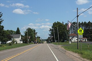
Collins is an unincorporated census-designated place in the town of Rockland, Manitowoc County, Wisconsin, United States, in the east central part of the state. Its zip code is 54207, although its post office is being studied for closure. As of the 2010 census, its population is 164. The Collins Marsh Wildlife Area is located east of the community. Wisconsin Highway 32 ran through the community; the route later became Wisconsin Highway 67 before it became County Highway W. County Highway JJ and the Wisconsin Central Ltd. railroad runs east–west through the community. Collins has an area of 0.496 square miles (1.28 km2), all of it land. The community was named for Sumner J. Collins, who was the general superintendent of the Wisconsin Central Railroad in the 1890s.

Pickerel is an unincorporated community in the northeast corner of Langlade County, Wisconsin, United States. The community is located on Wisconsin Highway 55, in the Town of Langlade. Pickerel is 19 miles (31 km) northeast of Antigo, the county seat of Langlade County. Pickerel has a post office with ZIP code 54465. The community has a volunteer fire department, which also serves the Town of Ainsworth and part of the Town of Nashville in Forest County.

Peebles, Wisconsin is an unincorporated community in the Town of Taycheedah in Fond du Lac County, Wisconsin. The community is located adjacent to the unincorporated community of Taycheedah. U.S. Route 151 runs through the community. Wisconsin Highway 149 used to run through the community at its western terminus until it was decommissioned in 2006. Taycheedah Correctional Institution is located in the town of Taycheedah several miles south of the community.
Valmy is a small unincorporated community located, in the town of Sevastopol, where WIS 57 splits with County Highway T in Door County, Wisconsin. The community serves as a gateway to the nearby Whitefish Dunes State Park as well as Cave Point County Park.
Phlox is an unincorporated community in the Town of Norwood, Langlade County, Wisconsin, United States. It is situated on Wisconsin Highway 47 southeast of Antigo. Phlox has a post office with ZIP code 54464. In the Menominee language it is called Omāhkahkow-Menīkān which means "frog town". It lies within ancestral Menominee territory which was ceded to the United States in the 1836 Treaty of the Cedars.

Garnet, Wisconsin is an unincorporated community in Fond du Lac County, in the U.S. state of Wisconsin. The community is on the north boundary of the county, just south of Calumet County. It is located at the intersection of County Highway HHH and Town Hall Road just east of Calumet County C, in the town of Calumet. Garnet is located 1.95 miles (3.14 km) east of Calumetville.

Jericho is an unincorporated community in the town of Brothertown in Calumet County, Wisconsin, United States. Jericho is located at the intersection of County highways C & H. Jericho is part of the Holyland region in Wisconsin.

Woodland is an unincorporated community located, in the town of Rubicon, in Dodge County, Wisconsin, United States. It is located at the intersection of Wisconsin Highway 67 and County highway WS.

Greenville is an unincorporated community located in the Town of Greenville, in Outagamie County, Wisconsin, United States. Greenville is located at the intersection of Wisconsin Highway 76 and Wisconsin Highway 15.

Knowles is an unincorporated community in Dodge County, Wisconsin, United States. The community is located at the intersection of County Y and County AY, in the town of Lomira.

LeRoy is an unincorporated community in the town of LeRoy in Dodge County, Wisconsin, United States. It is located at the intersection of County Y and County YY several miles west of Knowles.

Brussels is an unincorporated community located, in the town of Brussels, in Door County, Wisconsin, United States. Brussels is 14 miles (23 km) southwest of Sturgeon Bay. Brussels uses the ZIP code of 54204.
Freedom is an unincorporated community located in the town of Freedom, Outagamie County, Wisconsin, United States. Freedom is located along Wisconsin Highway 55 7.5 miles (12.1 km) north of Kaukauna. Freedom has a post office, located in Kaukauna, which uses ZIP code 54131.

Waucousta is an unincorporated community in the town of Osceola, in Fond du Lac County, Wisconsin, United States. Waucousta is located at the junction of U.S. Route 45 and County Highway F, 4 miles (6.4 km) north-northeast of Campbellsport. A branch of the Milwaukee River runs through the community.
Taus is an unincorporated community located in the town of Franklin, Manitowoc County, Wisconsin, United States.
Louis Corners is an unincorporated community located in the town of Schleswig, Manitowoc County, Wisconsin, United States. Wisconsin Highway 149 ran through the community before it was decommissioned.

Rogersville is an unincorporated community located in the town of Lamartine, Fond du Lac County, Wisconsin, United States.

Brockway is an unincorporated community located in the town of Brockway, Jackson County, Wisconsin, United States. It is located at the intersection of U.S. Route 12 and Wisconsin Highway 27 and shares its northern border with Black River Falls, Wisconsin.

La Grange is an unincorporated community located in the town of La Grange, Walworth County, Wisconsin, United States. La Grange is located on U.S. Route 12.
Spring Prairie is an unincorporated community located in the town of Spring Prairie, Walworth County, Wisconsin, United States. Spring Prairie is located at the intersection of Wisconsin Highway 11 and Wisconsin Highway 120 7.25 miles (11.67 km) east of Elkhorn.


