
Patoka is a village in Marion County, Illinois, United States. The population was 525 at the 2020 census.
Cambria is a village in northwestern Williamson County, Illinois, United States. The population was 1,228 at the 2010 census.
Island Falls is a town in Aroostook County, Maine, United States. The population was 758 at the 2020 census. The primary village of Island Falls in the town is situated at a falls in the West Branch Mattawamkeag River.

Tustin is a village in Osceola County of the U.S. state of Michigan. The population was 270 at the 2020 census. The village is within Burdell Township.
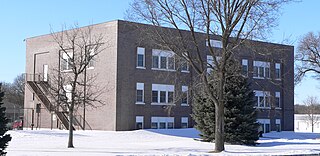
Center is a village in, and county seat of, Knox County, Nebraska, United States. The population was 73 at the 2020 census.

Uniopolis is an unincorporated community and former village in Auglaize County, Ohio, United States. The population was 188 at the 2020 census. It is included in the Wapakoneta, Ohio Micropolitan Statistical Area.

Meyers Lake is a village in central Stark County, Ohio, United States. The population was 724 at the 2020 census. It is part of the Canton–Massillon metropolitan area.

Emsworth is a borough in Allegheny County, Pennsylvania, United States, along the Ohio River. The population was 2,525 at the 2020 census.

Auburn is a town in Ritchie County, West Virginia, United States. The population was 80 at the 2020 census.

Kekoskee is a village in Dodge County, Wisconsin, United States. The population was 161 at the 2010 census.

Combined Locks is a village in Outagamie County, Wisconsin, United States. The population was 3,328 at the 2010 census.

Cecil is a village in Shawano County, Wisconsin, United States. The population was 529 at the 2020 census.

Potter Lake is a census-designated place (CDP) in the town of East Troy, Walworth County, Wisconsin, United States. The population was 1,117 at the 2020 census.

Elm Grove is a village in Waukesha County, Wisconsin, United States. The population was 6,524 at the 2020 census. Elm Grove was named as America's best suburb by Business Insider in October 2014.

Pulaski is a village in Brown, Oconto, and Shawano counties in the U.S. state of Wisconsin. The population was 3,539 at the 2010 census. Of this, 3,321 were in Brown County, 218 in Shawano County, and none in Oconto County.

Clyman is a village in Dodge County, Wisconsin, United States. The population was 422 at the 2010 census. The village is located within the Town of Clyman.

Hustisford is a village in Dodge County, Wisconsin, United States. The population was 1,101 at the 2020 census. The village is located within the town of Hustisford.

Lowell is a village in Dodge County, Wisconsin, United States, along the Beaver Dam River. The population was 340 at the 2010 census. The village is located within the Town of Lowell.

Patch Grove is a village in Grant County, Wisconsin, United States. The population was 198 at the 2010 census. The village is located within the Town of Patch Grove.

East Troy is a Village in Walworth County, Wisconsin, United States. The population was 5,673 at the 2020 census. The Village is located southwest of the Town of East Troy. A small portion extends into the adjacent Town of Troy. As of 2020, the Village of East Troy has become a rapid growing community in housing and businesses.


