
Holland is a town in Brown County in the U.S. state of Wisconsin. The population was 1,519 at the 2010 census. The unincorporated communities of Askeaton and Hollandtown are located in the town.
Potter is a village in Calumet County in the U.S. state of Wisconsin. The population was 253 at the 2010 census.

Sherwood is a village in Calumet County, Wisconsin, United States. The population was 2,713 at the 2010 census. The former historical unincorporated community of High Cliff is located within present-day Sherwood.

Woodville is a town in Calumet County in the U.S. state of Wisconsin. The population was 980 at the 2010 census. The unincorporated communities of Dundas and St. John are located in the community.
Tiffany is a town in Dunn County, Wisconsin, United States. The population was 617 at the time of the 2020 census. The villages of Boyceville and Downing are adjacent to the town.
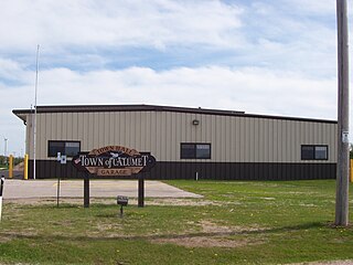
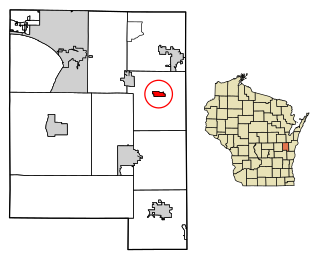
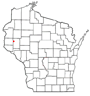
Calumet is a town in Fond du Lac County, Wisconsin, United States. The population was 1,514 at the 2000 census. The unincorporated communities of Artesia Beach, Calumet Harbor, Garnet, Highland Park, Johnsburg, Laudolff Beach, Marytown, Pipe, Pukwana Beach, Winnebago Heights, and Winnebago Park are located within the town. The unincorporated community of Calumetville is located partially in the town.

Marshfield is a town in Fond du Lac County, Wisconsin, United States. The population was 1,118 at the 2000 census. The unincorporated communities of Calvary and St. Joe are located in the town. The unincorporated community of Malone is also located partially in the town.

Middle Inlet is a town in Marinette County, Wisconsin, United States. The population was 831 at the 2000 census.

Bonduel is a village in Shawano County, Wisconsin, United States. The population was 1,478 at the 2010 census.

Brillion is a town in Calumet County in the U.S. state of Wisconsin. The population was 1,486 at the 2010 census.

Chilton is a town in Calumet County in the U.S. state of Wisconsin. The population was 1,143 at the 2010 census. The City of Chilton is located partially within the town. The unincorporated community of Brant is located in the town.

Chilton is a city in and county seat of Calumet County in the U.S. state of Wisconsin. The population was 3,720 as of 2024. The city is partially within the Town of Chilton.
New Holstein is a town in Calumet County in the U.S. state of Wisconsin. The population was 1,508 at the 2010 census. The City of New Holstein is located in the town, but the two are politically independent. The unincorporated communities of Meggers and St. Anna are located partially in the town.

Stockbridge is a village in Calumet County, Wisconsin, United States. The population was 686 at the 2020 census. The village lies within the Town of Stockbridge.

Stockbridge is a town in Calumet County, Wisconsin. The population was 1,456 at the time of the 2010 census. The village of Stockbridge, and the unincorporated communities of Kloten, Quinney, and Saint Catherines Bay are located within the town.

Windsor is a village and former town in Dane County, Wisconsin. The population was 8,754 at the time of the 2020 census. The communities of Lake Windsor, Morrisonville, and Token Creek are located within the village. Windsor voted to incorporate as a village on November 3, 2015; prior to its incorporation, it was a town, and a portion of the town was a census-designated place. Windsor is a part of the Census Bureau's Madison metropolitan statistical area.
Rosendale is a town in Fond du Lac County, Wisconsin, United States. The population was 783 at the 2000 census. The village of Rosendale is located partially within the town. The unincorporated communities of Rosendale Center and West Rosendale are also located in the town.

Germantown is a village in Washington County, Wisconsin, United States. The population was 20,917 at the 2020 census. The village surrounds the Town of Germantown. In July 2007, Germantown was ranked the 30th most appealing place to live in the United States by Money Magazine.

The Town of Brookfield is located in Waukesha County, Wisconsin, United States. The population was 6,477 at the 2020 census. The unincorporated community of Goerke's Corners is located in the town.

Wautoma is a city and the county seat of Waushara County, Wisconsin, United States. The population was 2,218 at the 2010 census.


