Stockbridge, Wisconsin

Last updated
Stockbridge, Wisconsin
StockbridgeWisconsinFall.jpg
Along WIS 55 in downtown Stockbridge
Nickname: 
The Sturgeon Capital of the World
Calumet County Wisconsin Incorporated and Unincorporated areas Stockbridge Highlighted.svg
Location of Stockbridge in Calumet County, Wisconsin.
Coordinates: 44°3′36″N88°16′58″W / 44.06000°N 88.28278°W / 44.06000; -88.28278 Coordinates: 44°3′36″N88°16′58″W / 44.06000°N 88.28278°W / 44.06000; -88.28278
Country Flag of the United States.svg  United States
State Flag of Wisconsin.svg  Wisconsin
County Calumet
Area
[1]
  Total3.26 sq mi (8.43 km2)
  Land3.25 sq mi (8.41 km2)
  Water0.01 sq mi (0.02 km2)
Elevation
[2]
771 ft (235 m)
Population
 (2010) [3]
  Total636
  Estimate 
(2019) [4]
614
  Density189.04/sq mi (72.98/km2)
Time zone UTC-6 (Central (CST))
  Summer (DST) UTC-5 (CDT)
ZIP code
53088
Area code 920
FIPS code 55-77425 [5]
GNIS feature ID1584227 [2]
Website Village Website
Stockbridge Harbor, Lake Winnebago StockbridgeHarbor.jpg
Stockbridge Harbor, Lake Winnebago
Welcome sign StockbridgeWisconsinWelcomeSign2008.jpg
Welcome sign
Stockbridge High School StockbridgeWisconsinSchool.jpg
Stockbridge High School

Stockbridge is a village in Calumet County, Wisconsin, United States. The population was 686 at the 2020 census. The village lies within the Town of Stockbridge.

Contents

History

Stockbridge is known as "The Sturgeon Capital of the World," [6] and was named after the Stockbridge Indians after they moved here in the 1830s from Stockbridge, New York, [7] where they had settled after being expelled from Stockbridge, Massachusetts.

Geography

Stockbridge is at 44°4′26″N88°18′57″W / 44.07389°N 88.31583°W / 44.07389; -88.31583 (44.074026, -88.316105). [8]

According to the United States Census Bureau, the village has a total area of 3.27 square miles (8.47 km2), of which, 3.26 square miles (8.44 km2) of it is land and 0.01 square miles (0.03 km2) is water. [9]

Demographics

Historical population
CensusPop.Note
1910 328
1920 38718.0%
1930 377−2.6%
1940 3862.4%
1950 4096.0%
1960 47616.4%
1970 58222.3%
1980 567−2.6%
1990 5792.1%
2000 64912.1%
2010 636−2.0%
2019 (est.)614 [4] −3.5%
U.S. Decennial Census [10]

2010 census

As of the census [3] of 2010, there were 636 people, 292 households, and 185 families living in the village. The population density was 195.1 inhabitants per square mile (75.3/km2). There were 348 housing units at an average density of 106.7 per square mile (41.2/km2). The racial makeup of the village was 98.7% White, 0.3% Native American, and 0.9% from two or more races. Hispanic or Latino of any race were 0.8% of the population.

There were 292 households, of which 22.3% had children under the age of 18 living with them, 55.5% were married couples living together, 4.1% had a female householder with no husband present, 3.8% had a male householder with no wife present, and 36.6% were non-families. 30.5% of all households were made up of individuals, and 9.6% had someone living alone who was 65 years of age or older. The average household size was 2.18 and the average family size was 2.67.

The median age in the village was 44.8 years. 17.3% of residents were under the age of 18; 7.2% were between the ages of 18 and 24; 25.7% were from 25 to 44; 31.4% were from 45 to 64; and 18.2% were 65 years of age or older. The gender makeup of the village was 51.9% male and 48.1% female.

2000 census

As of the census [5] of 2000, there were 649 people, 265 households, and 178 families living in the village. The population density was 196.4 people per square mile (75.9/km2). There were 299 housing units at an average density of 90.5 per square mile (35.0/km2). The racial makeup of the village was 98.77% White, 0.62% Black or African American, 0.15% Native American, 0.15% from other races, and 0.31% from two or more races. 0.15% of the population were Hispanic or Latino of any race.

There were 265 households, out of which 29.8% had children under the age of 18 living with them, 56.6% were married couples living together, 6.4% had a female householder with no husband present, and 32.8% were non-families. 25.7% of all households were made up of individuals, and 9.4% had someone living alone who was 65 years of age or older. The average household size was 2.45 and the average family size was 2.98.

In the village, the population was spread out, with 23.7% under the age of 18, 9.1% from 18 to 24, 29.3% from 25 to 44, 25.7% from 45 to 64, and 12.2% who were 65 years of age or older. The median age was 37 years. For every 100 females, there were 106.0 males. For every 100 females age 18 and over, there were 111.5 males.

The median income for a household in the village was $48,021, and the median income for a family was $56,094. Males had a median income of $38,359 versus $26,375 for females. The per capita income for the village was $21,129. About 1.1% of families and 2.5% of the population were below the poverty line, including none of those under the age of eighteen or sixty-five or over.

Education

Stockbridge High School had 83 students in the 2005–06 school year. As of 2008, 79 students attend the high school. June 2018, the school board approved the return of a soccer program. The high school also has golf, softball, baseball, volleyball, basketball, and other sports. The school's sports teams are known as the Stockbridge Indians. In 2016, the school received a bronze medal when ranked by U.S. News & World Report magazine.

Historic places

Calumet County Park is located 4 miles northeast of the city. The park has effigy mounds.

There are two places in Stockbridge listed on the List of Registered Historic Places in Wisconsin: Stockbridge Harbor and Stockbridge Indian Cemetery.

Notable people

Related Research Articles

<span class="mw-page-title-main">Stockbridge, Michigan</span> Village in Michigan, United States

Stockbridge is a village in Ingham County in the U.S. state of Michigan. It is located within Stockbridge Township about 36 miles (58 km) southeast from downtown Lansing. The population was 1,218 at the 2010 census.

<span class="mw-page-title-main">New Bloomington, Ohio</span> Village in Ohio, United States

New Bloomington is a village in Marion County, Ohio, United States. The population was 515 at the 2010 census. New Bloomington is served by Elgin Local School District.

<span class="mw-page-title-main">Stockbridge, Vermont</span> Town in Vermont, United States

Stockbridge is a town in Windsor County, Vermont, United States, which contains the village of Gaysville. The population was 718 at the 2020 census. Stockbridge was one of thirteen Vermont towns isolated by flooding caused by Hurricane Irene in 2011.

<span class="mw-page-title-main">Fall River, Wisconsin</span> Village in Wisconsin, United States

Fall River is a village in Columbia County, Wisconsin, United States, along the North Fork of the Crawfish River. The population was 1,712 at the 2010 census. It is part of the Madison Metropolitan Statistical Area.

<span class="mw-page-title-main">Neosho, Wisconsin</span> Village in Wisconsin, United States

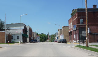
Neosho is a village in Dodge County, Wisconsin, United States. The population was 574 at the 2010 census.

<span class="mw-page-title-main">Brandon, Wisconsin</span> Village in Wisconsin, United States

Brandon is a village in Fond du Lac County, Wisconsin, United States. The population was 879 at the 2010 census.

<span class="mw-page-title-main">Monticello, Green County, Wisconsin</span> Village in Wisconsin, United States

Monticello is a village in Green County, Wisconsin, United States. The population was 1,217 as of the 2010 census.

<span class="mw-page-title-main">Edgar, Wisconsin</span> Village in Wisconsin, United States

Edgar is a village in Marathon County, Wisconsin, United States. It is part of the Wausau, Wisconsin Metropolitan Statistical Area. The population was 1,479 at the 2010 census. Edgar has maintained Tree City USA standing since 1995.

<span class="mw-page-title-main">Chaseburg, Wisconsin</span> Village in Wisconsin, United States

Chaseburg is a village in Vernon County, Wisconsin, United States. The population was 284 at the 2010 census.

<span class="mw-page-title-main">Clintonville, Wisconsin</span> City in Wisconsin, United States

Clintonville is a city in Waupaca County, Wisconsin, United States. The population was 4,591 at the 2020 census. The area that became Clintonville was first settled in March, 1855.

<span class="mw-page-title-main">Cazenovia, Wisconsin</span> Village in Wisconsin, United States

Cazenovia is a village in Richland and Sauk Counties in the U.S. state of Wisconsin. The population was 318 at the 2010 census. Of this, 314 were in Richland County, and only 4 were in Sauk County.

<span class="mw-page-title-main">Birnamwood, Wisconsin</span> Village in Wisconsin, United States

Birnamwood is a village in Marathon and Shawano counties in the U.S. state of Wisconsin. It is part of the Wausau, Wisconsin Metropolitan Statistical Area. The population was 818 at the 2010 census. Of this, 802 were in Shawano County, and 16 were in Marathon County. The village is located mostly within the town of Birnamwood in Shawano County; only a small portion extends into the town of Norrie in adjacent Marathon County. Until the 1990s, Birnamwood was home to the world's largest fiberglass badger. U.S. Route 45 runs through the village.

<span class="mw-page-title-main">Stockbridge (town), Wisconsin</span> Town in Wisconsin, United States

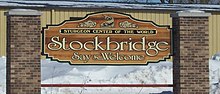
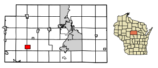
Stockbridge is a town in Calumet County, Wisconsin. The population was 1,456 at the time of the 2010 census. The village of Stockbridge, and the unincorporated communities of Kloten, Quinney, and Saint Catherines Bay are located within the town.

<span class="mw-page-title-main">Wauzeka, Wisconsin</span> Village in Wisconsin, United States

Wauzeka is a village in Crawford County, Wisconsin, United States. The population was 628 at the 2020 census. The village is located within the Town of Wauzeka near the confluence of the Kickapoo River and Wisconsin River.
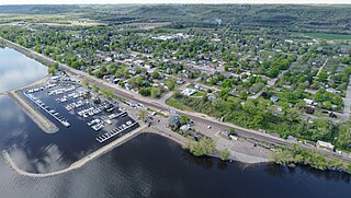
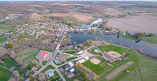
Oakfield is a town in Fond du Lac County, Wisconsin, United States. The population was 767 at the 2000 census. The Village of Oakfield is located within the town. The unincorporated community of Oak Center is also located in the town.

<span class="mw-page-title-main">Fennimore, Wisconsin</span> City in Wisconsin, United States

Fennimore is a city in Grant County, Wisconsin, United States. The population was 2,497 at the 2010 census. The city's area was separated from the Town of Fennimore, which remains as an adjacent rural area.

Melrose is a town in Jackson County, Wisconsin, United States. The population was 402 at the 2000 census. The Village of Melrose is located within the town.

<span class="mw-page-title-main">Milltown, Wisconsin</span> Village in Wisconsin, United States

Milltown is a village in Polk County, Wisconsin, United States. The population was 917 at the 2010 census. The village is located within the Town of Milltown.

<span class="mw-page-title-main">Rochester, Wisconsin</span> Village in Wisconsin

Rochester is a village in Racine County, Wisconsin, United States. The population was 3,785 at the 2020 census. The village is located within the former Town of Rochester. On November 4, 2008, the village of Rochester voted to consolidate with the Town of Rochester.

<span class="mw-page-title-main">Darien, Wisconsin</span> Village in Wisconsin, United States

Darien is a village in Walworth County, Wisconsin, United States. The population was 1,573 at the 2020 census. The village is located within the Town of Darien.

References

  1. "2019 U.S. Gazetteer Files". United States Census Bureau. Retrieved August 7, 2020.
  2. 1 2 "US Board on Geographic Names". United States Geological Survey. 2007-10-25. Retrieved 2008-01-31.
  3. 1 2 "U.S. Census website". United States Census Bureau . Retrieved 2012-11-18.
  4. 1 2 "Population and Housing Unit Estimates". United States Census Bureau. May 24, 2020. Retrieved May 27, 2020.
  5. 1 2 "U.S. Census website". United States Census Bureau . Retrieved 2008-01-31.
  6. "Stockbridge Area Business Association" . Retrieved 2007-12-10.
  7. "Stockbridge-Munsee History". Milwaukee Public Museum. Retrieved June 3, 2018.
  8. "US Gazetteer files: 2010, 2000, and 1990". United States Census Bureau. 2011-02-12. Retrieved 2011-04-23.
  9. "US Gazetteer files 2010". United States Census Bureau. Archived from the original on January 25, 2012. Retrieved 2012-11-18.
  10. "Census of Population and Housing". Census.gov. Retrieved June 4, 2015.