Clarks Mills, Wisconsin | |
|---|---|
 Clarks Mills, Wisconsin  Clarks Mills, Wisconsin | |
| Coordinates: 44°05′24″N87°51′51″W / 44.09000°N 87.86417°W | |
| Country | |
| State | |
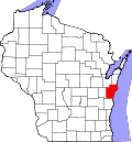
| County | Manitowoc |
| Elevation | 260 m (850 ft) |
| Time zone | UTC-6 (Central (CST)) |
| • Summer (DST) | UTC-5 (CDT) |
| Area code | 920 |
| GNIS feature ID | 1563123 [1] |
Clarks Mills is an unincorporated community located in the town of Cato, Manitowoc County, Wisconsin, United States. Clarks Mills is on the Manitowoc River northeast of Valders. It is named for early settler Ira Clark, who along with Thomas Cunningham built a mill and bridge there in the 1840s. [2]
Contents
The community is home to St. Mary's Catholic Church and St. Mary-St. Michael Catholic School.