Gibson, Wisconsin

Last updated
Gibson, Wisconsin
WIMap-doton-Gibson.png
Location of Gibson, Wisconsin
Coordinates: 44°16′49″N87°43′21″W / 44.28028°N 87.72250°W / 44.28028; -87.72250 Coordinates: 44°16′49″N87°43′21″W / 44.28028°N 87.72250°W / 44.28028; -87.72250
Country Flag of the United States.svg  United States
State Flag of Wisconsin.svg  Wisconsin
County Manitowoc
Area
  Total35.3 sq mi (91.5 km2)
  Land35.3 sq mi (91.3 km2)
  Water0.1 sq mi (0.2 km2)
Elevation
[1]
692 ft (211 m)
Population
 (2000)
  Total1,352
  Density38.3/sq mi (14.8/km2)
Time zone UTC-6 (Central (CST))
  Summer (DST) UTC-5 (CDT)
Area code 920
FIPS code 55-28975 [2]
GNIS feature ID1583272 [1]
Website www.townofgibsonwi.com

Gibson is a town in Manitowoc County, Wisconsin, United States. The population was 1,352 at the 2000 census.

Contents

Communities

Geography

According to the United States Census Bureau, the town has a total area of 35.3 square miles (91.5 km2), of which 35.3 square miles (91.3 km2) is land and 0.1 square miles (0.2 km2) (0.25%) is water.

Demographics

As of the census [2] of 2000, there were 1,352 people, 471 households, and 374 families residing in the town. The population density was 38.3 people per square mile (14.8/km2). There were 495 housing units at an average density of 14.0 per square mile (5.4/km2). The racial makeup of the town was 98.96% White, 0.07% African American, 0.07% Native American, 0.07% Asian, 0.07% Pacific Islander, and 0.74% from two or more races. Hispanic or Latino of any race were 0.52% of the population.

There were 471 households, out of which 39.3% had children under the age of 18 living with them, 70.5% were married couples living together, 3.6% had a female householder with no husband present, and 20.4% were non-families. 15.9% of all households were made up of individuals, and 5.5% had someone living alone who was 65 years of age or older. The average household size was 2.87 and the average family size was 3.23.

In the town, the population was spread out, with 28.6% under the age of 18, 7.2% from 18 to 24, 29.7% from 25 to 44, 26.1% from 45 to 64, and 8.5% who were 65 years of age or older. The median age was 37 years. For every 100 females, there were 116.7 males. For every 100 females age 18 and over, there were 117.1 males.

The median income for a household in the town was $48,438, and the median income for a family was $52,500. Males had a median income of $34,750 versus $26,339 for females. The per capita income for the town was $18,885. About 1.6% of families and 2.8% of the population were below the poverty line, including 3.3% of those under age 18 and 3.3% of those age 65 or over.

Notable people

Related Research Articles

<span class="mw-page-title-main">Williams Township, Michigan</span> Charter township in Michigan, United States

Williams Charter Township is a charter township of Bay County in the U.S. state of Michigan. The township's population was 5,058 as of the 2020 Census and is included in the Bay City Metropolitan Statistical Area.

<span class="mw-page-title-main">Glenmore, Wisconsin</span> Town in Wisconsin, United States

Glenmore is a town in Brown County in the U.S. state of Wisconsin. The population was 1,135 at the 2010 census.

<span class="mw-page-title-main">Carlton, Wisconsin</span> Town in Wisconsin, United States

Carlton is a town in Kewaunee County, Wisconsin, United States. The population was 1,014 at the 2010 census. Carlton is probably named for James Carlton, an early settler in the area.

<span class="mw-page-title-main">Franklin, Kewaunee County, Wisconsin</span> Town in Wisconsin, United States

Franklin is a town in Kewaunee County, Wisconsin, United States. The population was 993 at the 2010 census.

<span class="mw-page-title-main">Cato, Wisconsin</span> Town in Wisconsin, United States

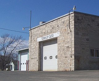
Cato is a town in Manitowoc County, Wisconsin, United States. The population was 1,616 at the 2000 census. A Manitowoc County park is located in the town which is called "Cato Falls" for a waterfall on the Manitowoc River.

<span class="mw-page-title-main">Cooperstown, Wisconsin</span> Town in Wisconsin, United States

Cooperstown is a town in Manitowoc County, Wisconsin, in the United States. As of the 2000 census, the town population was 1,403.

<span class="mw-page-title-main">Franklin, Manitowoc County, Wisconsin</span> Town in Wisconsin, United States

Franklin is a town in Manitowoc County, Wisconsin, United States. The population was 1,293 at the 2000 census.

<span class="mw-page-title-main">Liberty, Manitowoc County, Wisconsin</span> Town in Wisconsin, United States

Liberty is a town in Manitowoc County, Wisconsin, United States. The population was 1,287 at the 2000 census.

<span class="mw-page-title-main">Meeme, Wisconsin</span> Town in Wisconsin, United States

Meeme is a town in Manitowoc County, Wisconsin, United States. The population was 1,538 at the 2000 census. Its Menominee name is Omīnīw which means "pigeon". The Menominee sold this land to the United States in the 1831 Treaty of Washington.

<span class="mw-page-title-main">Newton, Manitowoc County, Wisconsin</span> Town in Wisconsin, United States

Newton is a town in Manitowoc County, Wisconsin, United States. The population was 2,241 at the 2000 census.

<span class="mw-page-title-main">Rockland, Manitowoc County, Wisconsin</span> Town in Wisconsin, United States

Rockland is a town in Manitowoc County, Wisconsin, United States. The population was 896 at the 2000 census. The unincorporated community of Collins is located in the town. The unincorporated community of Wells is also partially located in the town.

<span class="mw-page-title-main">Schleswig, Wisconsin</span> Town in Wisconsin, United States

Schleswig is a town in Manitowoc County, Wisconsin, United States. The population was 1,900 at the 2000 census.

<span class="mw-page-title-main">Two Creeks, Wisconsin</span> Town in Wisconsin, United States

Two Creeks is a town in Manitowoc County, Wisconsin, United States. The population was 551 at the 2000 census.

<span class="mw-page-title-main">Freedom, Outagamie County, Wisconsin</span> Town in Wisconsin, United States

Freedom is a town in Outagamie County, Wisconsin, United States. The population was 6,200 at the 2020 census. The unincorporated communities of Freedom and Murphy Corner are located in the town and the unincorporated community of Five Corners is located partially within the town.

<span class="mw-page-title-main">Herman, Sheboygan County, Wisconsin</span> Town in Wisconsin, United States

Herman is a town in Sheboygan County, Wisconsin, United States. The population was 2,044 at the 2000 census. It is included in the Sheboygan, Wisconsin Metropolitan Statistical Area.

<span class="mw-page-title-main">Mosel, Wisconsin</span> Town in Wisconsin, United States

Mosel or Moselle is a town in Sheboygan County, Wisconsin, United States. The population was 839 at the 2000 census. The town is included in the Sheboygan, Wisconsin Metropolitan Statistical Area.

<span class="mw-page-title-main">Vernon, Wisconsin</span> Village in Wisconsin, United States

Vernon is a village in Waukesha County, Wisconsin, United States. The population was 7,474 at the 2020 census.

Big Flats is an unincorporated community and census-designated place (CDP) within the town of Big Flats in Chemung County, New York, United States. The population of the CDP was 5,277 at the 2010 census, out of a total population in the town of 7,595.

The Town of Superior is a town in Douglas County, Wisconsin, United States. The population was 2,264 at the 2020 US census, up from 2,058 at the 2000 census. The Village of Superior is located within the town. The City of Superior is located immediately north and adjacent to both the Town of Superior and the Village of Superior.

<span class="mw-page-title-main">Mishicot (town), Wisconsin</span> Town in Wisconsin, United States

Mishicot is a town in Manitowoc County, Wisconsin, United States. The population was 1,409 at the 2000 census. The Village of Mishicot is located within the town. The unincorporated communities of Fisherville, Kingsbridge, and Tisch Mills are also located partially in the town.

References

  1. 1 2 "US Board on Geographic Names". United States Geological Survey. 2007-10-25. Retrieved 2008-01-31.
  2. 1 2 "U.S. Census website". United States Census Bureau . Retrieved 2008-01-31.
  3. "Steven Avery case: What did the court documents say?" WSAW-TV, January 5, 2016.