Branch, Wisconsin | |
|---|---|
 Looking west at Branch | |
 Branch, Wisconsin  Branch, Wisconsin | |
| Coordinates: 44°08′45″N87°45′40″W / 44.14583°N 87.76111°W | |
| Country | |
| State | |
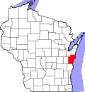
| County | Manitowoc |
| Elevation | 229 m (751 ft) |
| Time zone | UTC-6 (Central (CST)) |
| • Summer (DST) | UTC-5 (CDT) |
| Area code | 920 |
| GNIS feature ID | 1562140 [1] |
Branch is an unincorporated community located in the Town of Manitowoc Rapids, in Manitowoc County, Wisconsin, United States. Branch is located on U.S. Route 10, east of Whitelaw.
Branch was named for the nearby Branch River, which flows into the Manitowoc River. [2]