
Sheboygan County is a county in the U.S. state of Wisconsin. It is named after the Sheboygan River. As of the 2010 census, the population was 115,507. Its county seat is Sheboygan. The county was created in 1836 and organized in 1846. At the time, it was located in the Wisconsin Territory.
Kewaunee County is a county located in the U.S. state of Wisconsin. As of the 2010 census, the population was 20,574. Its county seat is Kewaunee. The county was created in 1852 and organized in 1859.

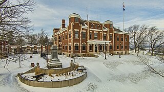
Calumet County is a county located in the U.S. state of Wisconsin. As of the 2010 census, the population was 48,971. The county seat is Chilton. The county was created in 1836 and organized in 1850.

Quincy is a town in Adams County in the U.S. state of Wisconsin. The population was 1,163 at the 2010 census. The ghost town of Quincy was located in the town.
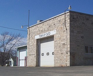
Cato is a town in Manitowoc County, Wisconsin, United States. The population was 1,616 at the 2000 census. The unincorporated communities of Cato, Cato Falls, Clarks Mills, Grimms, Madsen, and North Grimms are located within the town. A Manitowoc County park is located in the town which is called "Cato Falls" for a waterfall on the Manitowoc River.

Maribel is a village in Manitowoc County, Wisconsin, United States. The population was 351 at the 2010 census.

Newton is a town in Manitowoc County, Wisconsin, United States. The population was 2,241 at the 2000 census. The unincorporated communities of Clover, Duveneck, Newton, Newtonburg, and Northeim are located in the town. The unincorporated community of Rube is also located partially in the town.

Valders is a village in Manitowoc County, Wisconsin, United States. The population was 962 at the 2010 census.

Manitowoc is a city in and the county seat of Manitowoc County, Wisconsin, United States. The city is located on Lake Michigan at the mouth of the Manitowoc River. According to the 2010 census, Manitowoc had a population of 33,736, with over 50,000 residents in the surrounding communities. The city's sister city is Kamogawa, Japan.

Sturgeon Bay is a city in and the county seat of Door County, Wisconsin, United States. The population was 9,144 at the 2010 census. It is located at the natural end of Sturgeon Bay, although the Sturgeon Bay Ship Canal was built across the remainder of the Door Peninsula.

The Sheboygan River is a river flowing to Lake Michigan in eastern Wisconsin in the United States. It is about 81 mi (130 km) long and enters the lake at the city of Sheboygan. The name of the river is Native American in origin, meaning 'noise underground' or 'river disappearing underground'.
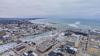
The Manitowoc River is a 35.8-mile-long (57.6 km) river in eastern Wisconsin in the United States. It flows into Lake Michigan at the city of Manitowoc.

The Branch River is a 36.9-mile-long (59.4 km) river in eastern Wisconsin in the United States. It is a tributary of the Manitowoc River, which flows to Lake Michigan.

Collins is an unincorporated census-designated place in the town of Rockland, Manitowoc County, Wisconsin, United States, in the east central part of the state. Its zip code is 54207, although its post office is being studied for closure. As of the 2010 census, its population is 164. The Collins Marsh Wildlife Area is located east of the community. Wisconsin Highway 32 ran through the community; the route later became Wisconsin Highway 67 before it became County Highway W. County Highway JJ and the Wisconsin Central Ltd. railroad runs east–west through the community. Collins has an area of 0.496 square miles (1.28 km2), all of it land. The community was named for Sumner J. Collins, who was the general superintendent of the Wisconsin Central Railroad in the 1890s.
Millhome is an unincorporated community in the town of Schleswig, Manitowoc County, Wisconsin, United States. The nearest city to Millhome is Kiel. The community is located just west of the intersection of Wisconsin Highway 32 and Wisconsin Highway 57 and is along the border between Manitowoc and Sheboygan Counties. The Sheboygan River passes through the community.
Tisch Mills is an unincorporated community in Kewaunee and Manitowoc Counties, Wisconsin, United States. Tisch Mills is located in the towns of Mishicot in Manitowoc County and Carlton in Kewaunee County, 5 miles from the village of Mishicot. It is at an elevation of 636 feet.
Waubeka is an unincorporated census-designated place in the town of Fredonia, Ozaukee County, Wisconsin, United States, in the Milwaukee-Waukesha metro area. As of the 2010 census, its population is 657. It was named for an Indian chief, whose name means "metallic substance".
Madsen is an unincorporated community located in the town of Cato, Manitowoc County, Wisconsin, United States. Madsen is located on County Highway S and the Canadian National Railway near U.S. Route 151, 8.2 miles (13.2 km) west of Manitowoc.


