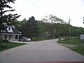
Steinthal, Wisconsin | |
|---|---|
 Welcome sign | |
 Steinthal, Wisconsin  Steinthal, Wisconsin | |
| Coordinates: 43°58′57″N88°00′08″W / 43.98250°N 88.00222°W | |
| Country | |
| State | |
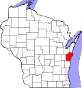
| County | Manitowoc |
| Elevation | 264 m (866 ft) |
| Time zone | UTC-6 (Central (CST)) |
| • Summer (DST) | UTC-5 (CDT) |
| Area code | 920 |
| GNIS feature ID | 1577838 [1] |
Steinthal is an unincorporated community in the Town of Eaton, Manitowoc County, Wisconsin, United States. [1] [2] The community had a post office and general store. [2]