
Log Lane Village is a statutory town in Morgan County, Colorado, United States. The population was 913 at the 2020 census.

Gilliam is a village in Caddo Parish, Louisiana, United States. The population was 164 at the 2010 census. It is part of the Shreveport–Bossier City Metropolitan Statistical Area.
Stetson is a town in Penobscot County, Maine, United States. The population was 1,186 at the 2020 census. It was named after its first proprietor, Amasa Stetson. His brother Simeon Stetson originally settled here as well, but moved to nearby Hampden in 1803. Simeon's sons Charles, George, and Isaiah founded a powerful mercantile and political family in Bangor.

Cedar Hill Lakes is a village in Jefferson County, Missouri, United States. The population was 203 at the 2020 census.
Sycamore Hills is a village in St. Louis County, Missouri, United States. The population is 560 at the 2020 census.

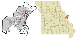
Uplands Park is a village in St. Louis County, Missouri, United States. The population was 445 at the 2010 census. The village is one of many small majority black communities located in the Natural Bridge corridor of mid-St. Louis County, characterized by small homes on small lots.
Cedarville is a village in Greene County, Ohio, United States. The village is within the Dayton Metropolitan Statistical Area. The population was 4,257 at the 2020 census.

Addyston is a village in Miami Township, Hamilton County, Ohio, United States. Located along the Ohio River, it is a western suburb of the neighboring city of Cincinnati. The population was 927 at the 2020 census.

Fairfax is a village in Hamilton County, Ohio, United States. It is a suburb of Cincinnati. The population was 1,768 at the 2020 census.

Alba is a borough in Bradford County, Pennsylvania, United States. It is part of Northeastern Pennsylvania. The population was 135 at the 2020 census.

Stagecoach is a town in Montgomery County, Texas, United States. The population was 580 at the 2020 census.

Plains is a town in and the county seat of Yoakum County of western Texas, United States. The city's population was 1,355 at the 2020 census. Yoakum County is in the Texas High Plains Wine country.

Bellevue is a village in Brown County, Wisconsin. It was a town until incorporating as a village on February 14, 2003. The population was 15,935 at the time of the 2020 census. Bellevue is part of the Green Bay metropolitan area. Bellevue sits around 4.34 miles (6.99 km) east from central Green Bay.

Valders is a village in Manitowoc County, Wisconsin, United States. The population was 962 at the 2010 census.

Bay City is a village on the Mississippi River in Pierce County, Wisconsin, United States. The population was 500 at the 2010 census.

Big Falls is a village in Waupaca County, Wisconsin, United States. The population was 61 at the 2010 census.

Wilson is a village in Belmont and Monroe counties in the U.S. state of Ohio. The population was 129 at the 2020 census. It is part of the Wheeling metropolitan area.

Verona is a village in Montgomery and Preble counties in the U.S. state of Ohio. The population was 403 at the 2020 census. It is part of the Dayton Metropolitan Statistical Area.

Unity is a village in Clark and Marathon counties in the U.S. state of Wisconsin. It is part of the Wausau, Wisconsin Metropolitan Statistical Area. The population was 343 at the 2010 census. Of this, 204 were in Marathon County, and 139 were in Clark County. The village is located in northeastern town of Unity in Clark County and northwestern town of Brighton in Marathon County.

Oconto Falls is a city in Oconto County, Wisconsin, United States. The population was 2,957 at the 2020 census. It is part of the Green Bay Metropolitan Statistical Area.


