Related Research Articles

Mañagaha is a small islet which lies off the west coast of Saipan within its lagoon in the Northern Mariana Islands. Although it has no permanent residents, Mañagaha is popular among Saipan's tourists as a day-trip destination due to its wide sandy beaches and a number of marine activities including snorkeling, parasailing and jet skiing.

This is a list of the buildings, sites, districts, and objects listed on the National Register of Historic Places in the Northern Mariana Islands. There currently 37 listed sites spread across the four municipalities of the Northern Mariana Islands. There are no sites listed on any of the islands that make up the Northern Islands Municipality.

Coso Rock Art District is a rock art site containing over 100,000 Petroglyphs by Paleo-Indians and/or Native Americans. The district is located near the towns of China Lake and Ridgecrest, California. Big and Little Petroglyph Canyons were declared a National Historic Landmark in 1964. In 2001, they were incorporated into this larger National Historic Landmark District. There are several other distinct canyons in the Coso Rock Art District besides the Big and Little Petroglyph Canyons. Also known as Little Petroglyph Canyon and Sand Tanks, Renegade Canyon is but one of several major canyons in the Coso Range, each hosting thousands of petroglyphs. The majority of the Coso Range images fall into one of six categories: bighorn sheep, entopic images, anthropomorphic or human-like figures, other animals, weapons & tools, and "medicine bag" images. Scholars have proposed a few potential interpretations of this rock art. The most prevalent of these interpretations is that they could have been used for rituals associated with hunting.

The following is an alphabetical list of articles related to the Commonwealth of the Northern Mariana Islands.
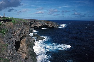
Banzai Cliff is a historical site at the northern tip of Saipan island in the Northern Mariana Islands, overlooking the Pacific Ocean. Towards the end of the Battle of Saipan in 1944, hundreds of Japanese civilians and soldiers jumped off the cliff to their deaths in the ocean and rocks below, to avoid being captured by the Americans. Not far away, a high cliff named Suicide Cliff overlooks the coastal plain, and was another site of numerous suicides. At Banzai Cliff, some who jumped did not die and were captured by American ships.

The Chugai' Pictograph Site is a prehistoric rock art site on the island of Rota in the Northern Mariana Islands. The rock art is located in a limestone cave on the southeastern side of the island, in the I'Chenchon Bird Sanctuary. It consists of a large panel, 185 feet (56 m) in length, of about 90 painted drawings, believed to be of late pre-contact origin. The site is accessed via a trail cut by the Japanese during the South Seas Mandate period.
The Dugi Archeological Site is a prehistoric latte stone site on the north side of Rota Island in the Northern Mariana Islands. The site is a rare inland site that survived the intensive sugar cane development introduced by the Japanese during the South Seas Mandate period of the 1920s and 1930s. It consists of sixteen deteriorated latte stone structures on three high terraces. Some of the latte stones have fallen over and others are missing features normally found at these sites.
Tachognya, also known as the Blue Site, is a prehistoric village site on the island of Saipan in the Northern Mariana Islands. It is located near the "Blue Beach" landing site of Allied forces in the Battle of Saipan, from which its name is derived. The site consists of ten latte stone house foundations, the largest of which has twelve latte columns and measures 14 by 58 feet.

The Laulau Kattan Latte Site is a prehistoric archaeological site on the island of Saipan in the Northern Mariana Islands. Located near the shore of Laulau Bay, it is a small village site containing the remains of four latte stone house foundations, and an extensive scattering of pottery artifacts. When first reported by the pioneering archaeologist Alexander Spoehr in the 1940s, the latte stones were described as mostly fallen over and extremely weathered.
The Unai Lagua Japanese Defense Pillbox is one of the more unusual surviving World War II-era Japanese fortifications on the island of Saipan in the Northern Mariana Islands. It is located at the southern end of Unai Lagua, which stretches along the northern shore of the island. The pillbox is fashioned out of poured concrete and coral boulders, and uses natural rock formations as part of its walls. This construction was necessitated by a severe shortage of building materials on the island as the Japanese prepared the island's defenses against the advancing Allied forces in 1943–44. The use of natural materials and terrain had the added benefit of rendering the position nearly invisible to aerial or offshore observation.
The Unai Obyan Latte Site is a prehistoric archaeological site on the island of Saipan in the Northern Mariana Islands. Located near Obyan Beach on the south coast of the island, it is the site of what was once a fairly extensive village, which was significantly disturbed by Japanese defensive preparations during World War II. The site includes the fragmentary remains of a single latte stone house site and a wide scattering of surface-level remains. Excavation of the latte house site in the 1940s by the pioneering archeologist Alexander Spoehr yielded evidence of a length period of occupation. The village at Obyan was documented in early Spanish accounts of the island, and was probably abandoned when the Spanish forcibly relocated the entire island population to Guam in 1698.
The Talagi Pictograph Cave is a rock art site on the island of Guam. It is located on property owned by the government of Guam within the bounds of Andersen Air Force Base on the northern part of the island near Tarague Beach. The cave contains thirteen pictographs representing human figures, and a places where limestone mortar was used that is of prehistoric origin. Based on the characteristics of the figures, it is believed that they were probably the work of a single individual. It is one of a small number known rock art sites on the island.
Chalan Galaide is a late prehistoric latte stone archaeological site on the island of Saipan in the Northern Mariana Islands. It is unusual as one of the few inland latte sites in the Northern Marianas. It is a single-component site dating to the late prehistoric, or Latte Period, in the island's history. Based in part on the local name for the area and the presence of suitable tree species, it has been suggested the site was important in the production of canoes..
The Unai Achugao Archaeological Site is a major archaeological site on the island of Saipan in the Northern Mariana Islands. This site is one of the first sites at which reliable radiocarbon dates were acquired for the early habitation of the island, which were dated to about 3500 BCE. Excavations at the site also yielded more than 3,000 pottery fragments, which were used in the early classification of pottery types in the region. The site also included a nearly-intact habitation surface which was protected by a fossilized coral reef.

The Nan'yō Kōhatsu Kabushiki Kaisha Sugar Mill is a former industrial facility in the village of Songsong on the island of Rota in the Northern Mariana Islands. Its ruins are a significant reminder of the South Seas Mandate period, when Imperial Japan engaged in large-scale sugar cane farming in the Northern Marianas, and are the only brick structure in the Northern Marianas. The sugar mill on Rota was one of the major installations of the Nan'yō Kōhatsu Kabushiki Kaisha, the Japanese company responsible for economic development of the mandate area. Its executive director turned board chairman, Haruji Matsue, considered the Northern Mariana Islands the best place to establish the sugar industry, and more especially since previous Japanese commercial enterprises tried their hand at growing and processing sugar cane, but failed. The Nan'yō Kōhatsu Kabushiki Kaisha, was the most dominant economic force and being the largest Japanese Corporation, came to the Northern Marianas in 1921. Not unlike its predecessors, the NKK experienced a very tough few years, which almost forced the company to cease operations. Things started to take a turn for the better in 1926. By the early 1930s, Matsue proceeded to expand the company's landholdings and operations to Tinian and Rota, respectively. Rota had one mill and 38% of the farmlands had sugar cane growing. The remnants of this sugar mill, all that survived the Allied capture of Rota during World War II, are located on the north side of the peninsula that projects southwest from Songsong, and consist of fragments of brick and concrete structures. The most impressive single element is a brick and concrete tunnel 42.5 metres (139 ft) long, from which openings lead to the locations of other parts of the once-extensive complex.

Mochong is a major prehistoric archaeological site on the island of Rota in the Northern Mariana Islands. It is considered the best preserved and second largest latte village in the Marianas. It is an extensive village site on the northern side of the island comprising 50 individual latte sets, scattered mortars (lusongs), scattered subsurface artifacts such as tools, fishing implements and abundance pieces of pottery; the Marianas Red Ware Pottery and the Marianas Plain Ware Pottery. This site also includes an extremely rare latte house structure consisting of 14 columns. It also has a latte stone wall, consisting of six columns and five slabs, that is more than 50 feet (15 m) long. The site has been radiocarbon dated to c. 1000 BCE. The site was first sketched in the early 19th century by the French explorer Louis de Freycinet, and was in remarkably intact condition in the 1980s.
The Mahlac Pictograph Cave is a rock art site on the island of Guam. It is located high in the southern mountains of the island, and contains more than 40 images, rendered in paints that are white, red, brown, and black. The art was carefully analyzed in 2011, and a radiocarbon date of c. 600 CE was obtained from a paint sample. The meaning of the art is a subject of debate.

Gadao's Cave, also known as Liyang Gadao, is a rock art site on the United States island of Guam. Located near the village of Inarajan, the cave is the site of a panel of approximately 50 Chamorro pictographs, painted with a mixture of coral lime and tree sap. The most unusual images are of two human stick figures that appear to be carrying things. It is not known who painted them or when, and what their significance is. The legendary chief of Inarajan Gadao is believed to be the creator of the cave's images.
The eastern part of the United States state of Maine is known to have historically significant examples of prehistoric and historic rock art. The easternmost shore, particularly the shores and islands of Machias Bay, contain one of the greatest concentrations of rock art on the east coast of North America, with creation dates estimated to range from c. 1000 BCE to beyond the European contact period. Many of these sites are listed on the United States National Register of Historic Places.
References
- 1 2 "National Register Information System". National Register of Historic Places . National Park Service. July 9, 2010.
- ↑ Cabrera, Genevieve; Tudela, Herman (November 2006). "Conversations with I Man-Aniti: Interpretation of Discoveries of the Rock Art in the Northern Mariana Islands" (PDF). Micronesian Journal of the Humanities and Social Sciences. 5 (1–2).

| | This article about a property in the Northern Mariana Islands on the National Register of Historic Places is a stub. You can help Wikipedia by expanding it. |