List of volcanic craters in Arizona

Last updated

S P Crater SP Crater.jpg
S P Crater

The United States National Geodetic Survey lists 28 volcanic craters in the state of Arizona.

Contents

Coconino County

Double Crater Double Crater AZ.jpg
Double Crater
Sunset Crater SUCR2262.jpg
Sunset Crater

Cochise County

Greenlee County

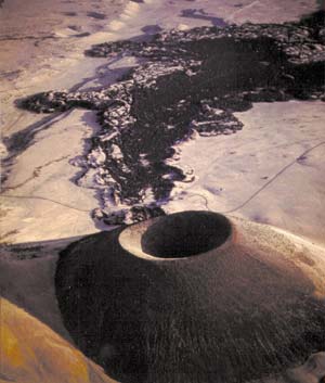
Located just northeast of the town of Clifton, Arizona, this dormant cinder cone volcano and crater is easily visible from the town and In the satellite view of Google Maps. The area is still geologically active, with several hot springs in the area.

See also

Related Research Articles

Meteor Crater Meteorite impact crater in northern Arizona

Meteor Crater, or Barringer Crater, is a meteorite impact crater about 37 mi (60 km) east of Flagstaff and 18 mi (29 km) west of Winslow in the desert of northern Arizona, United States. The site had several earlier names, and fragments of the meteorite are officially called the Canyon Diablo Meteorite, after the adjacent Cañon Diablo. Because the United States Board on Geographic Names recognizes names of natural features derived from the nearest post office, the feature acquired the name of "Meteor Crater" from the nearby post office named Meteor.

Eugene Merle Shoemaker American geologist and astronomer (1928–1997)

Eugene Merle Shoemaker was an American geologist. He co-discovered Comet Shoemaker–Levy 9 with his wife Carolyn S. Shoemaker and David H. Levy. This comet hit Jupiter in July 1994: the impact was televised around the world. Shoemaker also studied terrestrial craters, such as Barringer Meteor Crater in Arizona, and along with Edward Chao provided the first conclusive evidence of its origin as an impact crater. He was also the first director of the United States Geological Survey's Astrogeology Research Program.

Volcanic cone Landform of ejecta from a volcanic vent piled up in a conical shape

Volcanic cones are among the simplest volcanic landforms. They are built by ejecta from a volcanic vent, piling up around the vent in the shape of a cone with a central crater. Volcanic cones are of different types, depending upon the nature and size of the fragments ejected during the eruption. Types of volcanic cones include stratocones, spatter cones, tuff cones, and cinder cones.

Cinder Cone and the Fantastic Lava Beds Cinder cone in the United States of America

Cinder Cone is a cinder cone volcano in Lassen Volcanic National Park within the United States. It is located about 10 mi (16 km) northeast of Lassen Peak and provides an excellent view of Brokeoff Mountain, Lassen Peak, and Chaos Crags.

Sunset Crater Cinder cone in Coconino County, Arizona, US

Sunset Crater is a cinder cone located north of Flagstaff in the U.S. state of Arizona. The crater is within the Sunset Crater Volcano National Monument.

San Francisco volcanic field Part of the San Francisco Peaks in northern Arizona

The San Francisco volcanic field is an area of volcanoes in northern Arizona, north of Flagstaff, US. The field covers 1,800 square miles (4,700 km²) of the southern boundary of the Colorado Plateau. The field contains 600 volcanoes ranging in age from nearly 6 million years old to less than 1,000 years, of which Sunset Crater is the youngest. The highest peak in the field is Humphreys Peak, at Flagstaff's northern perimeter: the peak is Arizona's highest at 12,633 feet and is a part of the San Francisco Peaks, an extinct stratovolcano complex.

Pisgah Crater

Pisgah Crater, or Pisgah Volcano, is a young volcanic cinder cone rising above a lava plain in the Mojave Desert, between Barstow and Needles, California in San Bernardino County, California. The volcanic peak is around 2.5 miles (4.0 km) south of historic U.S. Route 66-National Old Trails Highway and of Interstate 40, and west of the town of Ludlow. The volcano had a historic elevation of 2,638 feet (804 m), but has been reduced to 2,545 feet (776 m) due to mining.

Canyon Diablo (meteorite) Iron meteorite from Meteor Crater used as sulfur isotopic reference material

The Canyon Diablo meteorite refers to the many fragments of the asteroid that created Meteor Crater, Arizona, United States. Meteorites have been found around the crater rim, and are named for nearby Canyon Diablo, which lies about three to four miles west of the crater.

Coconino National Forest United States protected area in Arizona

The Coconino National Forest is a 1.856-million acre United States National Forest located in northern Arizona in the vicinity of Flagstaff. Originally established in 1898 as the "San Francisco Mountains National Forest Reserve", the area was designated a U.S. National Forest in 1908 when the San Francisco Mountains National Forest Reserve was merged with lands from other surrounding forest reserves to create the Coconino National Forest. Today, the Coconino National Forest contains diverse landscapes, including deserts, ponderosa pine forests, flatlands, mesas, alpine tundra, and ancient volcanic peaks. The forest surrounds the towns of Sedona and Flagstaff and borders four other national forests; the Kaibab National Forest to the west and northwest, the Prescott National Forest to the southwest, the Tonto National Forest to the south, and the Apache-Sitgreaves National Forest to the southeast. The forest contains all or parts of ten designated wilderness areas, including the Kachina Peaks Wilderness, which includes the summit of the San Francisco Peaks. The headquarters are in Flagstaff. There are local ranger district offices in Flagstaff, Happy Jack, and Sedona.

Astrogeology Research Program Division of the US Geological Survey which studies planetary geology and cartography

The Astrogeology Science Center is the entity within the United States Geological Survey concerned with the study of planetary geology and planetary cartography. It is housed in the Shoemaker Building in Flagstaff, Arizona. The Center was established in 1963 by Eugene Merle Shoemaker to provide lunar geologic mapping and to assist in training astronauts destined for the Moon as part of the Apollo program.

S P Crater Cinder cone volcano in Arizona

S P Crater is a cinder cone volcano in the San Francisco volcanic field, 25 miles (40 km) north of Flagstaff, Arizona. It is surrounded by several other cinder cones which are older and more eroded. It is a striking feature on the local landscape, with a well-defined lava flow that extends for 4.3 miles (7 km) to the north.

Cinder cone Steep conical hill of loose pyroclastic fragments around a volcanic vent

A cinder cone is a steep conical hill of loose pyroclastic fragments, such as volcanic clinkers, volcanic ash, or cinder that has been built around a volcanic vent. The pyroclastic fragments are formed by explosive eruptions or lava fountains from a single, typically cylindrical, vent. As the gas-charged lava is blown violently into the air, it breaks into small fragments that solidify and fall as either cinders, clinkers, or scoria around the vent to form a cone that often is symmetrical; with slopes between 30 and 40°; and a nearly circular ground plan. Most cinder cones have a bowl-shaped crater at the summit.

San Felipe volcanic field Volcanic field in northern New Mexico, US

San Felipe volcanic field is a monogenetic volcanic field located just north of the confluence of the Jemez River and the Rio Grande in New Mexico, US.

OLeary Peak Extinct Pleistocene lava dome volcano in Arizona

O'Leary Peak is an extinct Pleistocene lava dome volcano within the San Francisco volcanic field, north of Flagstaff, Arizona, and to the northwest of Sunset Crater National Monument. A fire lookout tower was built on a subsidiary eastern peak. It has an elevation of 8,919 feet (2,719 m).

Double Crater Extinct Pleistocene volcano in Coconino County, Arizona

Double Crater is an extinct Pleistocene volcano within the San Francisco volcanic field, north of Flagstaff, Arizona. It is to the southeast of Sunset Crater.

Red Mountain (Coconino County, Arizona) Volcanic cinder cone in Coconino County, Arizona, US

Red Mountain is a volcanic cinder cone located in the Coconino National Forest of northern Arizona, United States, 25 miles northwest of Flagstaff. It rises 1,000 feet (300 m) above the surroundings terrain and is shaped like the letter "U", with its opening towards the west. Geological Survey (USGS) and Northern Arizona University scientists suggest that Red Mountain was formed in eruptions nearly 740,000 years ago.

Strawberry Crater Cinder cone volcano in Coconino County, Arizona, US

Strawberry Crater is a cinder cone volcano, more than 1,000 feet (300 m) high, in the San Francisco volcanic field, 20 miles (32 km) north of Flagstaff, Arizona. It is along Forest Road 545 between the Wupatki National Monument and Sunset Crater National Monument in the Strawberry Crater Wilderness. The crater lies in a volcanic field at a base elevation of about 5,500 feet (1,700 m), and prominence heights of about 6,526 feet (1,989 m). The northwestern end of the crater is covered with lava flows, while the southern end is filled with low cinder cones. Several of the surrounding cones include the better known, taller and younger Sunset Crater in the adjacent Sunset Crater National Monument.

Black Bottom Crater is a volcanic crater located in Arizona, east-northeast of Sunset Crater, and west-southwest of Roden Crater. To the northwest is Strawberry Crater. Black Bottom Crater is a cinder cone in the San Francisco volcanic field.

Lenox Crater is a cinder cone located in the San Francisco Volcanic Field in Coconino County, near Flagstaff, Arizona, an area known for volcanic activity. The volcano erupted approximately 1,000 years ago, filling a small depression with ash and volcanic cinders. The lava flow from the eruption flowed near the base of Sunset Crater.

References

  1. Ulrich, G.E., Billingsley, G.H., Hereford, Richard, Wolfe, E.W., Nealey, L.D. and Sutton, R.L., 1984, Map showing geology, structure, and uranium deposits of the Flagstaff 1 degrees x 2 degrees quadrangle, Arizona: U.S. Geological Survey, Miscellaneous Investigations Series Map I-1446, scale 1:250000.
  2. USGS GNIS Feature Detail Report: Robinson Crater
  3. Finkel, Jori (2007-11-25). "Shh! It's a Secret Kind of Outside Art". The New York Times . Retrieved 2009-08-22.
  4. Susan S. Priest; Wendell A. Duffield; Karen Malis-Clark; James W. Hendley II; Peter H. Stauffer (2001-12-21). "The San Francisco Volcanic Field, Arizona: USGS Fact Sheet 017-01". United States Geological Survey . Retrieved 2008-09-02.{{cite journal}}: Cite journal requires |journal= (help)
  5. "Sunset Crater Volcano National Monument". National Park Service. 2007-09-14. Retrieved 2008-08-12.
  6. Melosh HJ, Collins GS (2005). "Planetary science: Meteor Crater formed by low-velocity impact". Nature . 434 (7030): 157. Bibcode:2005Natur.434..157M. doi: 10.1038/434157a . PMID   15758988.
  7. Roddy, D. J.; E. M. Shoemaker (1995). "Meteor Crater (Barringer Meteorite Crater), Arizona: summary of impact conditions". Meteoritics. 30 (5): 567. Bibcode:1995Metic..30Q.567R.