List of islands of Arizona

Last updated

Islands of the state of Arizona
Map of USA AZ.svg
Location of Arizona within the United States
Geography
Location Arizona
Total islands34 named
Administration
StateFlag of Arizona.svg  Arizona

The following is a list of islands of Arizona. With 113,634.57 square miles (294,312.2 km2) of land, the state of Arizona is the sixth-largest in the United States. It is the third-largest state to not have an ocean coastline—after Montana and New Mexico. Despite being landlocked, Arizona does contain islands, even though the state has the third-lowest amount of water, only 363.73 square miles (942.1 km2) after West Virginia and New Mexico. Arizona's 0.32% of water is the second-lowest percentage after New Mexico's 0.2% of water. [1] The majority of Arizona's islands are in the Colorado River (mainly Lake Mead). Lake Roosevelt also contains a number of islands. The premise of country music artist George Strait's 1986 song "Ocean Front Property" revolves around the fact that Arizona is not located on an ocean.

IslandBody of waterCountyCoordinates
Antelope Island Lake Powell Coconino 36°59′00″N111°26′00″W / 36.98333°N 111.43333°W / 36.98333; -111.43333 (Antelope Island)
Beaver Island Colorado River Mohave 34°25′18″N114°17′28″W / 34.42167°N 114.29111°W / 34.42167; -114.29111 (Beaver Island)
Beehive Island Colorado River Mohave 36°04′20″N114°43′34″W / 36.07222°N 114.72611°W / 36.07222; -114.72611 (Beehive Island)
Bulls Head Rock Lake Mohave Mohave 35°12′17″N114°34′22″W / 35.20472°N 114.57278°W / 35.20472; -114.57278 (Bulls Head Rock)
Channel Island Colorado River Mohave 36°01′42″N114°08′30″W / 36.02833°N 114.14167°W / 36.02833; -114.14167 (Channel Island)
Decision Island Lake Mead Mohave 36°02′22″N114°17′04″W / 36.03944°N 114.28444°W / 36.03944; -114.28444 (Decision Island)
Deer Island Colorado River La Paz 34°07′00″N114°22′30″W / 34.11667°N 114.37500°W / 34.11667; -114.37500 (Deer Island)
Driftwood Island Colorado River Mohave 36°11′34″N114°01′31″W / 36.19278°N 114.02528°W / 36.19278; -114.02528 (Driftwood Island)
Haulapai Island Colorado River Mohave 36°01′54″N114°08′09″W / 36.03167°N 114.13583°W / 36.03167; -114.13583 (Haulapai Island)
Haystack Island Lake Roosevelt Gila 33°41′47″N111°07′45″W / 33.69639°N 111.12917°W / 33.69639; -111.12917 (Haystack Island)
Heron Point Lake Mead Mohave 36°02′51″N114°18′41″W / 36.04750°N 114.31139°W / 36.04750; -114.31139 (Heron Point)
Hi Isle Lake Havasu Mohave 34°18′57″N114°08′35″W / 34.31583°N 114.14306°W / 34.31583; -114.14306 (Hi Isle)
Hog Island Bartlett Lake Maricopa 33°50′25″N111°37′01″W / 33.84028°N 111.61694°W / 33.84028; -111.61694 (Hog Island)
Houseboat Island Lake Mead Mohave 36°04′03″N114°20′09″W / 36.06750°N 114.33583°W / 36.06750; -114.33583 (Houseboat Island)
Mohave Rock Colorado River Mohave 34°36′46″N114°25′28″W / 34.61278°N 114.42444°W / 34.61278; -114.42444 (Mohave Rock)
Napoleans Tomb Lake Mead Mohave 36°07′09″N114°21′27″W / 36.11917°N 114.35750°W / 36.11917; -114.35750 (Napoleans Tomb)
Panic Rock Bartlett Lake Maricopa 33°49′29″N111°37′18″W / 33.82472°N 111.62167°W / 33.82472; -111.62167 (Panic Rock)
Pittsburg Point Colorado River Mohave 34°27′37″N114°21′36″W / 34.46028°N 114.36000°W / 34.46028; -114.36000 (Pittsburg Point)
Plane Crash Island Lake Mead Mohave 36°03′26″N114°19′57″W / 36.05722°N 114.33250°W / 36.05722; -114.33250 (Plane Crash Island)
Pool Islands (5 islands) Lake Mead Mohave 36°05′54″N114°27′58″W / 36.09833°N 114.46611°W / 36.09833; -114.46611 (Pool Islands)
Punk Rock Verde River Yavapai 34°25′33″N111°46′43″W / 34.42583°N 111.77861°W / 34.42583; -111.77861 (Punk Rock)
Rabbit Island Lake Roosevelt Gila 33°41′49″N111°08′49″W / 33.69694°N 111.14694°W / 33.69694; -111.14694 (Rabbit Island)
River Island Colorado River Mohave 34°39′28″N114°26′58″W / 34.65778°N 114.44944°W / 34.65778; -114.44944 (River Island)
Rock Island Lake Roosevelt Gila 33°41′16″N111°08′25″W / 33.68778°N 111.14028°W / 33.68778; -111.14028 (Rock Island)
Saddle Island Lake Roosevelt Gila 33°39′32″N111°04′16″W / 33.65889°N 111.07111°W / 33.65889; -111.07111 (Saddle Island)
Shelter Island Lake Roosevelt Gila 33°40′05″N111°04′48″W / 33.66806°N 111.08000°W / 33.66806; -111.08000 (Shelter Island)
Ship Rock Saguaro Lake Maricopa 33°33′48″N111°29′47″W / 33.56333°N 111.49639°W / 33.56333; -111.49639 (Ship Rock)
Steamboat Rock Lake Roosevelt Gila 33°40′50″N111°05′03″W / 33.68056°N 111.08417°W / 33.68056; -111.08417 (Steamboat Rock)
Two Rocks (2 islands) Colorado River Mohave 35°43′30″N114°42′00″W / 35.72500°N 114.70000°W / 35.72500; -114.70000 (Two Rocks)

Related Research Articles

<span class="mw-page-title-main">Lake Michigan</span> One of the Great Lakes of North America

Lake Michigan is one of the five Great Lakes of North America. It is the second-largest of the Great Lakes by volume and the third-largest by surface area, after Lake Superior and Lake Huron. To the east, its basin is conjoined with that of Lake Huron through the 3+12-mile (5.6-kilometer) wide, 295-foot deep Straits of Mackinac, giving it the same surface elevation as its easterly counterpart; geologically, the two bodies are a single lake that is, by area, the largest freshwater lake in the world.

<span class="mw-page-title-main">Geography of Cuba</span>

Cuba is an island nation in the Caribbean Sea. It comprises an archipelago of islands centred upon the geographic coordinates 21°3N, 80°00W. Cuba is the principal island, surrounded by four main archipelagos: the Colorados, the Sabana-Camagüey, the Jardines de la Reina and the Canarreos. Cuba's area is 110,860 km2 (42,800 sq mi) including coastal and territorial waters with a land area of 109,820 km2 (42,400 sq mi), which makes it the eighth-largest island country in the world. The main island (Cuba) has 5,746 km (3,570 mi) of coastline and 28.5 km (17.7 mi) of land borders—all figures including the U.S. Navy's Guantanamo Bay Naval Base. Its official area is 109,884 km2 (42,426 sq mi).

<span class="mw-page-title-main">Naukati Bay, Alaska</span> Census-designated place in Alaska, United States

Naukati Bay is a census-designated place (CDP) in the Prince of Wales-Hyder Census Area of the Unorganized Borough of the U.S. state of Alaska. The population was 113 at the 2010 census, down from 135 in 2000.

Healy Lake is a census-designated place (CDP) in Southeast Fairbanks Census Area, Alaska, United States. The population was 13 at the 2010 census, down from 37 in 2000.

<span class="mw-page-title-main">Cazenovia, New York</span> Town in New York, United States

Cazenovia is an incorporated town in Madison County, New York. The population was 6,740 at the time of the 2020 census. The town is named after Theophile Cazenove, the Agent General of the Holland Land Company.

<span class="mw-page-title-main">Maumee River</span> River in Indiana and Ohio, United States

The Maumee River is a river running in the United States Midwest from northeastern Indiana into northwestern Ohio and Lake Erie. It is formed at the confluence of the St. Joseph and St. Marys rivers, where Fort Wayne, Indiana has developed, and meanders northeastwardly for 137 miles (220 km) through an agricultural region of glacial moraines before flowing into the Maumee Bay of Lake Erie. The city of Toledo is located at the mouth of the Maumee. The Maumee was designated an Ohio State Scenic River on July 18, 1974. The Maumee watershed is Ohio's breadbasket; it is two-thirds farmland, mostly corn and soybeans. It is the largest watershed of any of the rivers feeding the Great Lakes, and supplies five percent of Lake Erie's water.

<span class="mw-page-title-main">Elk River (Oregon)</span> River in Oregon, United States

The Elk River is in southwestern Oregon in the United States. About 29 miles (47 km) long, the river drains a remote 92-square-mile (240 km2) area of the Coast Range into the Pacific Ocean.

The 42nd parallel north is a circle of latitude that is 42 degrees north of the Earth's equatorial plane. It crosses Europe, the Mediterranean Sea, Asia, the Pacific Ocean, North America, and the Atlantic Ocean.

<span class="mw-page-title-main">Geography of Arizona</span>

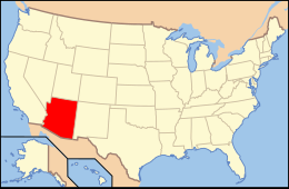
Arizona is a landlocked state situated in the southwestern region of the United States of America. It has a vast and diverse geography famous for its deep canyons, high- and low-elevation deserts, numerous natural rock formations, and volcanic mountain ranges. Arizona shares land borders with Utah to the north, the Mexican state of Sonora to the south, New Mexico to the east, and Nevada to the northwest, as well as water borders with California and the Mexican state of Baja California to the southwest along the Colorado River. Arizona is also one of the Four Corners states and is diagonally adjacent to Colorado.

<span class="mw-page-title-main">Geography of New Mexico</span>

With a total area of 121,590 square miles (314,900 km2), New Mexico is the fifth-largest state, after Alaska, Texas, California, and Montana. Its eastern border lies along 103°W longitude with the state of Oklahoma, and 2.2 miles west of 103°W longitude with Texas. On the southern border, Texas makes up the eastern two-thirds, while the Mexican states of Chihuahua and Sonora make up the western third, with Chihuahua making up about 90% of that. The western border with Arizona runs along the 109° 03'W longitude. The southwestern corner of the state is known as the Bootheel. The 37°N parallel forms the northern boundary with Colorado. The states of New Mexico, Colorado, Arizona, and Utah come together at the Four Corners in New Mexico's northwestern corner. Its surface water area is about 292 square miles (760 km2).

Lake Marcel is a private reservoir and community in unincorporated Carnation, Lake Marcel-Stillwater, King County, Washington, United States, in the foothills of the Cascades.

<span class="mw-page-title-main">Duxbury Reef State Marine Conservation Area</span> Protected area in California, US

Duxbury Reef State Marine Conservation Area (SMCA) is a marine protected area located about 1 mile (2 km) west of Bolinas in Marin County on California’s north central coast. This marine protected area covers 0.66 square miles (1.7 km2). Duxbury Reef SMCA prohibits the take of all living marine resources, except the recreational take of finfish from shore only and the recreational take of abalone.

References

  1. United States Census Bureau (Apr 2004). (Table 17) "United States Summary: 2000" . Retrieved August 29, 2011.{{cite web}}: Check |url= value (help)