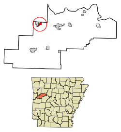
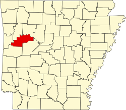
Caulksville, Arkansas | |
---|---|
Coordinates: 35°18′06″N93°52′05″W / 35.30167°N 93.86806°W | |
Country | United States |
State | Arkansas |
County | Logan |
Area | |
• Total | 1.36 sq mi (3.53 km2) |
• Land | 1.35 sq mi (3.49 km2) |
• Water | 0.01 sq mi (0.04 km2) |
Elevation | 394 ft (120 m) |
Population (2020) | |
• Total | 154 |
• Density | 114.24/sq mi (44.11/km2) |
Time zone | UTC-6 (Central (CST)) |
• Summer (DST) | UTC-5 (CDT) |
FIPS code | 05-12190 |
GNIS feature ID | 2406239 [2] |
Caulksville is a town [3] in Logan County, Arkansas, United States. The population was 213 at the 2010 census.
According to the United States Census Bureau, the town has a total area of 3.5 km2 (1.4 mi2), of which 3.5 km2 (1.4 mi2) is land and 0.74% is water.
Census | Pop. | Note | %± |
---|---|---|---|
1880 | 81 | — | |
1970 | 208 | — | |
1980 | 234 | 12.5% | |
1990 | 224 | −4.3% | |
2000 | 233 | 4.0% | |
2010 | 213 | −8.6% | |
2020 | 154 | −27.7% | |
U.S. Decennial Census [4] 2014 Estimate [5] |
As of the census [6] of 2000, there were 233 people, 97 households, and 67 families residing in the town. The population density was 66.6/km2 (172.1/mi2). There were 103 housing units at an average density of 29.5/km2 (76.1/mi2). The racial makeup of the town was 96.14% White, 1.72% Black or African American, 1.29% Native American, and 0.86% from two or more races. 0.86% of the population were Hispanic or Latino of any race.
There were 97 households, out of which 27.8% had children under the age of 18 living with them, 56.7% were married couples living together, 12.4% had a female householder with no husband present, and 29.9% were non-families. 26.8% of all households were made up of individuals, and 14.4% had someone living alone who was 65 years of age or older. The average household size was 2.40 and the average family size was 2.91.
In the town, the population was spread out, with 24.5% under the age of 18, 7.3% from 18 to 24, 23.2% from 25 to 44, 25.3% from 45 to 64, and 19.7% who were 65 years of age or older. The median age was 42 years. For every 100 females, there were 84.9 males. For every 100 females age 18 and over, there were 81.4 males.
The median income for a household in the town was $30,000, and the median income for a family was $33,250. Males had a median income of $30,729 versus $18,125 for females. The per capita income for the town was $21,428. About 13.9% of families and 13.7% of the population were below the poverty line, including 18.2% of those under the age of eighteen and 18.6% of those 65 or over.
Big Flat is a town in Baxter and Searcy counties in the U.S. state of Arkansas. The population was 88 at the 2020 census.
Everton is a town in Boone County, Arkansas, United States. The population was 133 at the 2010 census. It is part of the Harrison Micropolitan Statistical Area.
Valley Springs is a town in Boone County, Arkansas, United States. The population was 175 at the 2010 census. It is part of the Harrison Micropolitan Statistical Area.
Oak Grove is a town in Carroll County, Arkansas, United States. The population was 386 at the 2020 census.
Knobel (/ˈnoʊbəl/) is a city in Clay County, Arkansas, United States. The population was 147 at the 2020 census.
McDougal is a city in Clay County, Arkansas, United States. The population was 186 at the 2010 census.
Chester is a town in Crawford County, Arkansas, United States. It is part of the Fort Smith, Arkansas-Oklahoma Metropolitan Statistical Area. As of the 2020 Census the population was 144.
Winchester is a small town in northeast Drew County, Arkansas, United States. The population was 167 at the 2010 census, declining from its 20th-century high of 279 in 1980.
Moorefield is a town in Independence County, Arkansas, United States. It was named after Jesse A. Moore who owned most of the land in the area of the town at that time. The population was 137 at the 2010 census.
Amagon is a town in Jackson County, Arkansas, United States. The population was 98 at the 2010 census. It is the birthplace of former Governor of Arkansas Mike Beebe.
Campbell Station is a city in Jackson County, Arkansas, United States. The population was 255 at the 2010 census.
Moro is a town in Lee County, Arkansas, United States. The population was 216 at the 2010 census.
Birdsong is a town in Mississippi County, Arkansas, United States. The population was 32 at the 2020 census, down from 41 in 2010.
Rosston is a town in south-central Nevada County, Arkansas, United States. The population was 265 at the 2000 census. It is part of the Hope Micropolitan Statistical Area.
Western Grove is a town in northeastern Newton County, Arkansas, United States. The population was 384 at the 2010 census. It is part of the Harrison Micropolitan Statistical Area.
Ben Lomond is a town in Sevier County, Arkansas, United States. The population was 145 at the 2010 census.
Felsenthal is a town in Union County, Arkansas, United States. The population was 152 at the 2000 census and 150 at the 2010 census. It lays right on the Ouachita River in the southeastern corner of Union County. The small community attracts tourists from all over the state for the fishing and waterfowl hunting in the area.
Garner is a town in White County, Arkansas, United States. Brandy Goodwin is the current mayor. The population was 284 at the 2000 census.
Letona is a town in White County, Arkansas, United States. Sherrel Bennett is the current mayor. The population was 201 at the 2000 census.
Corinth is a town in Yell County, Arkansas, United States. The population was 65 at the 2000 census. It is part of the Russellville Micropolitan Statistical Area.